File:Malawi regions.svg
跳至導覽
跳至搜尋

此 SVG 檔案的 PNG 預覽的大小:424 × 600 像素。 其他解析度:170 × 240 像素 | 339 × 480 像素 | 543 × 768 像素 | 724 × 1,024 像素 | 1,448 × 2,048 像素 | 744 × 1,052 像素。
原始檔案 (SVG 檔案,表面大小:744 × 1,052 像素,檔案大小:1.08 MB)
說明
說明
添加單行說明來描述出檔案所代表的內容
摘要
[編輯]
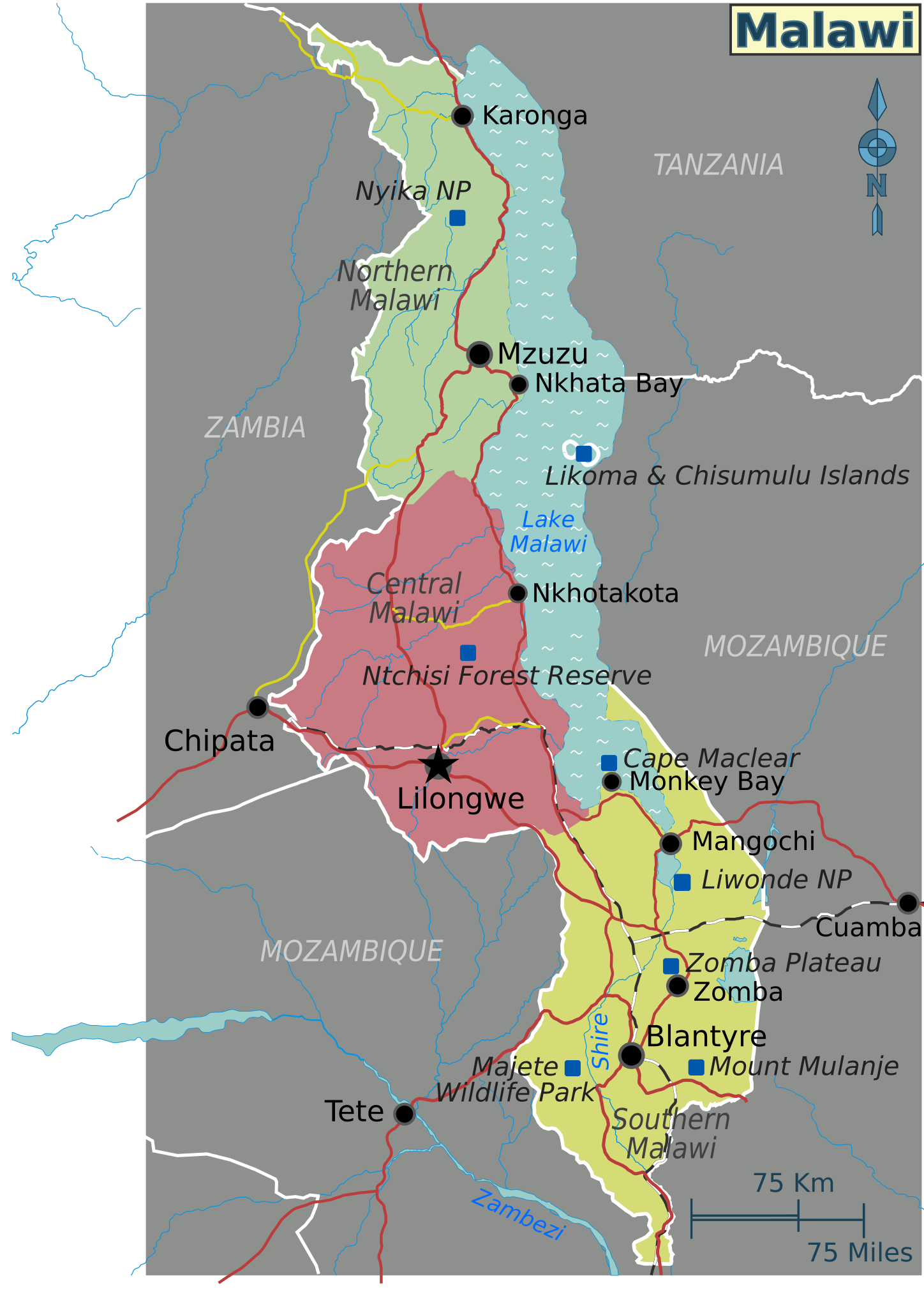
| 描述 | Map of Malawi with regions, major cities and other destinations noted (for use on Wikivoyage), multilingual SVG file | ||||
| 日期 | |||||
| 來源 |
自己的作品 based on the UN map of Malawi
|
||||
| 作者 | Shaund | ||||
| 其他版本 |
PNG files: |
授權條款
[編輯]
This file is licensed under the Creative Commons Attribution-Share Alike Attribution-Share Alike 4.0 International, 3.0 Unported, 2.5 Generic, 2.0 Generic and 1.0 Generic license.
- 您可以自由:
- 分享 – 複製、發佈和傳播本作品
- 重新修改 – 創作演繹作品
- 惟需遵照下列條件:
- 姓名標示 – 您必須指名出正確的製作者,和提供授權條款的連結,以及表示是否有對內容上做出變更。您可以用任何合理的方式來行動,但不得以任何方式表明授權條款是對您許可或是由您所使用。
- 相同方式分享 – 如果您利用本素材進行再混合、轉換或創作,您必須基於如同原先的相同或兼容的條款,來分布您的貢獻成品。
原始上傳日誌
[編輯]
| This file was imported from Wikivoyage WTS. |
The original description page was here. All following user names refer to wts.wikivoyage-old.
- 2010-02-01 05:41 (WT-shared) Shaund archive copy at the Wayback Machine 744×1052 (1133708 bytes) {{Imagecredit|credit=[[User:Shaund|Shaund]]|captureDate=31 Jan 2010|location=Malawi|source=Drawn by me based on map from [http://www.un.org/ (Import from wikitravel.org/shared)
檔案歷史
點選日期/時間以檢視該時間的檔案版本。
| 日期/時間 | 縮圖 | 尺寸 | 使用者 | 備註 | |
|---|---|---|---|---|---|
| 目前 | 2012年11月18日 (日) 00:45 | | 744 × 1,052(1.08 MB) | MGA73bot2(留言 | 貢獻) | {{BotMoveToCommons|wts.oldwikivoyage|year={{subst:CURRENTYEAR}}|month={{subst:CURRENTMONTHNAME}}|day={{subst:CURRENTDAY}}}} == {{int:filedesc}} == {{Information |description=Map of Malawi. SVG base map for Malawi regions, Malawi * Map of: Malawi¤ |dat... |
無法覆蓋此檔案。
檔案用途
沒有使用此檔案的頁面。
全域檔案使用狀況
以下其他 wiki 使用了這個檔案:
- ca.wikipedia.org 的使用狀況
- en.wikipedia.org 的使用狀況
- zh.wikipedia.org 的使用狀況