File:Malton signalbox geograph-3783003-by-Ben-Brooksbank.jpg
Jump to navigation
Jump to search
Size of this preview: 800 × 521 pixels. Other resolutions: 320 × 208 pixels | 640 × 417 pixels | 1,024 × 667 pixels | 1,280 × 834 pixels | 2,329 × 1,517 pixels.
Original file (2,329 × 1,517 pixels, file size: 4.93 MB, MIME type: image/jpeg)
Captions
Captions
Add a one-line explanation of what this file represents
Summary
[edit]
| Description |
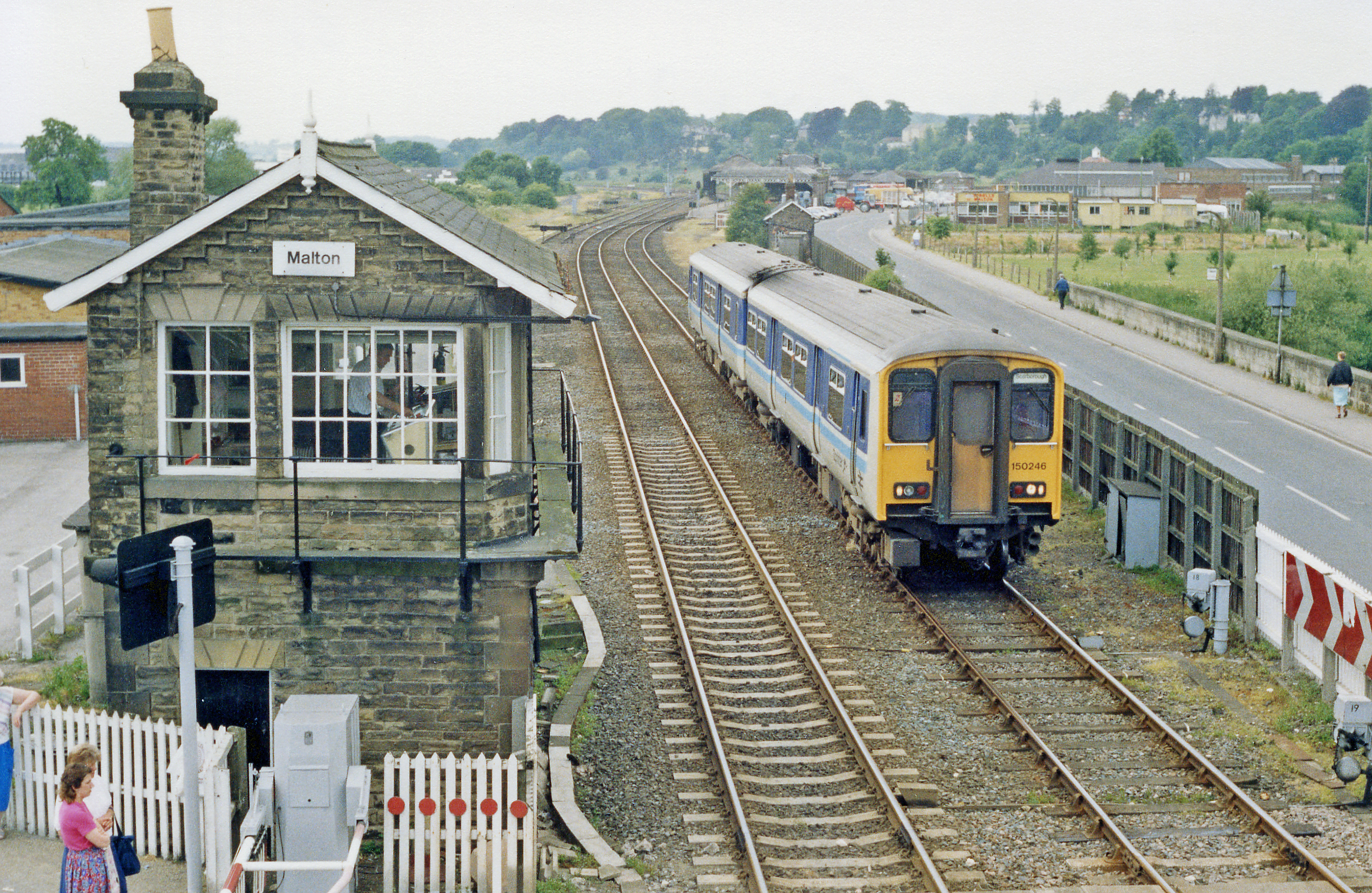
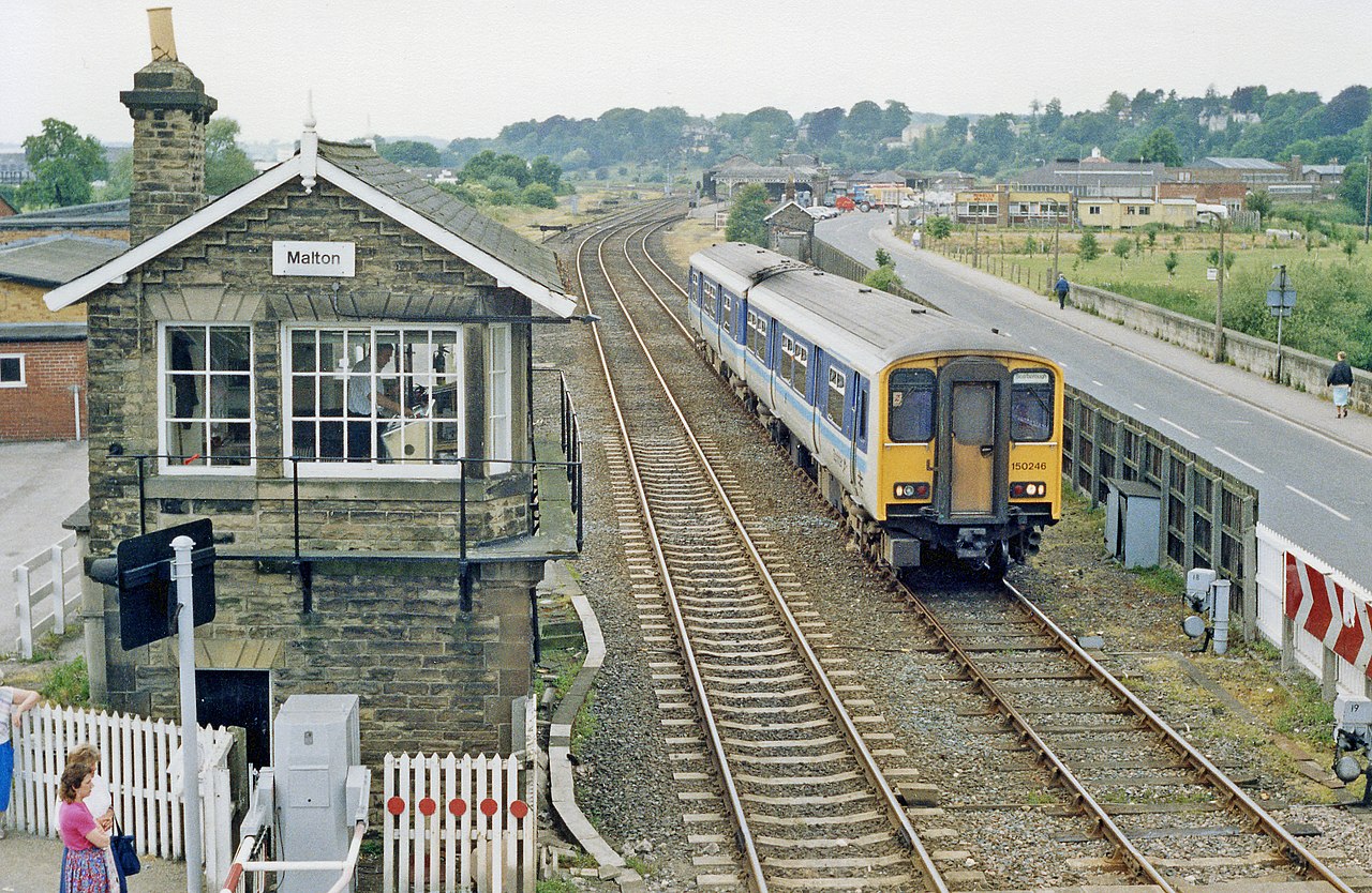
English: Malton: signalbox and train for Scarborough passing, 1988. View westward from a footbridge (later demolished) by the B1248 level-crossing, at Malton (former Malton East) Box, east of the station. This is main line of the ex-NER York - Scarborough (formerly also to Whitby via Rillington, closed 8/3/66 as far as Pickering, goods 4/7/66). Malton had been the junction of branches from Driffield (closed 5/6/50, goods 20/10/58), and Pilmoor via Gilling (local services ceased 31/12/30, but through holiday trains continued until 8/9/62, with goods ceasing west of Amortherby 2/2/53, the rest 19/10/64). The train comiing away from Malton station (just out sight) is the 09.42 express Liverpool Lime Street - Scarborough, consisting of a Class 150 DMU. |
| Date | |
| Source | From geograph.org.uk |
| Author | Ben Brooksbank |
| Permission (Reusing this file) |
Creative Commons Attribution Share-alike license 2.0 |
| Attribution (required by the license) | Ben Brooksbank / Malton: signalbox and train for Scarborough passing, 1988 / |
| Camera location | | View this and other nearby images on: OpenStreetMap |
|---|
Licensing
[edit]

|
This image was taken from the Geograph project collection. See this photograph's page on the Geograph website for the photographer's contact details. The copyright on this image is owned by Ben Brooksbank and is licensed for reuse under the Creative Commons Attribution-ShareAlike 2.0 license.
|
This file is licensed under the Creative Commons Attribution-Share Alike 2.0 Generic license.
Attribution: Ben Brooksbank
- You are free:
- to share – to copy, distribute and transmit the work
- to remix – to adapt the work
- Under the following conditions:
- attribution – You must give appropriate credit, provide a link to the license, and indicate if changes were made. You may do so in any reasonable manner, but not in any way that suggests the licensor endorses you or your use.
- share alike – If you remix, transform, or build upon the material, you must distribute your contributions under the same or compatible license as the original.
File history
Click on a date/time to view the file as it appeared at that time.
| Date/Time | Thumbnail | Dimensions | User | Comment | |
|---|---|---|---|---|---|
| current | 12:22, 29 December 2013 | | 2,329 × 1,517 (4.93 MB) | Chevin (talk | contribs) | == {{int:filedesc}} == {{Information |Description={{en|1='''Malton: signalbox and train for Scarborough passing, 1988.'''<br/> View westward from a footbridge (later demolished) by the B1248 level-crossing, at Malton (former Malton East) Box, east of t... |
You cannot overwrite this file.
File usage on Commons
The following page uses this file:
File usage on other wikis
The following other wikis use this file:
- Usage on en.wikipedia.org
Metadata
Categories:
- York to Scarborough Line at Norton-on-Derwent
- British Rail Class 150s of British Rail
- British Rail Class 150s in Regional Railways livery
- British Rail Class 150s on the York to Scarborough Line
- Trains of British Rail on the York to Scarborough Line
- Level crossings in North Yorkshire
- Signal boxes in North Yorkshire
- 1988 in rail transport in England
- June 1988 in North Yorkshire