File:Manhattan, V. 2, Plate No. 2 (Map bounded by 1st St., Allen St., Rivington St., Chrystie St.) NYPL1996102.tiff
Jump to navigation
Jump to search

Size of this JPG preview of this TIF file: 450 × 600 pixels. Other resolutions: 180 × 240 pixels | 360 × 480 pixels | 576 × 768 pixels | 768 × 1,024 pixels | 1,536 × 2,048 pixels | 5,399 × 7,198 pixels.

Original file (5,399 × 7,198 pixels, file size: 111.25 MB, MIME type: image/tiff, 2 pages)
Captions
Captions
Add a one-line explanation of what this file represents
Summary
[edit]| Description | Manhattan, V. 2, Plate No. 2 [Map bounded by 1st St., Allen St., Rivington St., Chrystie St.]; Atlases of New York city. / Insurance maps of New York. / Manhattan / Atlas 110. Vol. 2, 1903. | |||||||||||||||||||||||
| Catalogue call number | Map Div. (Sanborn Map Co. Insurance maps of N.Y.) | |||||||||||||||||||||||
| Item/Page/Plate | 2 | |||||||||||||||||||||||
| Date | ||||||||||||||||||||||||
| Source |
http://digitalgallery.nypl.org/nypldigital/dgkeysearchdetail.cfm?imageID=1996102
|
|||||||||||||||||||||||
| Author | Sanborn Map Company - Publisher | |||||||||||||||||||||||
| Permission (Reusing this file) |
From The Lionel Pincus and Princess Firyal Map Division. http://maps.nypl.org
|
|||||||||||||||||||||||
| Location | Stephen A. Schwarzman Building / The Lionel Pincus and Princess Firyal Map Division | |||||||||||||||||||||||
| Digital item published | 4-8-2011 | |||||||||||||||||||||||
| Digital ID | 1996102 | |||||||||||||||||||||||

The making of this file was supported by Wikimedia UK.
To see other files made with the support of Wikimedia UK, please see the category Supported by Wikimedia UK.
|
File history
Click on a date/time to view the file as it appeared at that time.
| Date/Time | Thumbnail | Dimensions | User | Comment | |
|---|---|---|---|---|---|
| current | 01:08, 11 May 2014 | 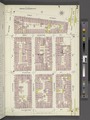 | 5,399 × 7,198, 2 pages (111.25 MB) | Fæ (talk | contribs) | GWToolset: Creating mediafile for Fæ. Tranche 4 -12906 reload @07:10 BST, 10 May 2014 |
You cannot overwrite this file.
File usage on Commons
There are no pages that use this file.