File:Manhattanhenge satellite view.svg
跳转到导航
跳转到搜索

此SVG文件的PNG预览的大小:400 × 600像素。 其他分辨率:160 × 240像素 | 320 × 480像素 | 512 × 768像素 | 682 × 1,024像素 | 1,365 × 2,048像素。
原始文件 (SVG文件,尺寸为512 × 768像素,文件大小:67 KB)
说明
说明
添加一行文字以描述该文件所表现的内容

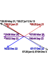
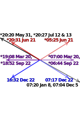
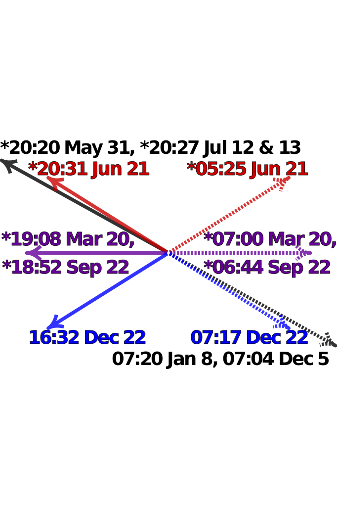
| 描述 | Satellite image of Manhattan, New York City centered on the intersection of Park Avenue and 34th Street, with directions and local times of sunrises (dotted lines) and sunsets (solid lines) on Manhattanhenge (black), summer solstice (red), equinoxes (purple) and winter solstice (blue) in 2011. Times marked with "*" have been adjusted for daylight saving. Data from http://www.esrl.noaa.gov/gmd/grad/solcalc/ and bitmap from http://earthobservatory.nasa.gov/IOTD/view.php?id=3678 and created by NASA. | |
| 日期 | (UTC) | |
| 来源 |
|
|
| 作者 |
|

W3C-validity not checked.

|
This SVG file contains embedded text that can be translated into your language, using any capable SVG editor, text editor or the SVG Translate tool. For more information see: About translating SVG files. |
| 这是一张修改过的图片,这意味着它已在原版本的基础上通过软件进行了编辑,改动内容:Update to 2012 and reduce clutter。其原始版本为:Manhattanhenge map.svg。修改者:Cmglee。
|
我,本作品著作权人,特此采用以下许可协议发表本作品:
本文件采用知识共享署名-相同方式共享 3.0 未本地化版本许可协议授权。
- 您可以自由地:
- 共享 – 复制、发行并传播本作品
- 修改 – 改编作品
- 惟须遵守下列条件:
- 署名 – 您必须对作品进行署名,提供授权条款的链接,并说明是否对原始内容进行了更改。您可以用任何合理的方式来署名,但不得以任何方式表明许可人认可您或您的使用。
- 相同方式共享 – 如果您再混合、转换或者基于本作品进行创作,您必须以与原先许可协议相同或相兼容的许可协议分发您贡献的作品。
原始上传日志
[编辑]
This image is a derivative work of the following images:
- File:Manhattanhenge_map.svg licensed with Cc-by-sa-3.0
- 2011-07-18T23:55:44Z Cmglee 512x768 (71587 Bytes) Fix text.
- 2011-07-18T23:47:00Z Cmglee 512x768 (71599 Bytes) {{Information |Description=Map of Manhattan, New York City centered on the intersection of Park Avenue and 34th Street, with times and directions of sunrises (dotted line) and sunsets (solid line) in 2011. Times marked with "
Uploaded with derivativeFX
文件历史
点击某个日期/时间查看对应时刻的文件。
| 日期/时间 | 缩略图 | 大小 | 用户 | 备注 | |
|---|---|---|---|---|---|
| 当前 | 2011年7月30日 (六) 00:48 | | 512 × 768(67 KB) | Cmglee(留言 | 贡献) | Bold text and arrows. |
| 2011年7月30日 (六) 00:39 |  | 512 × 768(67 KB) | Cmglee(留言 | 贡献) | Shrink text. | |
| 2011年7月30日 (六) 00:38 |  | 512 × 768(67 KB) | Cmglee(留言 | 贡献) | Use 2011 dates, darken purple text and enlarge text. | |
| 2011年7月28日 (四) 04:38 |  | 512 × 768(67 KB) | Cmglee(留言 | 贡献) | {{Information |Description=Satellite image of Manhattan, New York City centered on the intersection of Park Avenue and 34th Street, with directions and local times of sunrises (dotted lines) and sunsets (solid lines) on Manhattanhenge (black), summer sols |
您不可以覆盖此文件。
文件用途
以下4个页面使用本文件:
全域文件用途
以下其他wiki使用此文件:
- en.wikipedia.org上的用途
- es.wikipedia.org上的用途
- fa.wikipedia.org上的用途
- id.wikipedia.org上的用途
- it.wikipedia.org上的用途
- ja.wikipedia.org上的用途
- ko.wikipedia.org上的用途
- ms.wikipedia.org上的用途
- pt.wikipedia.org上的用途
- ro.wikipedia.org上的用途
- www.wikidata.org上的用途
- zh.wikipedia.org上的用途