File:Map Byzantine Empire 1025-fr.svg
Zur Navigation springen
Zur Suche springen

Größe der PNG-Vorschau dieser SVG-Datei: 800 × 450 Pixel. Weitere Auflösungen: 320 × 180 Pixel | 640 × 360 Pixel | 1.024 × 576 Pixel | 1.280 × 720 Pixel | 2.560 × 1.440 Pixel | 1.963 × 1.104 Pixel.
Originaldatei (SVG-Datei, Basisgröße: 1.963 × 1.104 Pixel, Dateigröße: 75 KB)
Bildtexte
Kurzbeschreibungen
Ergänze eine einzeilige Erklärung, was diese Datei darstellt.
Diese W3C-unbestimmte Vektorgrafik wurde mit Inkscape erstellt .
Beschreibung
[Bearbeiten]| Beschreibung |
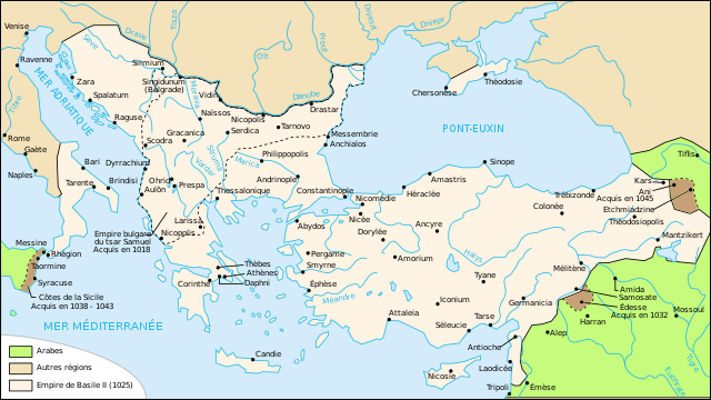
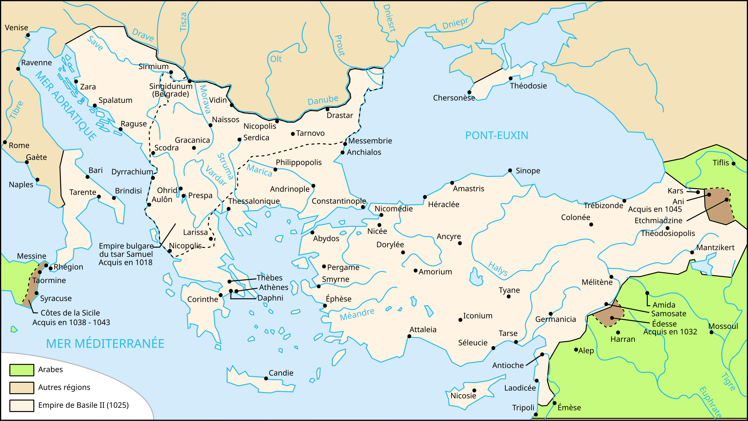
Français : L'empire byzantin à la mort de Basile II (1025). |
| Datum | |
| Quelle | Own work (data from Georges Duby, Atlas historique, page 38, map A). Image renamed from Image:Carte-Empire de Basile II.svg |
| Urheber | User:Nécropotame |
| Genehmigung (Weiternutzung dieser Datei) |
Diese Datei ist unter der Creative-Commons-Lizenz „Namensnennung – Weitergabe unter gleichen Bedingungen 2.5 generisch“ (US-amerikanisch) lizenziert.
|
| Andere Versionen |
[]
|


|
Diese SVG-Datei enthält eingebetteten Text, der mit jedem geeigneten SVG-Editor, Texteditor oder dem SVG-Übersetzungs-Werkzeug in deine Sprache übersetzt werden kann. Für mehr Informationen siehe Über das Übersetzen von SVG-Dateien. |
Dateiversionen
Klicke auf einen Zeitpunkt, um diese Version zu laden.
| Version vom | Vorschaubild | Maße | Benutzer | Kommentar | |
|---|---|---|---|---|---|
| aktuell | 21:43, 1. Nov. 2020 | | 1.963 × 1.104 (75 KB) | GrandEscogriffe (Diskussion | Beiträge) | corrections diverses |
| 10:40, 4. Dez. 2007 |  | 1.963 × 1.104 (71 KB) | Salli~commonswiki (Diskussion | Beiträge) | update | |
| 01:42, 27. Feb. 2007 |  | 1.963 × 1.104 (190 KB) | Bibi Saint-Pol (Diskussion | Beiträge) | {{Inkscape}} == Summary == {{Information |Description= {{fr|L'empire byzantin tel que l'a laissé Basile II à sa mort, en 1025.}} |Source=Own work (data from Georges Duby, ''Atlas historique'' (page 38, map A). |Date=2006-08-03 |Author=[[User:Necropotame |
Du kannst diese Datei nicht überschreiben.
Dateiverwendung
Die folgenden 43 Seiten verwenden diese Datei:
- Atlas of Albania
- Atlas of Bosnia and Herzegovina
- Atlas of Croatia
- Atlas of Cyprus
- Atlas of Italy
- Atlas of Kosovo
- Atlas of Montenegro
- Atlas of North Macedonia
- Atlas of Northern Cyprus
- Atlas of Serbia
- Atlas of Vojvodina
- User:Magog the Ogre/Multilingual legend/2020 November 1-10
- File:1025'te Doğu Roma İmparatorluğu.svg
- File:1025AD-ja.svg
- File:1025AD-ko.svg
- File:1025AD-pt.svg
- File:1025AD-zh.svg
- File:1025AD.svg
- File:1025AD GRC.svg
- File:1025AD LA.svg
- File:Byzantijnse Rijk 1025-hu.svg
- File:Byzantijnse Rijk 1025.svg
- File:Byzantine during the reign of Basil II hy.svg
- File:Byzantine during the reign of Basil II sr.svg
- File:Byzantium1025.jpg
- File:Bütsants 1025.png
- File:Map Byzantine Empire 1025-ar.svg
- File:Map Byzantine Empire 1025-de.svg
- File:Map Byzantine Empire 1025-el.svg
- File:Map Byzantine Empire 1025-en.svg
- File:Map Byzantine Empire 1025-es.svg
- File:Map Byzantine Empire 1025-fr.jpg
- File:Map Byzantine Empire 1025-fr.svg
- File:Map Byzantine Empire 1025-hu.svg
- File:Map Byzantine Empire 1025-it.svg
- File:Map Byzantine Empire 1025-mk.svg
- File:Map Byzantine Empire 1025-pl.svg
- File:Map Byzantine Empire 1025-pt.svg
- File:Map Byzantine Empire 1025-zh.svg
- File:Map of the Byzantine Empire, 1025 AD.PNG
- File:Map of the Byzantine Empire, 1025 AD.svg
- File:Map of the Byzantine Empire, 1025 AD ru.svg
- Template:Other versions/Map Byzantine Empire 1025
Globale Dateiverwendung
Die nachfolgenden anderen Wikis verwenden diese Datei:
- Verwendung auf an.wikipedia.org
- Verwendung auf cs.wikipedia.org
- Verwendung auf en.wikipedia.org
- Verwendung auf fr.wikipedia.org
- Années 1020
- Michel VI Bringas
- Histoire de l'Empire byzantin
- Michel Ier Cérulaire
- Bataille de Manzikert
- Romain IV Diogène
- Isaac Ier Comnène
- Jean Ier Tzimiskès
- Basile II
- Romain III Argyre
- Michel IV le Paphlagonien
- Michel V
- Nicéphore III Botaniatès
- Dynastie macédonienne
- Utilisateur:Nécropotame
- Christianisme en Turquie
- Asie (province romaine)
- Utilisateur:Nécropotame/Galerie
- Histoire de la Bosnie-Herzégovine
- Wikipédia:Atelier graphique/Cartes/Archives/mars 2008
- Histoire des Pouilles
- Guerres turco-byzantines
- Histoire de l'Anatolie
- Crimée byzantine
- Empire byzantin
- Empire byzantin sous les Doukas
- Verwendung auf gl.wikipedia.org
- Verwendung auf he.wikipedia.org
- Verwendung auf it.wikipedia.org
- Verwendung auf oc.wikipedia.org
- Verwendung auf sk.wikipedia.org
- Verwendung auf tr.wikipedia.org