File:Map Crusader states 1165-it.svg
Jump to navigation
Jump to search

Size of this PNG preview of this SVG file: 435 × 599 pixels. Other resolutions: 174 × 240 pixels | 348 × 480 pixels | 558 × 768 pixels | 744 × 1,024 pixels | 1,487 × 2,048 pixels | 955 × 1,315 pixels.
Original file (SVG file, nominally 955 × 1,315 pixels, file size: 129 KB)
Captions
Captions
Add a one-line explanation of what this file represents
Summary[edit]
| Description |
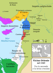
Italiano: Mappa del Vicino Oriente nel 1165 |
||
| Date | (UTC) | ||
| Source |
This file was derived from: |
||
| Author | |||
| Permission (Reusing this file) |
This file is licensed under the Creative Commons Attribution-Share Alike 3.0 Unported license. Attribution: MapMaster
|
||
| Other versions |
[]
See also[edit]
|


Original upload log[edit]
This image is a derivative work of the following images:
- File:Map Crusader states 1165-pt.svg licensed with Cc-by-3.0
- 2013-05-04T00:16:27Z Renato de Carvalho Ferreira 955x1315 (120116 Bytes) Correções gerais!
- 2013-03-26T02:33:12Z Renato de Carvalho Ferreira 955x1315 (120038 Bytes) Tradução do nome "Ascalon"
- 2013-03-09T21:55:42Z Renato de Carvalho Ferreira 955x1315 (121620 Bytes) User created page with UploadWizard
- File:Map Crusader states 1165-en.svg licensed with Cc-by-sa-3.0, GFDL
- 2010-07-12T21:21:34Z Malus Catulus 955x1315 (370421 Bytes) Removed the description box
- 2010-07-12T11:47:38Z Malus Catulus 955x1315 (421347 Bytes) Cilicia wasn't a kingdom yet
- 2010-07-12T11:29:04Z Malus Catulus 955x1315 (420526 Bytes) Added Zengid Dynasty
- 2010-07-12T11:25:39Z Malus Catulus 955x1315 (408043 Bytes) Updated it with Near East 1135.svg, changed emirate of Damascus to Zengid Dynasty
- 2009-11-07T23:22:24Z MapMaster 782x1226 (386491 Bytes) Changed date of Hattin to 1187
- 2009-11-06T03:34:37Z MapMaster 782x1226 (384671 Bytes) Changed text objects to paths.
- 2009-11-06T03:30:13Z MapMaster 782x1226 (236229 Bytes) {{Information |Description=A map of the Near East in the year 1165. |Source={{own}} |Author=[[User:MapMaster|MapMaster]] |Date=5 November 2009 |Permission= |other_versions= }} [[Category:Maps of the Kingdom of Jerusalem]]
Uploaded with derivativeFX
File history
Click on a date/time to view the file as it appeared at that time.
| Date/Time | Thumbnail | Dimensions | User | Comment | |
|---|---|---|---|---|---|
| current | 21:45, 24 March 2024 | | 955 × 1,315 (129 KB) | Arrow303 (talk | contribs) | typo |
| 21:32, 24 March 2024 |  | 955 × 1,315 (129 KB) | Arrow303 (talk | contribs) | == {{int:filedesc}} == {{Information |Description={{it|Mappa del Vicino Oriente nel 1165}} |Source={{Derived from|Map Crusader states 1165-pt.svg|Map Crusader states 1165-en.svg|display=50}} |Date=2024-03-24 21:28 (UTC) |Author= * File:Map Crusader states 1165-pt.svg: {{u|MapMaster}} * File:Map Crusader states 1165-en.svg: {{ul|MapMaster|Renato de Carvalho Ferreira}} * {{author|derivative|{{u|Arrow303}}}} |Per... |
You cannot overwrite this file.
File usage on Commons
The following 7 pages use this file:
File usage on other wikis
The following other wikis use this file:
Metadata
Categories:
- Maps of Cilicia
- Maps of the County of Tripoli
- Maps of the Kingdom of Jerusalem
- Maps of the Principality of Antioch
- Maps of the crusades
- Maps of the history of Cyprus
- Maps of the history of the Levant
- Maps of the history of the Middle East
- Maps showing 12th-century history
- Crusader states
- Italian-language SVG maps showing history
- Greater Israel