File:Map France 1030-br.svg
Jump to navigation
Jump to search

Size of this PNG preview of this SVG file: 526 × 599 pixels. Other resolutions: 211 × 240 pixels | 422 × 480 pixels | 674 × 768 pixels | 899 × 1,024 pixels | 1,799 × 2,048 pixels | 989 × 1,126 pixels.
Original file (SVG file, nominally 989 × 1,126 pixels, file size: 741 KB)
Captions
Captions
Add a one-line explanation of what this file represents
Summary[edit]
| Description |
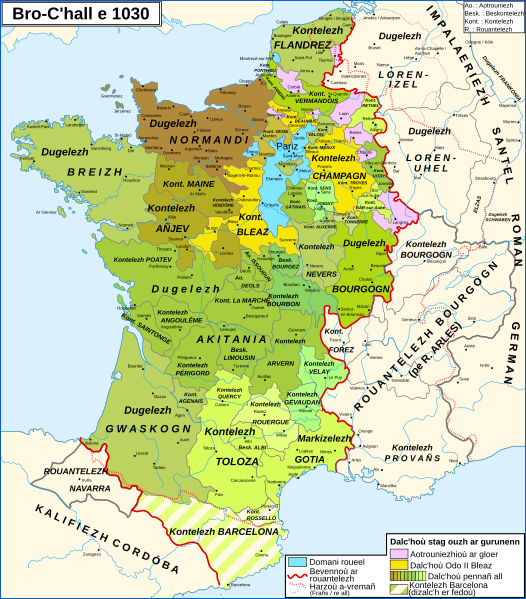
Brezhoneg: Kartenn Rouantelezh Bro-C'hall e 1030
English: Map of the France in 1030
Français : Carte de la France en 1030 |
| Date | |
| Source |
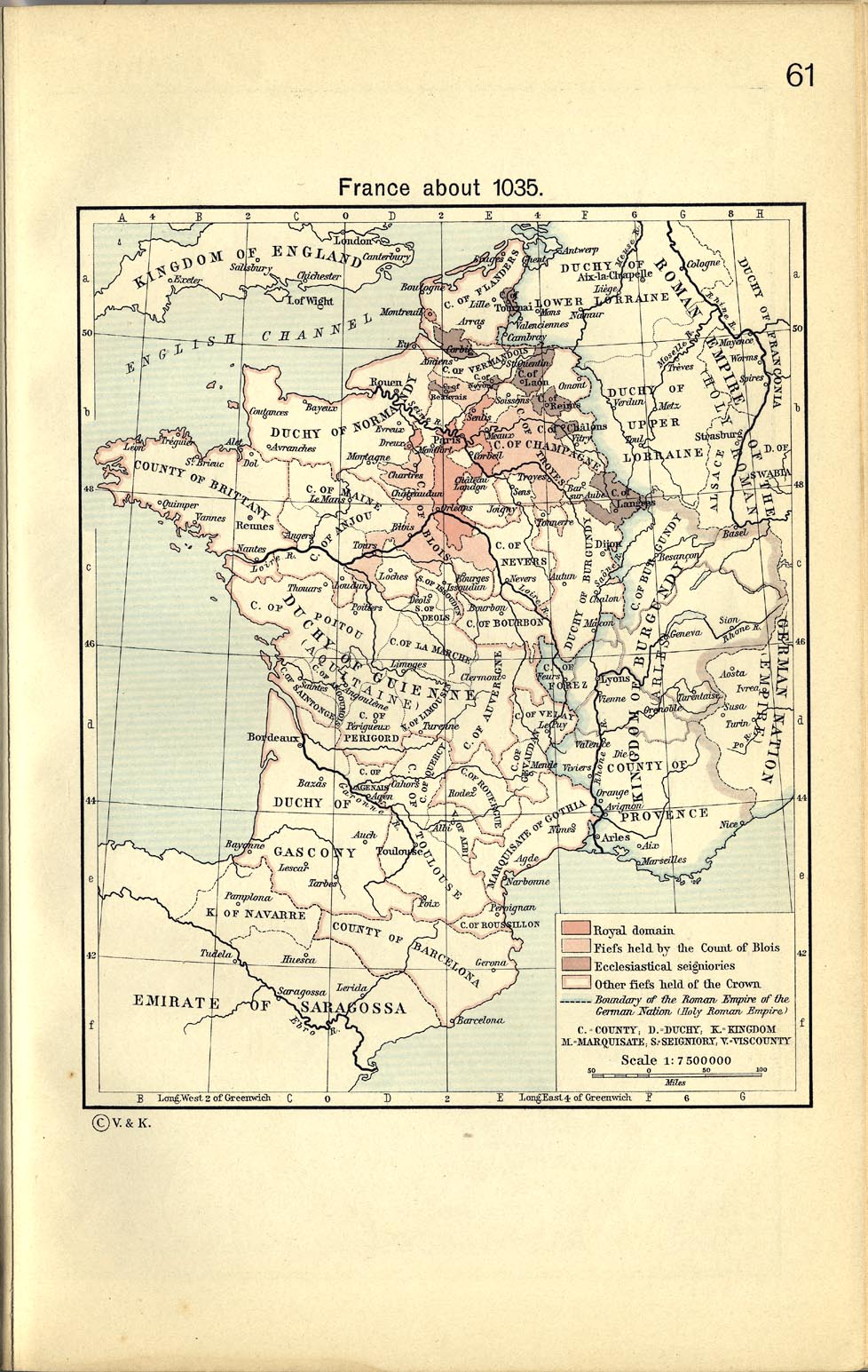
English: From France about 1035, in William R. Shepherd, The Historical Atlas, 1911
Data from the same and:
Français : D'après France about 1035, in William R. Shepherd, The Historical Atlas, 1911
Données d'après cette source et :
|
| Author |
|
| Other versions |
[]
|


Licensing[edit]
This file is licensed under the Creative Commons Attribution-Share Alike 3.0 Unported license.
- You are free:
- to share – to copy, distribute and transmit the work
- to remix – to adapt the work
- Under the following conditions:
- attribution – You must give appropriate credit, provide a link to the license, and indicate if changes were made. You may do so in any reasonable manner, but not in any way that suggests the licensor endorses you or your use.
- share alike – If you remix, transform, or build upon the material, you must distribute your contributions under the same or compatible license as the original.
File history
Click on a date/time to view the file as it appeared at that time.
| Date/Time | Thumbnail | Dimensions | User | Comment | |
|---|---|---|---|---|---|
| current | 17:18, 24 February 2024 | | 989 × 1,126 (741 KB) | Adriendelucca (talk | contribs) | testenn adaozet / ajustement de texte |
| 15:52, 4 October 2023 |  | 989 × 1,126 (712 KB) | Adriendelucca (talk | contribs) | Uploaded a work by *File:Map_France_1030-fr.svg: Zigeuner *troet e brezhoneg gant Adriendelucca from {{en|Own work, from [http://www.lib.utexas.edu/maps/historical/shepherd_1911/shepherd-c-061.jpg France about 1035], in William R. Shepherd, ''The Historical Atlas'', 1911 Data from the same and: *Olivier Guyotjeannin, ''Atlas de l'histoire de France IXe-XVe siècle'', Paris, 2005 *François Menant, H. Martin, B. Merdignac & M. Chauvin, ''Les Capétien... |
You cannot overwrite this file.
File usage on Commons
The following 11 pages use this file:
- User:Adriendelucca
- User:Chumwa/OgreBot/Travel and communication maps/2023 October 1-10
- User:Chumwa/OgreBot/Travel and communication maps/2024 February 20-29
- User:Magog the Ogre/Multilingual legend/2023 October 1-4
- User:Magog the Ogre/Multilingual legend/2024 February 20-24
- File:Map France 1030-br.svg
- File:Map France 1030-de.svg
- File:Map France 1030-es.svg
- File:Map France 1030-fr.svg
- File:Map France 1030-ru.svg
- Template:Other versions/France 1030
File usage on other wikis
The following other wikis use this file:
- Usage on br.wikipedia.org
Metadata
Categories:
- Breton-language maps
- Breton-language SVG maps
- SVG maps of the history of France
- Maps showing 11th-century history
- Maps of 11th-century France
- Maps showing 1030
- County of Champagne
- Kingdom of Burgundy
- County of Burgundy
- Duchy of Burgundy
- Maps of the county of Flanders
- Duchy of Brittany
- Duchy of Normandy
- Maps of the history of Lorraine
- Maine (province)
- Maps of Poitou
- Bourbonnais
- Nivernais
- Marche (province)
- County of Anjou
- Angoumois
- Saintonge
- County of Auvergne
- Forez
- Maps of Limousin
- Maps of the history of Provence
- Kingdom of Navarre
- Maps of the County of Barcelona
- County of Toulouse
- Roussillon
- Maps of Gascogne