File:Map France 1030-es.svg
ナビゲーションに移動
検索に移動

この SVG ファイルのこの PNG プレビューのサイズ: 526 × 599 ピクセル. その他の解像度: 211 × 240 ピクセル | 421 × 480 ピクセル | 674 × 768 ピクセル | 899 × 1,024 ピクセル | 1,799 × 2,048 ピクセル | 1,053 × 1,199 ピクセル。
元のファイル (SVG ファイル、1,053 × 1,199 ピクセル、ファイルサイズ: 4.12メガバイト)
キャプション
キャプション
このファイルの内容を1行で記述してください
概要
[編集]| 解説 |
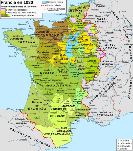
English: Map of the France in 1030 Español: Mapa de Francia en 1030 Français : Carte de la France en 1030 |
| 日付 | (UTC) |
| 原典 | |
| 作者 |
|
| その他のバージョン |
[]
|


この画像には画像編集が施されています。原本に対してデジタル的な変更が行われました。
|
この作品の著作権者である私は、この作品を以下のライセンスで提供します。
- あなたは以下の条件に従う場合に限り、自由に
- 共有 – 本作品を複製、頒布、展示、実演できます。
- 再構成 – 二次的著作物を作成できます。
- あなたの従うべき条件は以下の通りです。
- 表示 – あなたは適切なクレジットを表示し、ライセンスへのリンクを提供し、変更があったらその旨を示さなければなりません。これらは合理的であればどのような方法で行っても構いませんが、許諾者があなたやあなたの利用行為を支持していると示唆するような方法は除きます。
- 継承 – もしあなたがこの作品をリミックスしたり、改変したり、加工した場合には、あなたはあなたの貢献部分を元の作品とこれと同一または互換性があるライセンスの下に頒布しなければなりません。
あなたは上記のライセンスから、どれか一つ以上を選択できます。
元のアップロードログ
[編集]
This image is a derivative work of the following images:
- File:Map_France_1030-fr.svg licensed with Cc-by-sa-3.0,2.5,2.0,1.0, Cc-by-sa-3.0,2.5,2.0,1.0
- 2008-06-18T20:16:34Z Zigeuner 988x1124 (810778 Bytes) {{Information |Description={{en|1=Map of the France in 1030}} {{fr|1=Carte de la France en 1030}} |Source=travail personnel (own work) [http://www.lib.utexas.edu/maps/historical/shepherd_1911/shepherd-c-061.jpg] |Author=[[Use
Uploaded with derivativeFX
ファイルの履歴
過去の版のファイルを表示するには、その版の日時をクリックしてください。
| 日付と時刻 | サムネイル | 寸法 | 利用者 | コメント | |
|---|---|---|---|---|---|
| 現在の版 | 2017年4月29日 (土) 22:14 | | 1,053 × 1,199 (4.12メガバイト) | Rowanwindwhistler (トーク | 投稿記録) | https://en.wikipedia.org/wiki/Wikipedia:WikiProject_Maps/Conventions Fake text added. Islands added back from the French map. Minor corrections in names (Aquisgrán, Carcasona...). |
| 2009年1月20日 (火) 17:54 |  | 988 × 1,124 (792キロバイト) | Phirosiberia (トーク | 投稿記録) | {{Information |Description= |Source= |Date= |Author= |Permission= |other_versions= }} | |
| 2009年1月20日 (火) 17:43 |  | 988 × 1,124 (792キロバイト) | Phirosiberia (トーク | 投稿記録) | {{Information |Description={{en|1=Map of the France in 1030}} {{es|1=Mapa de Francia en 1030}} {{fr|1=Carte de la France en 1030}} |Source=*File:Map_France_1030-fr.svg |Date=2009-01-20 17:42 (UTC) |Author=*derivative work: ~~~ *[[:File:Map_France_10 |
このファイルは上書きできません。
ファイルの使用状況
以下の 10 ページがこのファイルを使用しています:
- User:Chumwa/OgreBot/Charente-Maritime/2017 April 21-30
- File:Map France 1030-br.svg
- File:Map France 1030-ca.svg
- File:Map France 1030-de.svg
- File:Map France 1030-es.svg
- File:Map France 1030-fr.svg
- File:Map France 1030-ru.svg
- File:Map France 1180-ru.svg
- File:Mapa Itinerario Sigerico año 990.svg
- Template:Other versions/France 1030
グローバルなファイル使用状況
以下に挙げる他のウィキがこの画像を使っています:
- el.wikipedia.org での使用状況
- en.wikipedia.org での使用状況
- es.wikipedia.org での使用状況
- gl.wikipedia.org での使用状況
- hu.wikipedia.org での使用状況
- ja.wikipedia.org での使用状況
メタデータ
カテゴリ:
- Maps showing 1030
- Maps showing 11th-century history
- Maps of 11th-century France
- SVG maps of the history of France
- Spanish-language SVG maps
- County of Champagne
- Maps of the county of Flanders
- Duchy of Burgundy
- County of Burgundy
- Kingdom of Burgundy
- Duchy of Brittany
- Duchy of Normandy
- Maps of the history of Lorraine
- Maine (province)
- County of Anjou
- Marche (province)
- Nivernais
- Bourbonnais
- Maps of Poitou
- Angoumois
- Saintonge
- County of Auvergne
- Forez
- Maps of Limousin
- Maps of the history of Provence
- Kingdom of Navarre
- Maps of the County of Barcelona
- County of Toulouse
- Maps of Gascogne
- Maps of the Kingdom of France
- Roussillon