File:Map France 1180-fr.svg
跳至導覽
跳至搜尋

此 SVG 檔案的 PNG 預覽的大小:527 × 600 像素。 其他解析度:211 × 240 像素 | 422 × 480 像素 | 675 × 768 像素 | 900 × 1,024 像素 | 1,800 × 2,048 像素 | 988 × 1,124 像素。
原始檔案 (SVG 檔案,表面大小:988 × 1,124 像素,檔案大小:1.88 MB)
說明
說明
添加單行說明來描述出檔案所代表的內容
Légende
[編輯]摘要
[編輯]| 描述 |
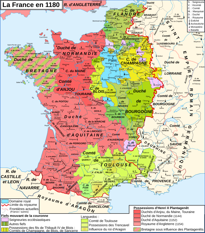
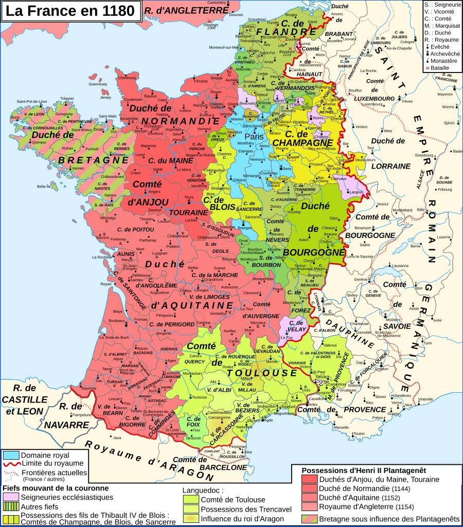
English: Map of France in 1180
Français : Carte de la France en 1180 |
| 日期 | |
| 來源 |
English: Own work, from Image:France 12thC.jpg, in William R. Shepherd, The Historical Atlas, 1911
Data from the same and:
Français : Création personnelle, d'après Image:France 12thC.jpg, in William R. Shepherd, The Historical Atlas, 1911
Données d'après cette source et :
|
| 作者 | Zigeuner |
| 其他版本 |
[]
Derivative works of this file:
|


.png)

|
This SVG file contains embedded text that can be translated into your language, using any capable SVG editor, text editor or the SVG Translate tool. For more information see: About translating SVG files. |
授權條款
[編輯]
我,本作品的著作權持有者,決定用以下授權條款發佈本作品:

|
已授權您依據自由軟體基金會發行的無固定段落、封面文字和封底文字GNU自由文件授權條款1.2版或任意後續版本,對本檔進行複製、傳播和/或修改。該協議的副本列在GNU自由文件授權條款中。 |
您可以選擇您需要的授權條款。
檔案歷史
點選日期/時間以檢視該時間的檔案版本。
| 日期/時間 | 縮圖 | 尺寸 | 使用者 | 備註 | |
|---|---|---|---|---|---|
| 目前 | 2009年1月9日 (五) 11:35 | | 988 × 1,124(1.88 MB) | ZigeunerAlt(留言 | 貢獻) | + seigneurie de Montpensier, couleur du Velay, vicomté de Marsan |
| 2008年12月12日 (五) 15:51 |  | 988 × 1,124(1.88 MB) | ZigeunerAlt(留言 | 貢獻) | Retour des limites d'arrière-fiefs dans le duché d'Aquitaine | |
| 2008年12月12日 (五) 14:07 |  | 988 × 1,124(1.88 MB) | ZigeunerAlt(留言 | 貢獻) | + comté d'Alençon, seigneurie d'Harcourt (Normandie) | |
| 2008年12月6日 (六) 15:42 |  | 988 × 1,124(1.88 MB) | ZigeunerAlt(留言 | 貢獻) | Tonnerre de la même couleur que Nevers et Auxerre | |
| 2008年12月5日 (五) 22:43 |  | 988 × 1,124(1.88 MB) | ZigeunerAlt(留言 | 貢獻) | Couleurs identiques pour Flandres/Vermandois/Valois | |
| 2008年12月3日 (三) 15:02 |  | 988 × 1,124(1.88 MB) | ZigeunerAlt(留言 | 貢獻) | {{Information |Description={{en|1=Map of the France in 1180}} {{fr|1=Carte de la France en 1180}} |Source=travail personnel (own work) |Author=Zigeuner |Date=3 XII 2008 |Permission= |other_versions=Image:Map France 1030-fr.svg }} <!--{{ |
無法覆蓋此檔案。
檔案用途
下列15個頁面有用到此檔案:
- Sancerre
- File:County of Soissons (1180).png
- File:France 12thC.jpg
- File:Frankreich 12. Jh (ohne Süd).png
- File:Frankreich 12. Jh 2021-08-03.png
- File:Map France 1030-fr.svg
- File:Map France 1180-br.svg
- File:Map France 1180-de.svg
- File:Map France 1180-es.svg
- File:Map France 1180-fr.svg
- File:Map France 1180-ru.svg
- File:Map France 1180-uk.svg
- File:Map of Poitou in 1180.png
- File:Pontigny1180.png
- Template:Other versions/Map France 1180
.png)
全域檔案使用狀況
以下其他 wiki 使用了這個檔案:
- avk.wikipedia.org 的使用狀況
- bg.wikipedia.org 的使用狀況
- bn.wikibooks.org 的使用狀況
- cs.wikipedia.org 的使用狀況
- da.wikipedia.org 的使用狀況
- de.wikipedia.org 的使用狀況
- el.wikipedia.org 的使用狀況
- en.wikipedia.org 的使用狀況
- en.wikibooks.org 的使用狀況
- eo.wikipedia.org 的使用狀況
- es.wikipedia.org 的使用狀況
- et.wikipedia.org 的使用狀況
- eu.wikipedia.org 的使用狀況
- fr.wikipedia.org 的使用狀況
檢視此檔案的更多全域使用狀況。
詮釋資料
分類:
- SVG maps of the history of France
- French-language SVG maps showing history
- Maps of 12th-century France
- Angevin Empire
- County of Champagne
- Maps of the county of Flanders
- Duchy of Burgundy
- County of Burgundy
- Duchy of Brittany
- Maps of the history of Hainaut
- Maps of the history of Brabant
- Maps of the Duchy of Lorraine
- Duchy of Normandy
- Maine (province)
- County of Anjou
- Touraine
- Duchy of Aquitaine
- Nivernais
- Bourbonnais
- Maps of Poitou
- Angoumois
- County of Auvergne
- Maps of Dauphiné
- Maps of the Duchy of Savoy
- Maps of the history of Provence
- County of Toulouse
- County of Foix
- Roussillon
- Kingdom of Navarre
- Duchy of Luxembourg
- Astarac
- Geography of Béarn
- Bigorre
- Maps of Comminges
- Maps of Aunis
- Perche