File:Map Kingdom Arelat EN.png
Aller à la navigation
Aller à la recherche
Taille de cet aperçu : 587 × 600 pixels. Autres résolutions : 235 × 240 pixels | 470 × 480 pixels | 752 × 768 pixels | 1 003 × 1 024 pixels | 1 310 × 1 338 pixels.
Fichier d’origine (1 310 × 1 338 pixels, taille du fichier : 209 kio, type MIME : image/png)
Légendes
Légendes
Ajoutez en une ligne la description de ce que représente ce fichier
Description[modifier]
| Description |
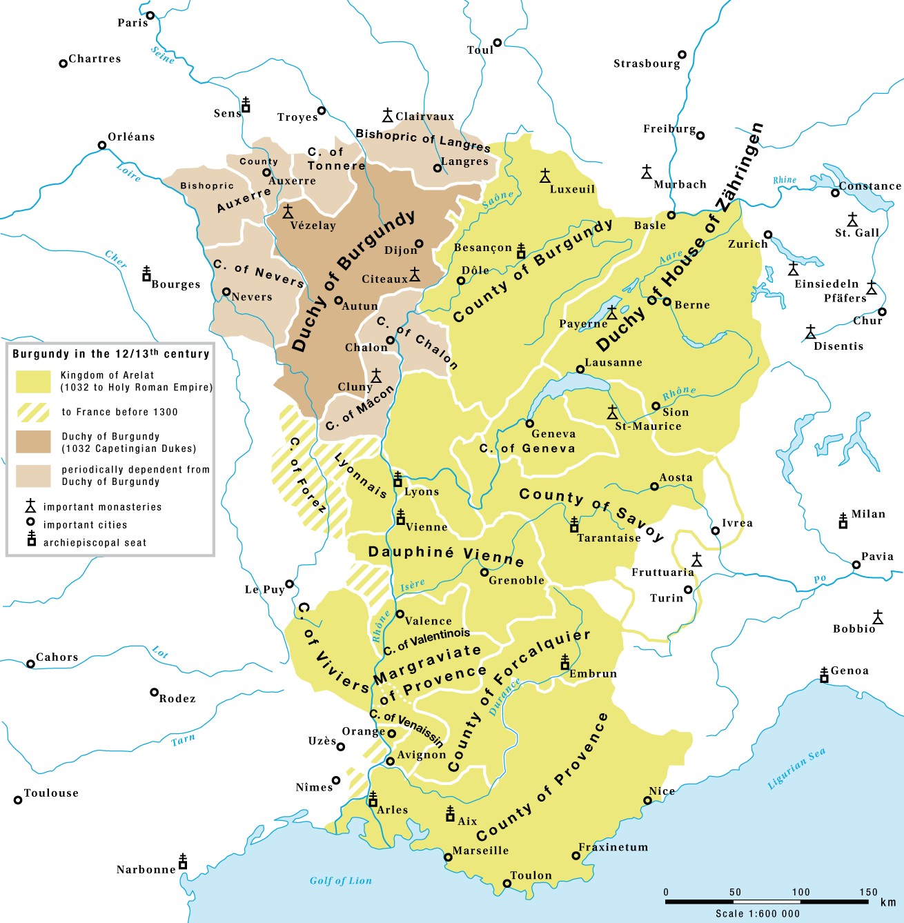
English: The Kingdom of Arelat and the Capetian Duchy of Burgundy in the 12/13th century |
| Date | |
| Source | Travail personnel |
| Auteur | Marco Zanoli (Sidonius) |
| Autres versions |
|


Conditions d’utilisation[modifier]
You may use my work outside wikipedia for free as long as you name me as the author. If you would like to use my work in a print medium, please send me a specimen copy.
Contact me if you have questions regarding the license or if you want individual changes to the map (marco.zanoli at hotmail.ch). Ce fichier est sous la licence Creative Commons Attribution – Partage dans les Mêmes Conditions 4.0 International. Attribution: Marco Zanoli
|
Historique du fichier
Cliquer sur une date et heure pour voir le fichier tel qu'il était à ce moment-là.
| Date et heure | Vignette | Dimensions | Utilisateur | Commentaire | |
|---|---|---|---|---|---|
| actuel | 4 juillet 2010 à 04:58 | | 1 310 × 1 338 (209 kio) | DcoetzeeBot (d | contributions) | Remove watermark, add author and license data to image metadata, decrease filesize with pngcrush |
| 15 février 2009 à 17:30 |  | 1 310 × 1 338 (379 kio) | Sidonius (d | contributions) | territories to france before 1300, margraviate provence | |
| 15 février 2009 à 14:51 |  | 1 310 × 1 338 (378 kio) | Sidonius (d | contributions) | small corrections, Duchy of House of Zähringen | |
| 13 février 2009 à 16:34 |  | 1 310 × 1 338 (351 kio) | Sidonius (d | contributions) | == Beschreibung == {{Information |Description={{en|The Kingdom of Arelat and the Capetingian Duchy of Burgundy in the 12/13th century}} |Source=Eigenes Werk (own work) |Author=Marco Zanoli (Sidonius) |Date=12.2.2009 |Permission= |other_v |
Vous ne pouvez pas remplacer ce fichier.
Utilisations locales du fichier
Les 9 pages suivantes utilisent ce fichier :
Utilisations du fichier sur d’autres wikis
Les autres wikis suivants utilisent ce fichier :
- Utilisation sur ar.wikipedia.org
- Utilisation sur be.wikipedia.org
- Utilisation sur bg.wikipedia.org
- Utilisation sur cs.wikipedia.org
- Utilisation sur de.wikipedia.org
- Utilisation sur el.wikipedia.org
- Utilisation sur en.wikipedia.org
- Utilisation sur es.wikipedia.org
- Utilisation sur et.wikipedia.org
- Utilisation sur eu.wikipedia.org
- Utilisation sur fa.wikipedia.org
- Utilisation sur fr.wikipedia.org
- Utilisation sur he.wikipedia.org
- Utilisation sur id.wikipedia.org
- Utilisation sur it.wikipedia.org
- Utilisation sur ja.wikipedia.org
- Utilisation sur lt.wikipedia.org
- Utilisation sur mt.wikipedia.org
- Utilisation sur nl.wikipedia.org
- Utilisation sur pl.wikipedia.org
- Utilisation sur ro.wikipedia.org
Voir davantage sur l’utilisation globale de ce fichier.
Catégories :
- Maps of the history of Burgundy
- History of Bourgogne
- Maps of the kingdom of France
- Maps of the history of Switzerland
- Duchy of Burgundy
- County of Burgundy
- Nivernais
- Maps of Lyonnais
- Forez
- Maps of Dauphiné
- Maps of the Duchy of Savoy
- Maps of the history of Provence
- Maps of 11th-century Europe
- Maps of 12th-century Europe
- Kingdom of Arles
- Kingdom of Burgundy