File:Map Macedonia 336 BC-es.svg
跳转到导航
跳转到搜索

此SVG文件的PNG预览的大小:749 × 600像素。 其他分辨率:300 × 240像素 | 600 × 480像素 | 960 × 768像素 | 1,279 × 1,024像素 | 2,559 × 2,048像素 | 992 × 794像素。
原始文件 (SVG文件,尺寸为992 × 794像素,文件大小:3.41 MB)
说明
说明
添加一行文字以描述该文件所表现的内容
| 描述 |
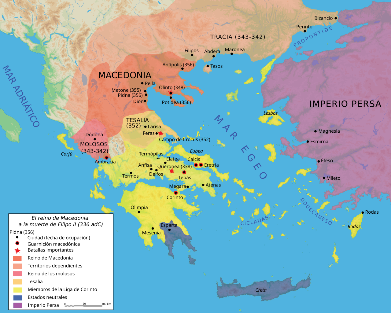
Español: Mapa del reino de Filipo II a su muerte, 336 adC |
||||||||
| 日期 | |||||||||
| 来源 |
Own work using Adobe Illustrator (data from R. Ginouvès and al., La Macédoine, Paris, 1992). Translated from Image:Map Macedonia 336 BC-fr.svg. |
||||||||
| 作者 | Marsyas; Kordas | ||||||||
| 授权 (二次使用本文件) |
我,本作品著作权人,特此采用以下许可协议发表本作品:
本文件采用知识共享署名-相同方式共享 2.5 通用许可协议授权。
您可以选择您需要的许可协议。 |
||||||||
| 其他版本 |
[]
|


|
This SVG file contains embedded text that can be translated into your language, using any capable SVG editor, text editor or the SVG Translate tool. For more information see: About translating SVG files. |
文件历史
点击某个日期/时间查看对应时刻的文件。
| 日期/时间 | 缩略图 | 大小 | 用户 | 备注 | |
|---|---|---|---|---|---|
| 当前 | 2007年6月27日 (三) 22:24 | | 992 × 794(3.41 MB) | Bibi Saint-Pol(留言 | 贡献) | fix several SVG problems; restore legend: this is part of the map |
| 2017年3月20日 (一) 08:11 |  | 1,058 × 847(4.07 MB) | Rowanwindwhistler(留言 | 贡献) | https://en.wikipedia.org/wiki/Wikipedia:WikiProject_Maps/Conventions Fake text added | |
| 2016年2月25日 (四) 07:36 |  | 992 × 794(3.59 MB) | Rowanwindwhistler(留言 | 贡献) | Cleaner version, height per layer for easier modification, duplication of islands removed. | |
| 2016年2月25日 (四) 06:56 |  | 992 × 794(3.06 MB) | Rowanwindwhistler(留言 | 贡献) | Battle symbols on top | |
| 2016年2月22日 (一) 09:28 |  | 992 × 794(3.06 MB) | Rowanwindwhistler(留言 | 贡献) | Eubea corrected | |
| 2015年12月29日 (二) 19:20 |  | 992 × 794(3.06 MB) | Rowanwindwhistler(留言 | 贡献) | No transparency for the sea | |
| 2015年12月29日 (二) 19:17 |  | 992 × 794(3.06 MB) | Rowanwindwhistler(留言 | 贡献) | Coast added, sea colour changed as per https://en.wikipedia.org/wiki/Wikipedia:WikiProject_Maps/Conventions | |
| 2007年6月27日 (三) 22:29 |  | 992 × 794(3.41 MB) | Bibi Saint-Pol(留言 | 贡献) | {{Information |Description= {{es|Mapa del reino de Filipo II a su muerte, 336 adC}} Source=Own work using Adobe Illustrator (data from R. Ginouvès and al., ''La Macédoine'', Paris, 1992). Translated from [[:Image:Map Macedonia 336 | |
| 2007年6月13日 (三) 23:54 |  | 993 × 794(3.43 MB) | Ignacio Icke(留言 | 贡献) | -legend off | |
| 2007年6月12日 (二) 23:29 |  | 993 × 794(3.43 MB) | Ignacio Icke(留言 | 贡献) | trying to solve the rectangles thing |
您不可以覆盖此文件。
文件用途
以下18个页面使用本文件:
- File:Karte Makedonien 336 vC-de.svg
- File:Macedonia y Grecia (336 adC).svg(文件重定向)
- File:Map Macedonia 336 BC-ar.svg
- File:Map Macedonia 336 BC-bg.svg
- File:Map Macedonia 336 BC-ce.svg
- File:Map Macedonia 336 BC-de.svg
- File:Map Macedonia 336 BC-en.svg
- File:Map Macedonia 336 BC-es.svg
- File:Map Macedonia 336 BC-fr.svg
- File:Map Macedonia 336 BC-he-2.svg
- File:Map Macedonia 336 BC-he.svg
- File:Map Macedonia 336 BC-it.svg
- File:Map Macedonia 336 BC-ka.svg
- File:Map Macedonia 336 BC-pt.svg
- File:Map Macedonia 336 BC-ru.svg
- File:Map Macedonia 336 BC-zh.svg
- File:மாசிடோனியா கி. மு. 336.svg
- Template:Other versions/Map Macedonia 336 BC
.svg&redirect=no)
全域文件用途
以下其他wiki使用此文件:
- ast.wikipedia.org上的用途
- es.wikipedia.org上的用途
- eu.wikipedia.org上的用途
- gl.wikipedia.org上的用途
- hu.wikipedia.org上的用途
- la.wikipedia.org上的用途
- pl.wikipedia.org上的用途
- sq.wikipedia.org上的用途