File:Map of eastern Virginia, 1862 LOC lva0000092.tif
Jump to navigation
Jump to search

Size of this JPG preview of this TIF file: 471 × 600 pixels. Other resolutions: 188 × 240 pixels | 377 × 480 pixels | 603 × 768 pixels | 804 × 1,024 pixels | 1,608 × 2,048 pixels | 6,352 × 8,089 pixels.
Original file (6,352 × 8,089 pixels, file size: 147 MB, MIME type: image/tiff)
Captions
Captions
Add a one-line explanation of what this file represents
Summary
[edit]| Description |
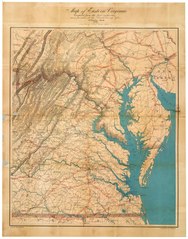
English: Accompanied by cover: Map of eastern Virginia / compiled in the office of the United States Coast Survey. Washington, D.C. : W.H. & O.H. Morrison. 15 x 10 cm. Also covers Maryland, Delaware, southeastern Pennsylvania and parts of New Jersey and North Carolina. Red concentric circles centered on Richmond. Relief shown by hachures. Shows roads, rivers, names of cities, and railroads converging in Richmond, Washington, D.C., Baltimore, and Philadelphia, and topography of eastern Virginia and southereastern Pennsylvania. This item is in the Map Collection of the Library of Virginia; please contact the Library's Archives Research Services department for more information. LC Civil War maps (2nd ed.), 465.35 Swem, E.G. Maps relating to Virginia, 929 Available also through the Library of Congress Web site as a raster image. April 1920, Jas. H. Hall, c; Feb. 2003, Map Cataloging Team. Civil War project no.: lva00092. Conservation: restored Nov. 1951, Etherington Conservation Center, Dec. 2002. Digital image available: 26 x 20 1/2 in. Map accession no. 1683. Previously filed as: 755 1862. |
||
| Title | Map of eastern Virginia, 1862 | ||
| Shelf ID | https://www.loc.gov/item/lva0000092/ | ||
| Date | |||
| Source | https://www.loc.gov/item/lva0000092/ | ||
| Author | Nicholson, W. L.; Bache, A. D. (Alexander Dallas); United States Coast Survey; W.H. & O.H. Morrison (Firm) | ||
| Permission (Reusing this file) |
|
||
| Other versions |
|
||
| Location | United States · Pennsylvania · Maryland · Virginia | ||
| Part of | Military Battles And Campaigns · American Memory · Civil War Maps · Geography And Map Division | ||
| Subject | Pennsylvania · Virginia · Civil War · United States · Maps · Maryland · History |


Licensing
[edit]|
This is a faithful photographic reproduction of a two-dimensional, public domain work of art. The work of art itself is in the public domain for the following reason:
The official position taken by the Wikimedia Foundation is that "faithful reproductions of two-dimensional public domain works of art are public domain".
This photographic reproduction is therefore also considered to be in the public domain in the United States. In other jurisdictions, re-use of this content may be restricted; see Reuse of PD-Art photographs for details. | ||||
File history
Click on a date/time to view the file as it appeared at that time.
| Date/Time | Thumbnail | Dimensions | User | Comment | |
|---|---|---|---|---|---|
| current | 17:59, 7 June 2018 |  | 6,352 × 8,089 (147 MB) | Fæ (talk | contribs) | LOC Maps https://www.loc.gov/item/lva0000092/ #23010 |
You cannot overwrite this file.
File usage on Commons
The following page uses this file: