File:Map of part of Fulton, Fayette, and Campbell counties, from surveys, state map, and information LOC 2006458672.tif
Jump to navigation
Jump to search

Size of this JPG preview of this TIF file: 472 × 599 pixels. Other resolutions: 189 × 240 pixels | 378 × 480 pixels | 605 × 768 pixels | 806 × 1,024 pixels | 1,613 × 2,048 pixels | 5,520 × 7,008 pixels.
Original file (5,520 × 7,008 pixels, file size: 110.68 MB, MIME type: image/tiff)
Captions
Captions
Add a one-line explanation of what this file represents
Summary
[edit]| Description |
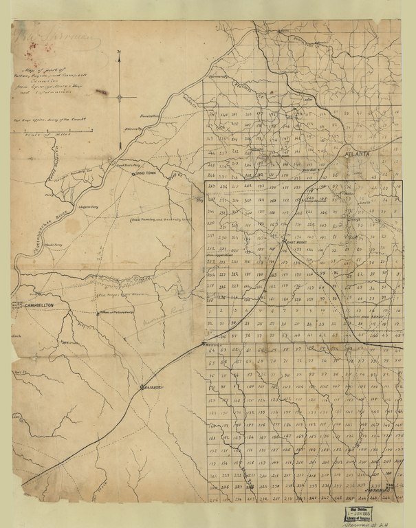
English: Relief shown by hachures. Differs from other 1864 ed. in abbreviation of title. Date from Stephenson's Civil War maps, 1989. LC Civil War maps (2nd ed.), S24, S25 Available also through the Library of Congress Web site as a raster image. Right half of map printed on 9/16 in. grid. Includes printed, opaque paper overlay (18 x 24 cm.) pasted onto right-center of map and covering the East Point/Rough & Ready area. Overlay includes geographic features in addition to those shown on original map. Includes names of select landowners and notes indicating general topography. Includes annotations in pencil. LC copy imperfect: Fold-lined, margins trimmed, minor losses along left edge, mounted on paper. |
||
| Title | Map of part of Fulton, Fayette, and Campbell counties, from surveys, state map, and information | ||
| Shelf ID | G3923.F8 1864 .U6 G3923.F8 1864 .U6 Copy 2 Vault : Sher 25 | ||
| Date | |||
| Source | https://www.loc.gov/item/2006458672/ | ||
| Author | United States. Army Of The Cumberland. Topographical Engineers Office | ||
| Permission (Reusing this file) |
|
||
| Other versions |
|
||
| Location | United States · Campbell County · Fulton County · Georgia · Fayette County | ||
| Part of | Civil War Maps · County Landownership Maps · Cultural Landscapes · Military Battles And Campaigns · Catalog · American Memory · Geography And Map Division | ||
| Subject | Georgia · Fayette County · Campbell County · Fayette County (Ga.) · United States · Maps · Fulton County · Fulton County (Ga.) · Campbell County (Ga.) · Landowners |


Licensing
[edit]|
This is a faithful photographic reproduction of a two-dimensional, public domain work of art. The work of art itself is in the public domain for the following reason:
The official position taken by the Wikimedia Foundation is that "faithful reproductions of two-dimensional public domain works of art are public domain".
This photographic reproduction is therefore also considered to be in the public domain in the United States. In other jurisdictions, re-use of this content may be restricted; see Reuse of PD-Art photographs for details. | ||||
File history
Click on a date/time to view the file as it appeared at that time.
| Date/Time | Thumbnail | Dimensions | User | Comment | |
|---|---|---|---|---|---|
| current | 06:11, 23 May 2018 |  | 5,520 × 7,008 (110.68 MB) | Fæ (talk | contribs) | LOC Maps https://www.loc.gov/item/2006458672/ #13603 |
You cannot overwrite this file.
File usage on Commons
The following page uses this file: