File:Map of part of New Holland showing the territory of Geelong and Dutigalla.png
Jump to navigation
Jump to search

Size of this preview: 473 × 599 pixels. Other resolutions: 189 × 240 pixels | 379 × 480 pixels | 607 × 768 pixels | 809 × 1,024 pixels | 2,396 × 3,033 pixels.
Original file (2,396 × 3,033 pixels, file size: 5.32 MB, MIME type: image/png)
Captions
Captions
Add a one-line explanation of what this file represents
Summary
[edit]
| Description |
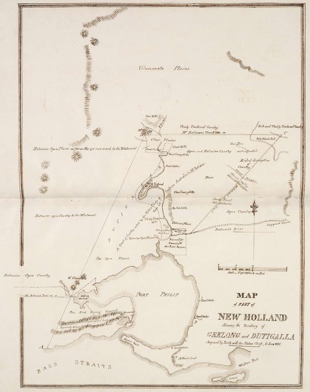
English: This is a map of the area which is now Melbourne and the Port Philip Bay in Australia, including the northerly Hinterland. The original map caption reads "MAP of PART of NEW HOLLAND Showing the Territory of GEELONG and DUTIGALLA Acquired by Treaty with the Native Chiefs, 6 June 1835." Scale: "Eight Miles to one Inch".
Deutsch: Diese Karte zeigt die Gegend des heutigen Melbourne mit der Port Philip Bay und dem nördlichen Hinterland. Der Original-Titel der Karte lautet: "KARTE eines TEILS von NEU-HOLLAND, Zeigend das Gebiet von GEELONG und DUTIGALLA, Erworben durch Vertrag mit den Eingeborenen Häuptlingen, 6. Juni 1835." Maßstab: "Acht Meilen zu einem Zoll". |
| Date | |
| Source | http://www.nma.gov.au/__data/assets/pdf_file/0010/19189/Map_of_part_of_New_Holland.pdf via http://www.nma.gov.au/engage-learn/schools/classroom-resources/multimedia/interactives/batmania_html_version/reaction |
| Author | Dixson Library, State Library of New South Wales, DL Q83/71 |
Licensing
[edit]
|
This work is in the public domain in its country of origin and other countries and areas where the copyright term is the author's life plus 100 years or fewer. | |
| This file has been identified as being free of known restrictions under copyright law, including all related and neighboring rights. | |
This image or other work is of Australian origin and is now in the public domain because its term of copyright has expired. According to the Australian Copyright Council (ACC), ACC Information Sheet G023v19 (Duration of copyright) (January 2019).1
When using this template, please provide information of where the image was first published and who created it. |
 | |||||||||||||||||||
| Annotations | This image is annotated: View the annotations at Commons |
File history
Click on a date/time to view the file as it appeared at that time.
| Date/Time | Thumbnail | Dimensions | User | Comment | |
|---|---|---|---|---|---|
| current | 01:07, 28 December 2013 | | 2,396 × 3,033 (5.32 MB) | Christallkeks (talk | contribs) | cropped |
| 00:58, 28 December 2013 |  | 2,835 × 3,492 (7.1 MB) | Christallkeks (talk | contribs) | {{Information |Description ={{en|1=This is a map of the area which is now Melbourne and the Port Philip Bay in Australia, including the northerly Hinterland. The original map caption reads "MAP of PART of NEW HOLLAND Showing the Territory of GEELONG... |
You cannot overwrite this file.
File usage on Commons
There are no pages that use this file.
File usage on other wikis
The following other wikis use this file:
- Usage on de.wikipedia.org
- Usage on en.wikipedia.org
- Usage on es.wikipedia.org
- Usage on pt.wikipedia.org