File:Map of part of eastern West Virginia, extending from Romney westward to Clarksburg, centering on the Rich Mountain Battle area. LOC 2005625002.tif
Jump to navigation
Jump to search

Size of this JPG preview of this TIF file: 376 × 599 pixels. Other resolutions: 150 × 240 pixels | 301 × 480 pixels | 482 × 768 pixels | 643 × 1,024 pixels | 1,286 × 2,048 pixels | 3,126 × 4,979 pixels.
Original file (3,126 × 4,979 pixels, file size: 44.53 MB, MIME type: image/tiff)
Captions
Captions
Add a one-line explanation of what this file represents
Summary
[edit]| Description |
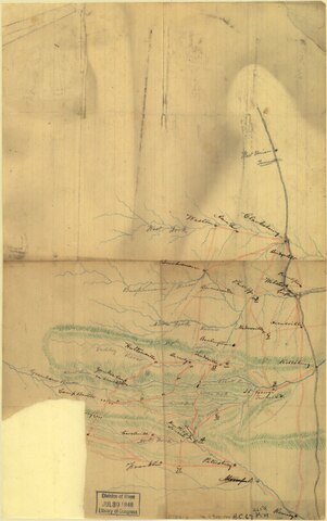
English: Shows "Camp Bartow" and "Yankee Camp on Cheat Mt." Relief shown by hachures. Title and date from Stephenson's Civil War maps, 1989. Pencil and colored pencil on lined paper, mounted between sheets of transparent paper. LC Civil War maps (2nd ed.), H67 Imperfect: Lower left corner is lacking, repaired tears in top left and right corners. Smudges and discoloration throughout. Available also through the Library of Congress web site as raster image. |
||
| Title | [Map of part of eastern West Virginia, extending from Romney westward to Clarksburg, centering on the Rich Mountain Battle area]. | ||
| Shelf ID | G3892.R5S5 1861 .M3 | ||
| Date | |||
| Source | https://www.loc.gov/item/2005625002/ | ||
| Author | Unknown author | ||
| Permission (Reusing this file) |
|
||
| Other versions |
|
||
| Location | Rich Mountain Region (Randolph County) · United States · Randolph County · Rich Mountain Region · West Virginia | ||
| Part of | Civil War Maps · Hotchkiss Map Collection · Military Battles And Campaigns · Catalog · American Memory · Geography And Map Division | ||
| Subject | Maps, Manuscript · Rich Mountain Region (Randolph County) · Rich Mountain Region (Randolph County, W. Va.) · Civil War · United States · West Virginia · History |


Licensing
[edit]|
This is a faithful photographic reproduction of a two-dimensional, public domain work of art. The work of art itself is in the public domain for the following reason:
The official position taken by the Wikimedia Foundation is that "faithful reproductions of two-dimensional public domain works of art are public domain".
This photographic reproduction is therefore also considered to be in the public domain in the United States. In other jurisdictions, re-use of this content may be restricted; see Reuse of PD-Art photographs for details. | ||||
File history
Click on a date/time to view the file as it appeared at that time.
| Date/Time | Thumbnail | Dimensions | User | Comment | |
|---|---|---|---|---|---|
| current | 05:04, 26 May 2018 |  | 3,126 × 4,979 (44.53 MB) | Fæ (talk | contribs) | LOC Maps https://www.loc.gov/item/2005625002/ #1581 |
You cannot overwrite this file.
File usage on Commons
The following 3 pages use this file:
- File:(Map of part of eastern West Virginia, extending from Romney westward to Clarksburg, centering on the Rich Mountain Battle area). LOC 2005625002.tif (file redirect)
- File:Map of part of eastern West Virginia, extending from Romney westward to Clarksburg, centering on the Rich Mountain Battle area. LOC 2005625002.jpg