File:Map of the battlefield of Chickamauga, September 19th and 20th 1863. LOC 99447314-11.tif
Jump to navigation
Jump to search

Size of this JPG preview of this TIF file: 800 × 494 pixels. Other resolutions: 320 × 197 pixels | 640 × 395 pixels | 1,024 × 632 pixels | 1,280 × 790 pixels | 2,560 × 1,579 pixels | 11,063 × 6,825 pixels.
Original file (11,063 × 6,825 pixels, file size: 216.02 MB, MIME type: image/tiff)
Captions
Captions
Add a one-line explanation of what this file represents
Summary
[edit]| Description |
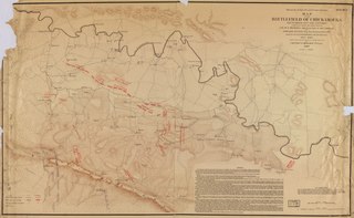
English: LC Civil War Maps (2nd ed.), S191, 159 Maps are loose in two folders entitled "Chickamauga, Sept. 19th and 20th 1863." The folder for the "First day" includes "Sheet no. A: Preliminary movements, Sept. 18th" and sheets 1 to 4. The "Second day" folder contains sheets 5 to 8 and "Sheet no. Z: Movements of Sept. 21st and 22nd (after the battle)." Each map gives troop positions and movements, names of commanding officers, a legend describing the action depicted, roads, houses, names of residents, fences, relief by hachures, vegetation, draimage, and fords. Copy 1 folders are stamped "Library of Congress, City of Washington, Copyright Oct. 24, 1892." Description derived from published bibliography. Available also through the Library of Congress web site as raster image. |
||
| Title | Map of the battlefield of Chickamauga, September 19th and 20th 1863. | ||
| Shelf ID | G3922.C52S5 1892 .R9 G3922.C52S5 1892 .R9 Vault : Sher 191 Copy 4 | ||
| Parent | https://www.loc.gov/resource/g3922cm.gcws0191/ | ||
| Sheet title | Sheet no. Z | ||
| Date | |||
| Source | https://www.loc.gov/item/99447314/ | ||
| Author | Ruger, Edward | ||
| Permission (Reusing this file) |
|
||
| Other versions |
|
||
| Location | United States · Chickamauga Battlefield · Georgia | ||
| Part of | Military Battles And Campaigns · American Memory · Civil War Maps · Catalog · Geography And Map Division | ||
| Subject | Georgia · Chickamauga, Battle Of, Ga. · Chickamauga, Battle Of, Ga · United States · Maps · Chickamauga Battlefield (Ga.) · Chickamauga Battlefield |


Licensing
[edit]|
This is a faithful photographic reproduction of a two-dimensional, public domain work of art. The work of art itself is in the public domain for the following reason:
The official position taken by the Wikimedia Foundation is that "faithful reproductions of two-dimensional public domain works of art are public domain".
This photographic reproduction is therefore also considered to be in the public domain in the United States. In other jurisdictions, re-use of this content may be restricted; see Reuse of PD-Art photographs for details. | ||||
File history
Click on a date/time to view the file as it appeared at that time.
| Date/Time | Thumbnail | Dimensions | User | Comment | |
|---|---|---|---|---|---|
| current | 13:20, 23 May 2019 |  | 11,063 × 6,825 (216.02 MB) | Fæ (talk | contribs) | LOC Maps multisheet https://www.loc.gov/item/99447314/ sheet 11 of 11 #8676 |
You cannot overwrite this file.
File usage on Commons
The following 2 pages use this file: