File:Map of the route of Edward III's chevauchée of 1346.svg
Перейти к навигации
Перейти к поиску

Размер этого PNG-превью для исходного SVG-файла: 643 × 600 пкс. Другие разрешения: 257 × 240 пкс | 515 × 480 пкс | 823 × 768 пкс | 1098 × 1024 пкс | 2195 × 2048 пкс | 1059 × 988 пкс.
Исходный файл (SVG-файл, номинально 1059 × 988 пкс, размер файла: 450 КБ)
Краткие подписи
Краткие подписи
Добавьте однострочное описание того, что собой представляет этот файл
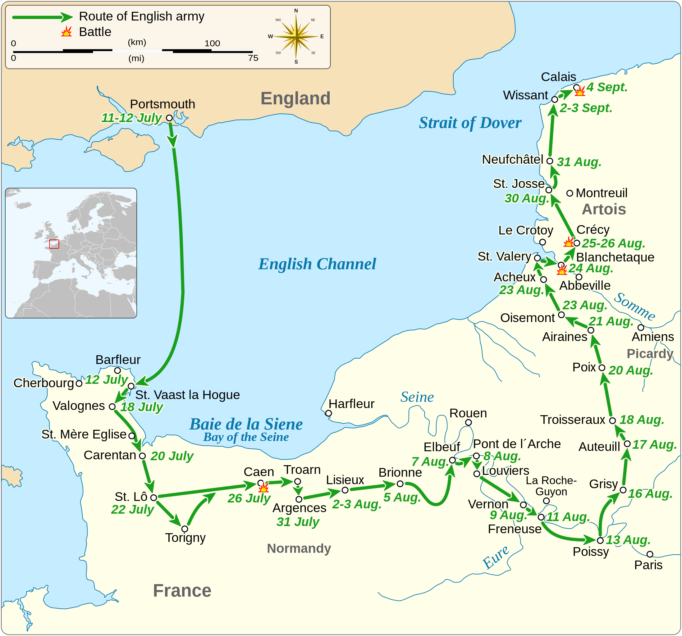
Map of the route of Edward III's chevauchée of 1346, part of the Hundred Years' War
Краткое описание[править]
| Описание |
English: Map of the route of Edward III's chevauchée of 1346, part of the Hundred Years' War. This map shows the English army movements during the campaign and the most important battles.
|
||||||||||||||||||||||||||||||||||||||||||||||||||||||||||
| Дата | |||||||||||||||||||||||||||||||||||||||||||||||||||||||||||
| Источник |
Собственная работа Derived from; Information from:
|
||||||||||||||||||||||||||||||||||||||||||||||||||||||||||
| Автор | Goran tek-en | ||||||||||||||||||||||||||||||||||||||||||||||||||||||||||
| Права (Повторное использование этого файла) |
Этот файл доступен по лицензии Creative Commons Attribution-Share Alike 4.0 International Атрибуция: Goran tek-en
|
||||||||||||||||||||||||||||||||||||||||||||||||||||||||||
| SVG‑разработка | Это векторное изображение было создано с помощью Inkscape. |
||||||||||||||||||||||||||||||||||||||||||||||||||||||||||


| Местоположение объекта | | Это и другие изображения по их местоположению на OpenStreetMap |
|---|


История файла
Нажмите на дату/время, чтобы увидеть версию файла от того времени.
| Дата/время | Миниатюра | Размеры | Участник | Примечание | |
|---|---|---|---|---|---|
| текущий | 00:14, 3 февраля 2022 | | 1059 × 988 (450 КБ) | Iso10970 (обсуждение | вклад) | Reverted to version as of 13:17, 9 November 2021 (UTC) |
| 00:13, 3 февраля 2022 |  | 1059 × 988 (614 КБ) | Iso10970 (обсуждение | вклад) | File uploaded using svgtranslate tool (https://svgtranslate.toolforge.org/). Added translation for ja. | |
| 13:17, 9 ноября 2021 |  | 1059 × 988 (450 КБ) | Goran tek-en (обсуждение | вклад) | Changed view box, font size, added location map | |
| 13:06, 14 апреля 2019 |  | 1059 × 988 (191 КБ) | Goran tek-en (обсуждение | вклад) | Spelling | |
| 17:53, 10 марта 2019 |  | 1059 × 988 (115 КБ) | JoKalliauer (обсуждение | вклад) | phab:T36947 bad character aligment on same sizes | |
| 14:08, 6 марта 2019 |  | 1059 × 988 (191 КБ) | Goran tek-en (обсуждение | вклад) | {{Information |description ={{en|1=Map of the route of Edward III's chevauchée of 1346, part of the Hundred Years' War. This map shows the English army movements during the campaign and the most important battles.}} |date =20190306 |source ={{Own}}<br> Derived from; * [https://www.openstreetmap.org/#map=8/49.919/1.371 OSM] Information from: * [https://www.themaparchive.com/the-crecy-campaign-12-july-to-4-september-1346.html themaparchive.com] * {{U|Newm30}} |author... |
Вы не можете перезаписать этот файл.
Использование файла
Следующие 8 страниц используют этот файл:
- User:Goran tek-en/Gallery/2019
- User:Magog the Ogre/Maps of conflicts/2019 April
- User:Magog the Ogre/Maps of conflicts/2019 March
- User:Magog the Ogre/Maps of conflicts/2021 November
- User:Magog the Ogre/Maps of conflicts/2022 February
- File:Map of Gascon campaign of 1345.svg
- File:Map of route of Black Prince chevauchée of 1355.svg
- File:Map of route of Lancaster's chevauchée of 1346.svg
Глобальное использование файла
Данный файл используется в следующих вики:
- Использование в cs.wikipedia.org
- Использование в en.wikipedia.org
- Использование в es.wikipedia.org
- Использование в fi.wikipedia.org
- Использование в fr.wikipedia.org
- Использование в hu.wikipedia.org
- Использование в ja.wikipedia.org
- Использование в nl.wikipedia.org
- Использование в pt.wikipedia.org
- Использование в ru.wikipedia.org
- Использование в sh.wikipedia.org
- Использование в tr.wikipedia.org
- Использование в zh.wikipedia.org