File:Map provinces Netherlands-en.svg
跳至導覽
跳至搜尋

此 SVG 檔案的 PNG 預覽的大小:506 × 600 像素。 其他解析度:202 × 240 像素 | 405 × 480 像素 | 648 × 768 像素 | 864 × 1,024 像素 | 1,727 × 2,048 像素 | 743 × 881 像素。
原始檔案 (SVG 檔案,表面大小:743 × 881 像素,檔案大小:1,003 KB)
說明
說明
添加單行說明來描述出檔案所代表的內容
本vector image使用Inkscape創作 .

|
This SVG file contains embedded text that can be translated into your language, using any capable SVG editor, text editor or the SVG Translate tool. For more information see: About translating SVG files. |
摘要
[編輯]| 描述 |
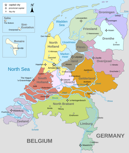
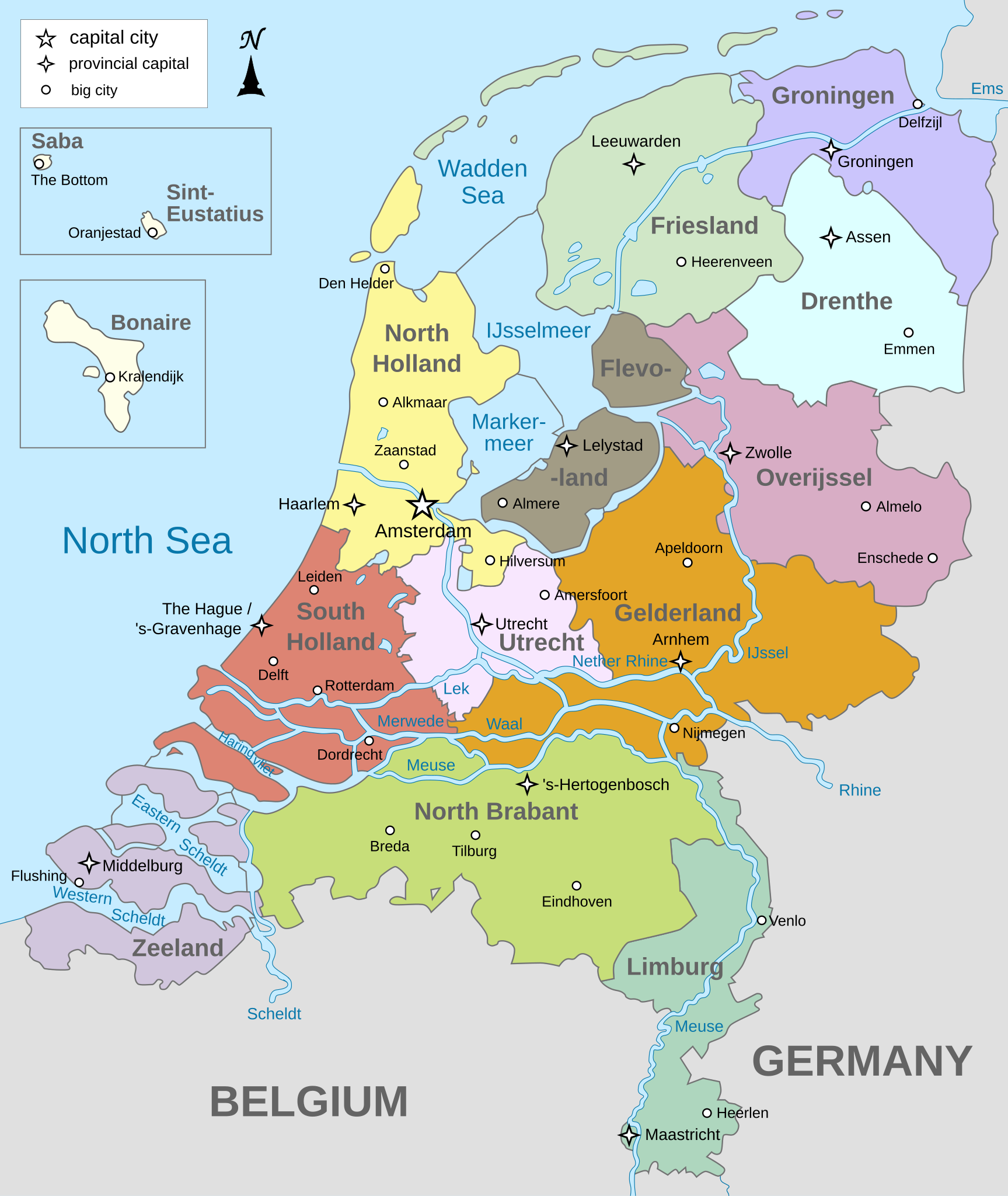
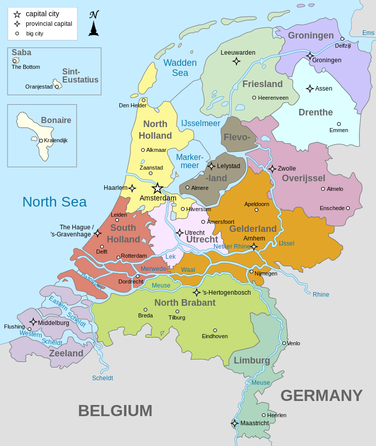
English: Map of The Netherlands (including the special municipalities of Saba, Saint Eustatius and Bonaire; the Caribbean Netherlands), showing provinces, large cities, rivers and lakes. English version
Deutsch: Karte der Niederlande, mit den Provinzen, der Karibischen Niederlande, den Großstädten und den Flüssen und Seen. Englische Version
Bahasa Indonesia: Peta Belanda (termasuk munisipal khusus Saba, Saint Eustatius dan Bonaire; Belanda Karibia), menampilkan provinsi, kota besar, sungai dan danau. Versi bahasa Inggris |
| 日期 | |
| 來源 | 自己的作品 |
| 作者 | Alphathon |
| 其他版本 |
[]
|


.svg)
授權條款
[編輯]
我,本作品的著作權持有者,決定用以下授權條款發佈本作品:
此檔案採用創用CC 姓名標示-相同方式分享 3.0 未在地化版本授權條款。
- 您可以自由:
- 分享 – 複製、發佈和傳播本作品
- 重新修改 – 創作演繹作品
- 惟需遵照下列條件:
- 姓名標示 – 您必須指名出正確的製作者,和提供授權條款的連結,以及表示是否有對內容上做出變更。您可以用任何合理的方式來行動,但不得以任何方式表明授權條款是對您許可或是由您所使用。
- 相同方式分享 – 如果您利用本素材進行再混合、轉換或創作,您必須基於如同原先的相同或兼容的條款,來分布您的貢獻成品。

|
已授權您依據自由軟體基金會發行的無固定段落、封面文字和封底文字GNU自由文件授權條款1.2版或任意後續版本,對本檔進行複製、傳播和/或修改。該協議的副本列在GNU自由文件授權條款中。 |
您可以選擇您需要的授權條款。
檔案歷史
點選日期/時間以檢視該時間的檔案版本。
| 日期/時間 | 縮圖 | 尺寸 | 使用者 | 備註 | |
|---|---|---|---|---|---|
| 目前 | 2024年1月19日 (五) 19:28 | | 743 × 881(1,003 KB) | Illchy(留言 | 貢獻) | File uploaded using svgtranslate tool (https://svgtranslate.toolforge.org/). Added translation for id. |
| 2023年4月29日 (六) 17:43 |  | 743 × 881(987 KB) | Dymitr(留言 | 貢獻) | File uploaded using svgtranslate tool (https://svgtranslate.toolforge.org/). Added translation for be-tarask. | |
| 2021年11月25日 (四) 09:27 |  | 743 × 881(909 KB) | Andrei Stroe(留言 | 貢獻) | File uploaded using svgtranslate tool (https://svgtranslate.toolforge.org/). Added translation for ro. | |
| 2019年4月12日 (五) 08:39 |  | 743 × 881(811 KB) | Thayts(留言 | 貢獻) | Tweaked text position | |
| 2019年2月17日 (日) 11:32 |  | 743 × 881(811 KB) | Thayts(留言 | 貢獻) | Fixed svg | |
| 2019年2月17日 (日) 11:18 |  | 743 × 881(811 KB) | Thayts(留言 | 貢獻) | Added a bit more spacing between Eastern/Western and Scheldt | |
| 2019年2月17日 (日) 11:06 |  | 743 × 881(811 KB) | Thayts(留言 | 貢獻) | Fixed Eastern Scheldt which wasn't rendered by the MediaWiki engine; removed Belgian city of Antwerp | |
| 2019年2月14日 (四) 05:21 |  | 743 × 881(809 KB) | Alphathon(留言 | 貢獻) | Updated borders | |
| 2015年8月23日 (日) 20:34 |  | 743 × 881(847 KB) | Alphathon(留言 | 貢獻) | Fixed stroke weight on a Friesland lake | |
| 2015年8月23日 (日) 20:27 |  | 743 × 881(847 KB) | Alphathon(留言 | 貢獻) | Covered over the strokes at the mouths of rivers |
無法覆蓋此檔案。
檔案用途
下列23個頁面有用到此檔案:
- Atlas of the Netherlands
- User:Magog the Ogre/Multilingual legend/2021 November 21-30
- User:Magog the Ogre/Multilingual legend/2023 April 21-30
- User:Magog the Ogre/Multilingual legend/2024 January 17-21
- File:Map of the Netherlands.svg
- File:Map provinces Netherlands-de.svg
- File:Map provinces Netherlands-el.svg
- File:Map provinces Netherlands-en.svg
- File:Map provinces Netherlands-es.svg
- File:Map provinces Netherlands-fr.svg
- File:Map provinces Netherlands-fy.svg
- File:Map provinces Netherlands-he.svg
- File:Map provinces Netherlands-it.svg
- File:Map provinces Netherlands-ja.svg
- File:Map provinces Netherlands-mk.svg
- File:Map provinces Netherlands-nl.svg
- File:Netherlands Map.svg (檔案重新導向)
- File:Netherlands Map (Without Islands).svg
- File:Netherlands map large-10-10-10.png
- File:Netherlands map large.png
- File:Netherlands map small.png
- Template:Other versions/Map provinces Netherlands
全域檔案使用狀況
以下其他 wiki 使用了這個檔案:
- ace.wikipedia.org 的使用狀況
- af.wikipedia.org 的使用狀況
- ang.wikipedia.org 的使用狀況
- an.wikipedia.org 的使用狀況
- ar.wikipedia.org 的使用狀況
- ay.wikipedia.org 的使用狀況
- azb.wikipedia.org 的使用狀況
- be-tarask.wikipedia.org 的使用狀況
- bg.wikipedia.org 的使用狀況
- blk.wikipedia.org 的使用狀況
- bn.wikipedia.org 的使用狀況
- ceb.wikipedia.org 的使用狀況
- diq.wikipedia.org 的使用狀況
- en.wikipedia.org 的使用狀況
- Netherlands
- Provinces of the Netherlands
- List of islands of the Netherlands
- King's commissioner
- Geology of the Netherlands
- File talk:Netherlands map large.png
- French war planning 1920–1940
- User talk:Gidonb/Archive 2008
- Template:Provinces of the Netherlands imagemap
- List of windmills in the Netherlands
- Provincial politics in the Netherlands
- 2008–09 KNVB Cup
- User:Alphathon/Gallery
- Portal:Islands
- Wikipedia:Reference desk/Archives/Humanities/2014 September 25
- en.wikiversity.org 的使用狀況
- eu.wikipedia.org 的使用狀況
- fa.wikipedia.org 的使用狀況
- fi.wikipedia.org 的使用狀況
- fr.wikipedia.org 的使用狀況
- gl.wikipedia.org 的使用狀況
- haw.wikipedia.org 的使用狀況
- he.wikipedia.org 的使用狀況
- ia.wikipedia.org 的使用狀況
- id.wikipedia.org 的使用狀況
檢視此檔案的更多全域使用狀況。