File:Map provinces Netherlands-mk.svg
Jump to navigation
Jump to search

Size of this PNG preview of this SVG file: 506 × 600 pixels. Other resolutions: 202 × 240 pixels | 405 × 480 pixels | 648 × 768 pixels | 864 × 1,024 pixels | 1,727 × 2,048 pixels | 743 × 881 pixels.
Original file (SVG file, nominally 743 × 881 pixels, file size: 1.31 MB)
Captions
Captions
Add a one-line explanation of what this file represents
Summary[edit]
| Description |
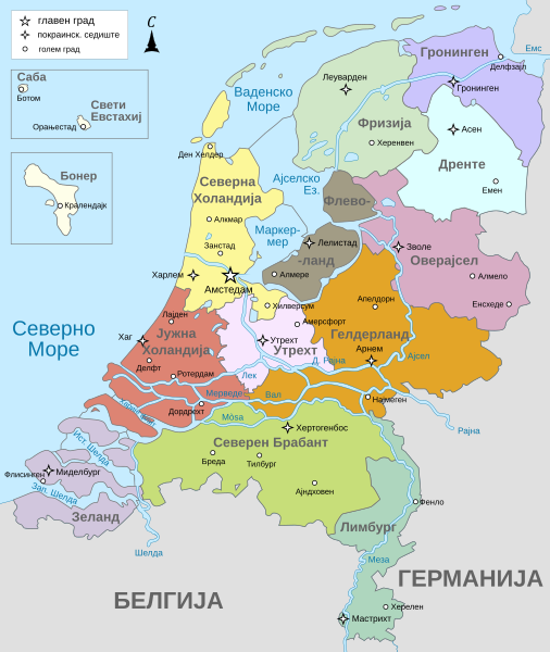
Македонски: Карта на покраините и поважните градови во Холандија.
English: Map of the provinces and larger cities in the Netherlands in Macedonian. |
| Date | |
| Source | File:Map provinces Netherlands-nl.svg |
| Author |
Alphathon & Bibi Saint-Pol derivative by B. Jankuloski |
| Other versions |
[]
|


.svg)
Licensing[edit]
This file is licensed under the Creative Commons Attribution-Share Alike 4.0 International license.
- You are free:
- to share – to copy, distribute and transmit the work
- to remix – to adapt the work
- Under the following conditions:
- attribution – You must give appropriate credit, provide a link to the license, and indicate if changes were made. You may do so in any reasonable manner, but not in any way that suggests the licensor endorses you or your use.
- share alike – If you remix, transform, or build upon the material, you must distribute your contributions under the same or compatible license as the original.
File history
Click on a date/time to view the file as it appeared at that time.
| Date/Time | Thumbnail | Dimensions | User | Comment | |
|---|---|---|---|---|---|
| current | 01:01, 13 September 2023 | | 743 × 881 (1.31 MB) | Bjankuloski06 (talk | contribs) | Uploaded a work by Alphathon & Bibi Saint-Pol<br>derivative by B. Jankuloski from File:Map provinces Netherlands-nl.svg with UploadWizard |
You cannot overwrite this file.
File usage on Commons
The following 13 pages use this file:
- File:Map provinces Netherlands-de.svg
- File:Map provinces Netherlands-el.svg
- File:Map provinces Netherlands-en.svg
- File:Map provinces Netherlands-es.svg
- File:Map provinces Netherlands-fr.svg
- File:Map provinces Netherlands-fy.svg
- File:Map provinces Netherlands-he.svg
- File:Map provinces Netherlands-it.svg
- File:Map provinces Netherlands-ja.svg
- File:Map provinces Netherlands-mk.svg
- File:Map provinces Netherlands-nl.svg
- File:Netherlands Map (Without Islands).svg
- Template:Other versions/Map provinces Netherlands
File usage on other wikis
The following other wikis use this file:
- Usage on mk.wikipedia.org