File:Map showing the percentage of Jews in the Pale of Settlement and Congress Poland, The Jewish Encyclopedia (1905).jpg
Salta a la navegació
Salta a la cerca

Mida d'aquesta previsualització: 453 × 599 píxels. Altres resolucions: 181 × 240 píxels | 363 × 480 píxels | 580 × 768 píxels | 774 × 1.024 píxels | 1.548 × 2.048 píxels | 3.404 × 4.504 píxels.
Fitxer original (3.404 × 4.504 píxels, mida del fitxer: 1,01 Mo, tipus MIME: image/jpeg)
Llegendes
Llegendes
Afegeix una explicació d'una línia del que representa aquest fitxer
Resum[modifica]
| Descripció |
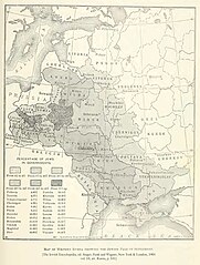
English: Map showing the percentage of Jews in the Pale of Settlement and Congress Poland (Original caption without the red line).
|
| Data | |
| Font | Herman Rosenthal; J.G. Lipman; Vasili Rosenthal; L. Wygodsky; M. Mysh; Abraham Galante (1905) «Russia» en The Jewish Encyclopedia: Vol. 10, Philipson–Samoscz, New York, N.Y.: Funk & Wagnalls, p. 531 |
| Autor | Not specified in source. |
| Altres versions |
|


.jpg&action=edit§ion=1)
Llicència[modifica]
.jpg&action=edit§ion=2)
This image is in the public domain because it was part of Jewish Encyclopedia (1901–1906). The copyrights for that book have expired and this image is in the public domain.
|
 | |
This work is in the public domain in the United States because it was published (or registered with the U.S. Copyright Office) before January 1, 1929.
|
Historial del fitxer
Cliqueu una data/hora per veure el fitxer tal com era aleshores.
.jpg&uselang=ca&dir=prev)
.jpg&uselang=ca&offset=20170930195942)
.jpg&uselang=ca&offset=&limit=20)
.jpg&uselang=ca&offset=&limit=50)
.jpg&uselang=ca&offset=&limit=100)
.jpg&uselang=ca&offset=&limit=250)
.jpg&uselang=ca&offset=&limit=500)
| Data/hora | Miniatura | Dimensions | Usuari/a | Comentari | |
|---|---|---|---|---|---|
| actual | 09:54, 12 ago 2020 | | 3.404 × 4.504 (1,01 Mo) | Valp (discussió | contribucions) | Same as the previous one, but cropped and souce added between [ ] at the bottom |
| 09:49, 12 ago 2020 |  | 3.626 × 5.642 (1,28 Mo) | Valp (discussió | contribucions) | High definition (3404 x 4504) of the original, scanned from the printed edition for Archive.org | |
| 09:42, 30 ago 2018 |  | 530 × 642 (115 Ko) | Nihil scimus (discussió | contribucions) | Original version as of 10:26, 16 November 2005 (UTC) | |
| 09:41, 30 ago 2018 |  | 447 × 366 (211 Ko) | Nihil scimus (discussió | contribucions) | Since the concordant sources & similar maps, easier to read and without controversed changes | |
| 07:28, 11 nov 2017 |  | 530 × 642 (168 Ko) | Mathiasrex (discussió | contribucions) | Reverted to version as of 19:59, 30 September 2017 (UTC) cause Congress Poland was not a part of Pale of Settlement | |
| 18:07, 3 nov 2017 |  | 533 × 646 (364 Ko) | Claude Zygiel (discussió | contribucions) | The Pale of Settlement was an Eastern limit (red). The Western one was the border of the Russian Empire (green). | |
| 17:54, 3 nov 2017 |  | 530 × 642 (115 Ko) | Claude Zygiel (discussió | contribucions) | Reverted to version as of 17:31, 21 October 2017 (UTC) | |
| 18:56, 2 nov 2017 |  | 530 × 642 (168 Ko) | Sandstein (discussió | contribucions) | No idea who's right, but don't omit the red line, it highlights the area | |
| 17:31, 21 oct 2017 |  | 530 × 642 (115 Ko) | MAXHO (discussió | contribucions) | To avoid editing conflicts, reverted to version as of 10:26, 16 November 2005 (UTC): Poland has a jewish population ! | |
| 19:59, 30 set 2017 |  | 530 × 642 (168 Ko) | Mathiasrex (discussió | contribucions) | Reverted to version as of 12:48, 9 October 2010 (UTC) Cingress Poland was not a part of Pale of Settlement |
No podeu sobreescriure aquest fitxer.
Ús del fitxer
Les 11 pàgines següents utilitzen aquest fitxer:
- User:Geagea/Israel/2017 November 11
- User:Geagea/Israel/2017 November 2
- User:Geagea/Israel/2017 November 3
- User:Geagea/Israel/2017 October 21
- User:Geagea/Israel/2017 September 24
- User:Geagea/Israel/2017 September 30
- User talk:Sheynhertz-Unbayg~commonswiki/sandbox
- File:Map showing percentage of Jews in the Pale of Settlement and Congress Poland, c. 1905.png
- File:Pale of Settlement map.jpg (fitxer redirigit)
- Category:Pale of Settlement
Ús global del fitxer
Utilització d'aquest fitxer en altres wikis:
- Utilització a af.wikipedia.org
- Utilització a ar.wikipedia.org
- Utilització a ast.wikipedia.org
- Utilització a azb.wikipedia.org
- Utilització a be-tarask.wikipedia.org
- Utilització a be.wikipedia.org
- Utilització a bg.wikipedia.org
- Utilització a ca.wikipedia.org
- Utilització a cs.wikipedia.org
- Utilització a cy.wikipedia.org
- Utilització a da.wikipedia.org
- Utilització a el.wikipedia.org
- Utilització a en.wikipedia.org
- Utilització a eo.wikipedia.org
- Utilització a et.wikipedia.org
- Utilització a eu.wikipedia.org
- Utilització a fr.wikipedia.org
- Utilització a ga.wikipedia.org
- Utilització a gl.wikipedia.org
- Utilització a he.wikipedia.org
- Utilització a hu.wikipedia.org
- Utilització a id.wikipedia.org
- Utilització a it.wikipedia.org
- Utilització a it.wikibooks.org
- Utilització a krc.wikipedia.org
- Utilització a lt.wikipedia.org
- Utilització a lv.wikipedia.org
- Utilització a nl.wikipedia.org
- Utilització a nn.wikipedia.org
- Utilització a no.wikipedia.org
- Utilització a pl.wikipedia.org
Vegeu més usos globals d'aquest fitxer.
.jpg)
.jpg&oldid=732633832)