File:Map showing the percentage of Jews in the Pale of Settlement and Congress Poland, The Jewish Encyclopedia (1905).jpg
Aller à la navigation
Aller à la recherche

Taille de cet aperçu : 453 × 599 pixels. Autres résolutions : 181 × 240 pixels | 363 × 480 pixels | 580 × 768 pixels | 774 × 1 024 pixels | 1 548 × 2 048 pixels | 3 404 × 4 504 pixels.
Fichier d’origine (3 404 × 4 504 pixels, taille du fichier : 1,01 Mio, type MIME : image/jpeg)
Légendes
Légendes
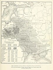
Zone de Résidence telle qu'en 1901 montrant le pourcentage de population juive (Jewish Encyclopedia, vol. 10,, art. Russia, p. 531)
Description[modifier]
| Description |
English: Map showing the percentage of Jews in the Pale of Settlement and Congress Poland (Original caption without the red line).
|
| Date | |
| Source | Herman Rosenthal; J.G. Lipman; Vasili Rosenthal; L. Wygodsky; M. Mysh; Abraham Galante (1905) «Russia» dans The Jewish Encyclopedia: Vol. 10, Philipson–Samoscz, New York, N.Y. : Funk & Wagnalls, pp. 531 |
| Auteur | Not specified in source. |
| Autres versions |
|


.jpg&action=edit§ion=1)
Conditions d’utilisation[modifier]
.jpg&action=edit§ion=2)
Cette image est dans le domaine public parce qu'elle faisait partie de la Jewish Encyclopedia (1901-1906). Le copyright a expiré pour cet ouvrage et cette image est donc dans le domaine public.
|
 | |
Cette œuvre est dans le domaine public aux États-Unis car elle a été publiée avant le 1er janvier 1929.
|
Historique du fichier
Cliquer sur une date et heure pour voir le fichier tel qu'il était à ce moment-là.
.jpg&uselang=fr&dir=prev)
.jpg&uselang=fr&offset=20170930195942)
.jpg&uselang=fr&offset=&limit=20)
.jpg&uselang=fr&offset=&limit=50)
.jpg&uselang=fr&offset=&limit=100)
.jpg&uselang=fr&offset=&limit=250)
.jpg&uselang=fr&offset=&limit=500)
| Date et heure | Vignette | Dimensions | Utilisateur | Commentaire | |
|---|---|---|---|---|---|
| actuel | 12 août 2020 à 09:54 | | 3 404 × 4 504 (1,01 Mio) | Valp (d | contributions) | Same as the previous one, but cropped and souce added between [ ] at the bottom |
| 12 août 2020 à 09:49 |  | 3 626 × 5 642 (1,28 Mio) | Valp (d | contributions) | High definition (3404 x 4504) of the original, scanned from the printed edition for Archive.org | |
| 30 août 2018 à 09:42 |  | 530 × 642 (115 kio) | Nihil scimus (d | contributions) | Original version as of 10:26, 16 November 2005 (UTC) | |
| 30 août 2018 à 09:41 |  | 447 × 366 (211 kio) | Nihil scimus (d | contributions) | Since the concordant sources & similar maps, easier to read and without controversed changes | |
| 11 novembre 2017 à 07:28 |  | 530 × 642 (168 kio) | Mathiasrex (d | contributions) | Reverted to version as of 19:59, 30 September 2017 (UTC) cause Congress Poland was not a part of Pale of Settlement | |
| 3 novembre 2017 à 18:07 |  | 533 × 646 (364 kio) | Claude Zygiel (d | contributions) | The Pale of Settlement was an Eastern limit (red). The Western one was the border of the Russian Empire (green). | |
| 3 novembre 2017 à 17:54 |  | 530 × 642 (115 kio) | Claude Zygiel (d | contributions) | Reverted to version as of 17:31, 21 October 2017 (UTC) | |
| 2 novembre 2017 à 18:56 |  | 530 × 642 (168 kio) | Sandstein (d | contributions) | No idea who's right, but don't omit the red line, it highlights the area | |
| 21 octobre 2017 à 17:31 |  | 530 × 642 (115 kio) | MAXHO (d | contributions) | To avoid editing conflicts, reverted to version as of 10:26, 16 November 2005 (UTC): Poland has a jewish population ! | |
| 30 septembre 2017 à 19:59 |  | 530 × 642 (168 kio) | Mathiasrex (d | contributions) | Reverted to version as of 12:48, 9 October 2010 (UTC) Cingress Poland was not a part of Pale of Settlement |
Vous ne pouvez pas remplacer ce fichier.
Utilisations locales du fichier
Les 11 pages suivantes utilisent ce fichier :
- User:Geagea/Israel/2017 November 11
- User:Geagea/Israel/2017 November 2
- User:Geagea/Israel/2017 November 3
- User:Geagea/Israel/2017 October 21
- User:Geagea/Israel/2017 September 24
- User:Geagea/Israel/2017 September 30
- User talk:Sheynhertz-Unbayg~commonswiki/sandbox
- File:Map showing percentage of Jews in the Pale of Settlement and Congress Poland, c. 1905.png
- File:Pale of Settlement map.jpg (redirection de fichier)
- Category:Pale of Settlement
Utilisations du fichier sur d’autres wikis
Les autres wikis suivants utilisent ce fichier :
- Utilisation sur af.wikipedia.org
- Utilisation sur ar.wikipedia.org
- Utilisation sur ast.wikipedia.org
- Utilisation sur azb.wikipedia.org
- Utilisation sur be-tarask.wikipedia.org
- Utilisation sur be.wikipedia.org
- Utilisation sur bg.wikipedia.org
- Utilisation sur ca.wikipedia.org
- Utilisation sur cs.wikipedia.org
- Utilisation sur cy.wikipedia.org
- Utilisation sur da.wikipedia.org
- Utilisation sur el.wikipedia.org
- Utilisation sur en.wikipedia.org
- Utilisation sur eo.wikipedia.org
- Utilisation sur et.wikipedia.org
- Utilisation sur eu.wikipedia.org
- Utilisation sur fr.wikipedia.org
- Utilisation sur ga.wikipedia.org
- Utilisation sur gl.wikipedia.org
- Utilisation sur he.wikipedia.org
- Utilisation sur hu.wikipedia.org
- Utilisation sur id.wikipedia.org
- Utilisation sur it.wikipedia.org
- Utilisation sur it.wikibooks.org
- Utilisation sur krc.wikipedia.org
- Utilisation sur lt.wikipedia.org
- Utilisation sur lv.wikipedia.org
- Utilisation sur nl.wikipedia.org
- Utilisation sur nn.wikipedia.org
- Utilisation sur no.wikipedia.org
- Utilisation sur pl.wikipedia.org
Voir davantage sur l’utilisation globale de ce fichier.
.jpg)
.jpg&oldid=732633832)