File:Mapa Rhinella atacamensis.svg
Jump to navigation
Jump to search

Size of this PNG preview of this SVG file: 270 × 600 pixels. Other resolutions: 108 × 240 pixels | 216 × 480 pixels | 345 × 768 pixels | 461 × 1,024 pixels | 921 × 2,048 pixels | 288 × 640 pixels.
Original file (SVG file, nominally 288 × 640 pixels, file size: 996 KB)
Captions
Captions
Add a one-line explanation of what this file represents
| Description |
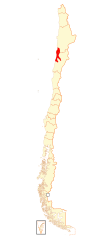
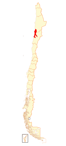
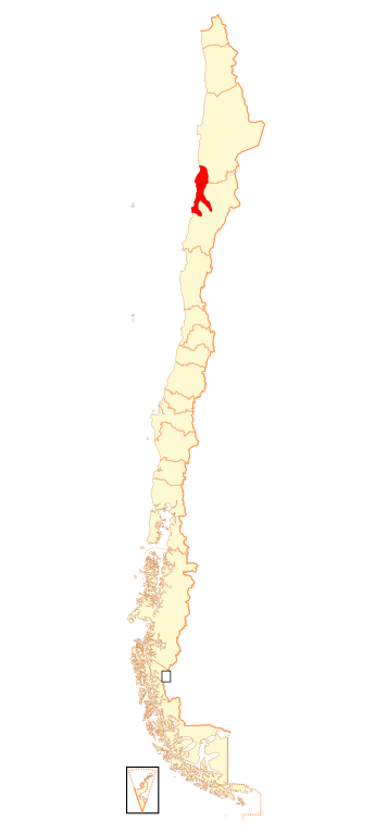
Español: Mapa de Rhinella atacamensis |
| Date | (UTC) |
| Source | |
| Author |
|
| This is a retouched picture, which means that it has been digitally altered from its original version. Modifications: agrego zona de distribución. The original can be viewed here: Mapa Regiones de Chile.svg:
|

This file is licensed under the Creative Commons Attribution-Share Alike 3.0 Unported license.
Attribution: IUCN Red List of Threatened Species, species assessors and the authors of the spatial data.
- You are free:
- to share – to copy, distribute and transmit the work
- to remix – to adapt the work
- Under the following conditions:
- attribution – You must give appropriate credit, provide a link to the license, and indicate if changes were made. You may do so in any reasonable manner, but not in any way that suggests the licensor endorses you or your use.
- share alike – If you remix, transform, or build upon the material, you must distribute your contributions under the same or compatible license as the original.
Original upload log
[edit]
This image is a derivative work of the following images:
- File:Mapa_Regiones_de_Chile.svg licensed with Cc-by-sa-3.0,2.5,2.0,1.0, GFDL
- 2009-01-16T20:50:58Z Carlos yo 270x600 (1039852 Bytes) {{Information |Description={{es|1=Mapa de Chile, dividido en regiones.}} |Source=trabajo propio (own work), basado en [[:Image:Mapa Institutos Teletón.svg]] |Author=[[User:Carlos yo|Carlos yo]] |Date=2009-16-1 |Permission= |
Uploaded with derivativeFX
File history
Click on a date/time to view the file as it appeared at that time.
| Date/Time | Thumbnail | Dimensions | User | Comment | |
|---|---|---|---|---|---|
| current | 20:41, 18 August 2018 | | 288 × 640 (996 KB) | Janitoalevic (talk | contribs) | Ñuble |
| 14:55, 4 March 2009 |  | 270 × 600 (1,018 KB) | Ignacio Rodríguez (talk | contribs) | {{Information |Description={{es|1=Mapa de Rhinella atacamensis}} |Source=*File:Mapa_Regiones_de_Chile.svg |Date=2009-03-04 14:54 (UTC) |Author=*File:Mapa_Regiones_de_Chile.svg: Carlos yo *derivative work: ~~~ |Permission=see |
You cannot overwrite this file.
File usage on Commons
There are no pages that use this file.
File usage on other wikis
The following other wikis use this file:
- Usage on ceb.wikipedia.org
- Usage on es.wikipedia.org
- Usage on fr.wikipedia.org
- Usage on vi.wikipedia.org