File:Maps template-en.svg
跳转到导航
跳转到搜索

此SVG文件的PNG预览的大小:365 × 598像素。 其他分辨率:146 × 240像素 | 293 × 480像素 | 468 × 768像素 | 624 × 1,024像素 | 1,249 × 2,048像素 | 1,096 × 1,797像素。
原始文件 (SVG文件,尺寸为1,096 × 1,797像素,文件大小:290 KB)
说明
说明
添加一行文字以描述该文件所表现的内容
| 描述 |
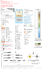
English: Template of Wikipedia map conventions. Français : Version anglais. Modèle pour la création de cartes géographiques et topographiques avec les principaux éléments habituellement employés et qui suit les conventions cartographiques actuelles de WP-fr et pour certains éléments en partie dans WP-de. (Pour le version Français, cliquez ici.) |
||||||||
| 日期 | 29 November 2014 (English translation); 14 October 2012 (French original work) | ||||||||
| 来源 |
|
||||||||
| 作者 | Eric Gaba (Sting - fr:Sting) | ||||||||
| 授权 (二次使用本文件) |
我,本作品著作权人,特此采用以下许可协议发表本作品:
您可以选择您需要的许可协议。 |
||||||||
| 其他版本 |
English: Versions of the Maps template, a toolbox helping wiki-mapmakers and contains icons and formatted text/objects that serve as a template for Wikipedia map conventions. The French version is the 'mother one', the first to be updated, and is frequently improved and updated following calm talks between mapmakers. Experienced cartographers may propose (using English) a new icon on this talkpage.
|


W3C-validity not checked.
原始上传日志[编辑]
This image is a derivative work of the following images:
- File:Maps_template-fr.svg licensed with Cc-by-2.5, Cc-by-2.5, GFDL, GFDL/en
- 2009-01-27T13:06:03Z Yug 1100x1500 (203738 Bytes) MINOR UPDATES: 2009/01/27. Add: port ; bat. judaisme, bat. chinese religions. Correct: terre principal fefee4 -> fefee9 (german usage) Add frames' titles, legend box. Move frames to more suitable place.
- 2008-09-04T00:08:14Z Sting 1100x1500 (176632 Bytes) Several little improvements
- 2008-07-15T14:45:27Z Sting 1100x1500 (170548 Bytes) Some improvements
- 2008-06-24T01:02:19Z Sting 1100x1500 (170673 Bytes) Valors for elevations and depths deleted to avoid confusion
- 2008-06-23T18:53:20Z Sémhur 1100x1500 (170836 Bytes) Change lighthouse icon, and decrease weight
- 2008-06-22T14:26:16Z Sting 1100x1500 (209351 Bytes) Additional topo colors for high elevations/permanent snow areas
- 2008-06-18T13:06:33Z Sting 1100x1500 (202960 Bytes) Additional modifications
- 2008-06-17T02:19:19Z Sting 1100x1500 (202606 Bytes) Some slight modifications
- 2008-06-13T14:51:52Z Sting 1100x1500 (202325 Bytes) Linear scales reduced to one type
- 2008-06-11T22:30:44Z Sting 1100x1500 (331785 Bytes) Some adjustments
- 2008-06-11T03:57:09Z Sting 1100x1500 (324893 Bytes) == Summary == {{Information |Description={{en|Template for the creation of geographic and topographic maps with the most common features used and following the convention to be used in the whole Wikimedia projet. *'''''Import
Uploaded with derivativeFX
文件历史
点击某个日期/时间查看对应时刻的文件。
| 日期/时间 | 缩略图 | 大小 | 用户 | 备注 | |
|---|---|---|---|---|---|
| 当前 | 2022年7月13日 (三) 05:31 | | 1,096 × 1,797(290 KB) | Chess(留言 | 贡献) | fix minor typo |
| 2014年12月4日 (四) 15:03 |  | 1,096 × 1,797(290 KB) | Goran tek-en(留言 | 贡献) | This file is now edited so that Id-names and Label-names for objects pass thru the validator (gets green ribbon) for xml [http://validator.w3.org/ w3 validator]. No errors but warnings for no fall back font. The font is also changed to Liberation sans... | |
| 2014年11月30日 (日) 02:51 |  | 1,100 × 1,600(251 KB) | AHeneen(留言 | 贡献) | Translation of the French version dated 14 October 2012 | |
| 2011年6月12日 (日) 06:31 |  | 1,100 × 1,500(197 KB) | Juergeen(留言 | 贡献) | typos | |
| 2011年6月12日 (日) 06:30 |  | 1,100 × 1,500(197 KB) | Juergeen(留言 | 贡献) | typos | |
| 2009年1月27日 (二) 17:53 |  | 1,100 × 1,500(197 KB) | Bamse(留言 | 贡献) | {{Information |Description={{en|Template for the creation of geographic and topographic maps with the most common features used, following the current convention in WP-fr, and for some elements also in part of WP-de.}} {{fr|Modèle pour la création de ca |
您不可以覆盖此文件。
文件用途
超过100个页面使用本文件。 下面的列表只显示使用本文件的前100个页面。完整列表可用。
- User:Yug
- User:Yug/Recommendations
- Commons talk:Project Mapmaking Wiki Standards
- Commons talk:Project Mapmaking Wiki Standards/Archive01
- File:Lage des Alb-Donau-Kreises in Deutschland.png
- File:Lage des Bodenseekreises in Deutschland.png
- File:Lage des Landkreises Biberach in Deutschland.png
- File:Lage des Landkreises Loerrach in Deutschland.png
- File:Locator map AC (city) in Germany.svg
- File:Locator map AC (district) in Germany.svg
- File:Locator map AC (region) in Germany.svg
- File:Locator map BGL in Bavaria.svg
- File:Locator map BI in Germany.svg
- File:Locator map BM in Germany.svg
- File:Locator map BN in Germany.svg
- File:Locator map BOR in Germany.svg
- File:Locator map BOT in Germany.svg
- File:Locator map BO in Germany.svg
- File:Locator map Baden-Württemberg in Germany.svg
- File:Locator map Bavaria in Germany.svg
- File:Locator map Berlin in Germany.svg
- File:Locator map Brandenburg in Germany.svg
- File:Locator map Bremen in Germany.svg
- File:Locator map COE in Germany.svg
- File:Locator map DN in Germany.svg
- File:Locator map DO in Germany.svg
- File:Locator map DU in Germany.svg
- File:Locator map D in Germany.svg
- File:Locator map EN in Germany.svg
- File:Locator map EU in Germany.svg
- File:Locator map E in Germany.svg
- File:Locator map GE in Germany.svg
- File:Locator map GL in Germany.svg
- File:Locator map GM in Germany.svg
- File:Locator map GT in Germany.svg
- File:Locator map HAM in Germany.svg
- File:Locator map HA in Germany.svg
- File:Locator map HER in Germany.svg
- File:Locator map HF in Germany.svg
- File:Locator map HSK in Germany.svg
- File:Locator map HS in Germany.svg
- File:Locator map HX in Germany.svg
- File:Locator map Hamburg in Germany.svg
- File:Locator map Hesse in Germany.svg
- File:Locator map KLE in Germany.svg
- File:Locator map KR in Germany.svg
- File:Locator map K in Germany.svg
- File:Locator map LEV in Germany.svg
- File:Locator map LIP in Germany.svg
- File:Locator map LVR in Germany.svg
- File:Locator map LWL in Germany.svg
- File:Locator map Lower-Saxony in Germany.svg
- File:Locator map ME in Germany.svg
- File:Locator map MG in Germany.svg
- File:Locator map MH in Germany.svg
- File:Locator map MI in Germany.svg
- File:Locator map MK in Germany.svg
- File:Locator map MS in Germany.svg
- File:Locator map Mecklenburg-Vorpommern in Germany.svg
- File:Locator map NE in Germany.svg
- File:Locator map North Rhine-Westphalia in Germany.svg
- File:Locator map OB in Germany.svg
- File:Locator map OE in Germany.svg
- File:Locator map PB in Germany.svg
- File:Locator map RB AR in Germany.svg
- File:Locator map RB DT in Germany.svg
- File:Locator map RB D in Germany.svg
- File:Locator map RB K in Germany.svg
- File:Locator map RB MS in Germany.svg
- File:Locator map RE in Germany.svg
- File:Locator map RS in Germany.svg
- File:Locator map RVR in Germany.svg
- File:Locator map Rhineland-Palatinate in Germany.svg
- File:Locator map SG in Germany.svg
- File:Locator map SI in Germany.svg
- File:Locator map SLS in Saarland.svg
- File:Locator map SO in Germany.svg
- File:Locator map ST in Germany.svg
- File:Locator map SU in Germany.svg
- File:Locator map Saarland in Germany.svg
- File:Locator map Saxony-Anhalt in Germany.svg
- File:Locator map Saxony in Germany.svg
- File:Locator map Schleswig-Holstein in Germany.svg
- File:Locator map Thuringia in Germany.svg
- File:Locator map UN in Germany.svg
- File:Locator map VIE in Germany.svg
- File:Locator map WAF in Germany.svg
- File:Locator map WES in Germany.svg
- File:Locator map WIL in Rhineland-Palatinate.svg
- File:Locator map W in Germany.svg
- File:Madagascar range map template.svg
- File:Maps template-en.svg
- File:Maps template-fr.svg
- File:Municipio 1 in Milan.svg
- File:Municipio 2 in Milan.svg
- File:Municipio 3 in Milan.svg
- File:Municipio 4 in Milan.svg
- File:Municipio 5 in Milan.svg
- File:Municipio 6 in Milan.svg
- File:Municipio 7 in Milan.svg
_in_Germany.svg)
_in_Germany.svg)
_in_Germany.svg)
查看连接到这个文件的更多链接。
全域文件用途
以下其他wiki使用此文件:
- en.wikipedia.org上的用途
- Wikipedia:WikiProject Maps
- Wikipedia talk:Manual of Style/Diagrams and maps
- User:Yug
- Wikipedia:WikiProject Maps/Conventions
- Wikipedia:WikiProject Maps/Conventions/Exchanges maps
- Wikipedia:WikiProject Maps/Conventions/Area maps
- Wikipedia:WikiProject Maps/Conventions/Topographic maps
- Wikipedia:WikiProject Maps/Conventions/Location maps
- Wikipedia:WikiProject Maps/Conventions/Locator maps
- Template:Map conventions
- User:Yug/Map convention
- Wikipedia:WikiProject Maps/Conventions/Historical maps
- User:Wereldburger758
- User:DiverDave/Useful
- Wikipedia:WikiProject Maps/Conventions/Orthographic maps
- User:Jm34harvey/Mapping
- Wikipedia talk:WikiProject Maps/Archive 2009
- Wikipedia talk:WikiProject Maps/Archive 2010
- Wikipedia:Village pump (miscellaneous)/Archive 32
- User:Jkan997
- Wikipedia:Graphics Lab/Resources/GIS sources and palettes
- Wikipedia:Reference desk/Archives/Miscellaneous/2011 July 1
- Wikipedia:WikiProject Maps/Conventions/Disputed areas
- Wikipedia:WikiProject Maps/Conventions/Gradient maps
- Wikipedia:WikiProject Maps/Conventions/Pushpin maps
- Wikipedia:WikiProject Maps/Conventions/US locations
- User:Every-leaf-that-trembles
- Wikipedia talk:WikiProject Maps/Archive 2017
- User:Beevil/Useful
- Typography (cartography)
- Wikipedia:WikiProject Maps/Conventions/Location maps (series N)
- ja.wikipedia.org上的用途
- pl.wikipedia.org上的用途
- sl.wikipedia.org上的用途
- tg.wikipedia.org上的用途
- www.wikidata.org上的用途
- zh.wikipedia.org上的用途