File:Melia azedarach (429546268).jpg

Original file (2,816 × 2,112 pixels, file size: 2.45 MB, MIME type: image/jpeg)
Captions
Captions
Summary
[edit].jpg&action=edit§ion=1)
| Description |
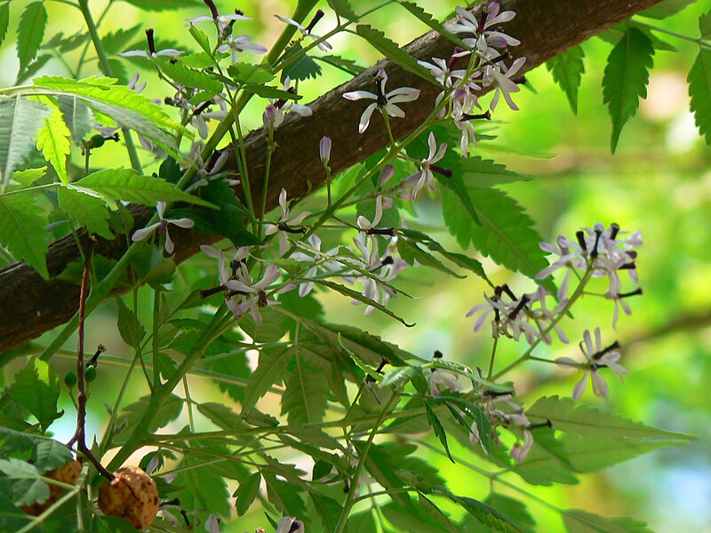
Common name: Chinaberry tree, Persian lilac, Pride of India, Bead tree, Lilac tree, Bakain बकैन (Hindi), Seizrak (Manipuri), Bakan-nimb बकाणनिंब (Marathi), Bakarjam (Bengali), Kattu vembhu காட்டு வேம்பூ (Tamil) Botanical name: Melia azedarach (ME-lee-uh) from the Greek name for Ash; (az-ee-duh-rak) from the Persian words meaning noble tree Synonyms: Melia australis, Melia japonica, Melia sempervivens, Melia azedarach var. umbraculifera Family: Meliaceae (melia, or mahogany family) - [ (me-lee-AY-see-ay) the Melia family (from the Greek name for Ash) due to the similarity of the leaves ] Origin: India The lovely Bead Tree is somewhat similar to the Nim in appearance and takes the place of that tree in the Northern parts of India. Both have compound leaves with narrow, serrate-edged leaflets terminating in long points but those of the Bead Tree are smaller, lack the sythe-like curve and are subdivided at the base into several pinnae bearing five or seven leaflets. The Bead Tree is indigenous to parts of N. India and Burma and is now cultivated in all the sub-tropical regions of the world. Melia is the Greek name of the Ash, but is not very appropriate as there is only superficial resemblance between the Bead tree and the Ash. Azedarach is from the Persian azad-darakht. It is a medium-sized tree, fast-growing and attaining up to 40 feet in height in a few years, but its beauty is short-lived; at the age of about 20 years it commences to die off. The bark is dark grey-brown cracked vertically by long furrows. Courtesy: - Flowers of India - TopTropicals - Dave's Garden - Zipcode Zoo Note: Information has not been verified and may not be reliable; please check for any inaccuracy. |
| Date | |
| Source | Melia azedarach |
| Author | Dinesh Valke from Thane, India |
| Camera location | | View this and other nearby images on: OpenStreetMap |
|---|
.jpg¶ms=019.119553_N_0072.874717_E_globe:Earth_type:camera_source:Flickr_&language=en)
Licensing
[edit].jpg&action=edit§ion=2)
- You are free:
- to share – to copy, distribute and transmit the work
- to remix – to adapt the work
- Under the following conditions:
- attribution – You must give appropriate credit, provide a link to the license, and indicate if changes were made. You may do so in any reasonable manner, but not in any way that suggests the licensor endorses you or your use.
- share alike – If you remix, transform, or build upon the material, you must distribute your contributions under the same or compatible license as the original.
| This image was originally posted to Flickr by dinesh_valke at https://flickr.com/photos/91314344@N00/429546268. It was reviewed on 21 September 2016 by FlickreviewR and was confirmed to be licensed under the terms of the cc-by-sa-2.0. |
File history
Click on a date/time to view the file as it appeared at that time.
| Date/Time | Thumbnail | Dimensions | User | Comment | |
|---|---|---|---|---|---|
| current | 06:41, 21 September 2016 | | 2,816 × 2,112 (2.45 MB) | Sreejithk2000 (talk | contribs) | Transferred from Flickr via Flickr2Commons |
You cannot overwrite this file.
File usage on Commons
There are no pages that use this file.
File usage on other wikis
The following other wikis use this file:
- Usage on vi.wikipedia.org
.jpg&oldid=883691372)