File:Michoud Station and vicinity map 1883.png
Jump to navigation
Jump to search
Size of this preview: 800 × 147 pixels. Other resolutions: 320 × 59 pixels | 640 × 117 pixels | 1,024 × 188 pixels | 4,431 × 813 pixels.
Original file (4,431 × 813 pixels, file size: 1.59 MB, MIME type: image/png)
Captions
Captions
Add a one-line explanation of what this file represents
Summary[edit]
| Description |
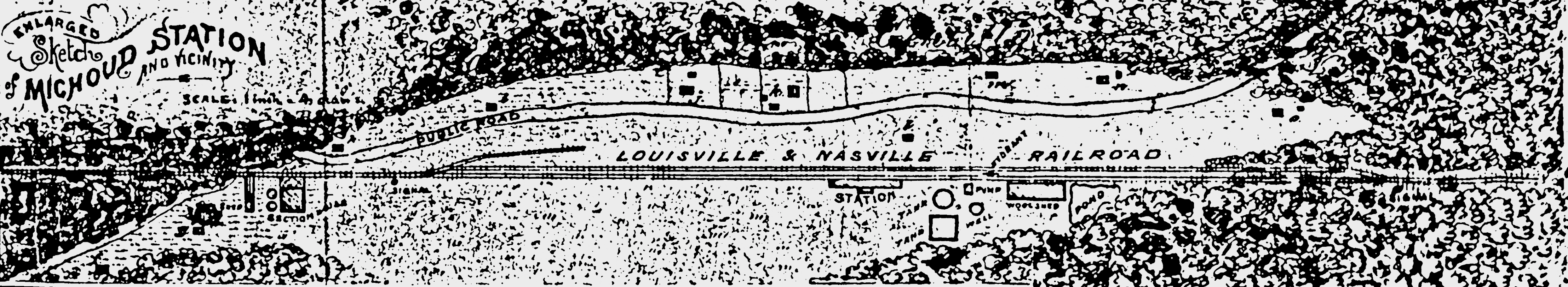
English: 1883 map |
| Date | |
| Source | cropped from scanned antique map, uploaded at File:Alphonse michoud map.tif |
| Author | Geo. H. Grandjean (1846-1900) civil engineer |
| Other versions |
|
Licensing[edit]
This work is in the public domain in the United States because it was published (or registered with the U.S. Copyright Office) before January 1, 1929.
|
|
This work is in the public domain in its country of origin and other countries and areas where the copyright term is the author's life plus 100 years or fewer.
| |
| This file has been identified as being free of known restrictions under copyright law, including all related and neighboring rights. | |
File history
Click on a date/time to view the file as it appeared at that time.
| Date/Time | Thumbnail | Dimensions | User | Comment | |
|---|---|---|---|---|---|
| current | 01:54, 6 August 2022 | 4,431 × 813 (1.59 MB) | Infrogmation (talk | contribs) | {{Information |description={{en|1=1883 map }} |date=1883-08-03 |source= cropped from scanned antique map, uploaded at File:Alphonse michoud map.tif |author= Geo. H. Grandjean (1846-1900) civil engineer |permission= |other versions= * Full original map tif: File:Alphonse michoud map.tif * Full map, border cropped, converted from tif to png: File:Alphonse michoud map.png }} =={{int:license-header}}== {{PD-US-expired|PD-Old-100}} Category:1883 maps of New Orleans [[Categ... |
You cannot overwrite this file.
File usage on Commons
There are no pages that use this file.