File:Mid-ocean ridge topography.gif
Naviqasiyaya keç
Axtarışa keç
Daha yüksək versiyası yoxdur.
Mid-ocean_ridge_topography.gif (240 × 180 piksel, fayl həcmi: 1,06 MB, MIME növü: image/gif, ilmələnib, 70 çərçivə, 14 s)
Captions
Captions
Add a one-line explanation of what this file represents
Xülasə[redaktə]
| İzah |
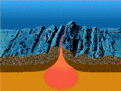
English: A close-up showing mid-ocean ridge topography with magma chamber below, which rises and new ocean plates spreads away from ridge. |
| Tarix | |
| Mənbə | http://geomaps.wr.usgs.gov/parks/animate/index.html |
| Müəllif | USGS |
Lisenziya[redaktə]
This image is in the public domain in the United States because it only contains materials that originally came from the United States Geological Survey, an agency of the United States Department of the Interior. For more information, see the official USGS copyright policy.
|
Faylın tarixçəsi
Faylın əvvəlki versiyasını görmək üçün gün/tarix bölməsindəki tarixlərə klikləyin.
| Tarix/Vaxt | Kiçik şəkil | Ölçülər | İstifadəçi | Şərh | |
|---|---|---|---|---|---|
| indiki | 15:04, 19 fevral 2011 | | 240 × 180 (1,06 MB) | דקי (müzakirə | töhfələr) | {{Information |Description ={{en|1=A close-up showing mid-ocean ridge topography with magma chamber below, which rises and new ocean plates spreads away from ridge.}} |Source =http://geomaps.wr.usgs.gov/parks/animate/index.html |Author |
Siz bu faylı yenidən yükləyə bilməzsiniz.
Fayl keçidləri
Aşağıdakı səhifə bu faylı istifadə edir:
Faylın qlobal istifadəsi
Bu fayl aşağıdakı vikilərdə istifadə olunur:
- an.wikipedia.org layihəsində istifadəsi
- ar.wikipedia.org layihəsində istifadəsi
- ast.wikipedia.org layihəsində istifadəsi
- az.wikipedia.org layihəsində istifadəsi
- bg.wikipedia.org layihəsində istifadəsi
- ca.wikipedia.org layihəsində istifadəsi
- de.wikipedia.org layihəsində istifadəsi
- de.wiktionary.org layihəsində istifadəsi
- en.wikipedia.org layihəsində istifadəsi
- en.wikiquote.org layihəsində istifadəsi
- es.wikipedia.org layihəsində istifadəsi
- eu.wikipedia.org layihəsində istifadəsi
- fi.wikipedia.org layihəsində istifadəsi
- fr.wikipedia.org layihəsində istifadəsi
- gl.wikipedia.org layihəsində istifadəsi
- he.wikipedia.org layihəsində istifadəsi
- hi.wikipedia.org layihəsində istifadəsi
- hu.wikipedia.org layihəsində istifadəsi
- it.wikipedia.org layihəsində istifadəsi
- it.wikibooks.org layihəsində istifadəsi
- it.wikiversity.org layihəsində istifadəsi
- ja.wikipedia.org layihəsində istifadəsi
- ja.wikibooks.org layihəsində istifadəsi
- ko.wikipedia.org layihəsində istifadəsi
- kw.wikipedia.org layihəsində istifadəsi
- lv.wikipedia.org layihəsində istifadəsi
- mk.wikipedia.org layihəsində istifadəsi
Bu faylın qlobal istifadəsinə baxın.