File:Mid-ocean ridge topography.gif
跳去導覽
跳去搵嘢
冇更高解像度嘅圖像。
Mid-ocean_ridge_topography.gif (240 × 180 像素,檔案大細:1.06 MB ,MIME類型:image/gif、循環、70格、14 s)
Captions
Captions
Add a one-line explanation of what this file represents
摘要[編輯]
| 描述 |
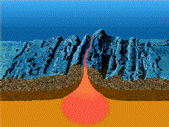
English: A close-up showing mid-ocean ridge topography with magma chamber below, which rises and new ocean plates spreads away from ridge. |
| 日期 | |
| 來源 | http://geomaps.wr.usgs.gov/parks/animate/index.html |
| 作者 | USGS |
協議[編輯]
This image is in the public domain in the United States because it only contains materials that originally came from the United States Geological Survey, an agency of the United States Department of the Interior. For more information, see the official USGS copyright policy.
|
檔案歷史
撳個日期/時間去睇響嗰個時間出現過嘅檔案。
| 日期/時間 | 縮圖 | 尺寸 | 用戶 | 註解 | |
|---|---|---|---|---|---|
| 現時 | 2011年2月19號 (六) 15:04 | | 240 × 180(1.06 MB) | דקי(傾偈 | 貢獻) | {{Information |Description ={{en|1=A close-up showing mid-ocean ridge topography with magma chamber below, which rises and new ocean plates spreads away from ridge.}} |Source =http://geomaps.wr.usgs.gov/parks/animate/index.html |Author |
你無得衾咗個檔案。
檔案用途
以下嘅1版用到呢個檔:
全域檔案使用情況
下面嘅維基都用緊呢個檔案:
- an.wikipedia.org嘅使用情況
- ar.wikipedia.org嘅使用情況
- ast.wikipedia.org嘅使用情況
- az.wikipedia.org嘅使用情況
- bg.wikipedia.org嘅使用情況
- ca.wikipedia.org嘅使用情況
- de.wikipedia.org嘅使用情況
- de.wiktionary.org嘅使用情況
- en.wikipedia.org嘅使用情況
- en.wikiquote.org嘅使用情況
- es.wikipedia.org嘅使用情況
- eu.wikipedia.org嘅使用情況
- fi.wikipedia.org嘅使用情況
- fr.wikipedia.org嘅使用情況
- gl.wikipedia.org嘅使用情況
- he.wikipedia.org嘅使用情況
- hi.wikipedia.org嘅使用情況
- hu.wikipedia.org嘅使用情況
- it.wikipedia.org嘅使用情況
- it.wikibooks.org嘅使用情況
- it.wikiversity.org嘅使用情況
- ja.wikipedia.org嘅使用情況
- ja.wikibooks.org嘅使用情況
- ko.wikipedia.org嘅使用情況
- kw.wikipedia.org嘅使用情況
- lv.wikipedia.org嘅使用情況
- mk.wikipedia.org嘅使用情況
睇呢個檔案嘅更多全域使用情況。