File:Mining Map of Northern Transylvania in Danubius Pannonico-Mysicus 1726 by Marsigli, v2.jpg
Aller à la navigation
Aller à la recherche

Taille de cet aperçu : 485 × 600 pixels. Autres résolutions : 194 × 240 pixels | 388 × 480 pixels | 621 × 768 pixels | 1 276 × 1 578 pixels.
Fichier d’origine (1 276 × 1 578 pixels, taille du fichier : 436 kio, type MIME : image/jpeg)
Légendes
Légendes
Ajoutez en une ligne la description de ce que représente ce fichier
Description
[modifier]| Mappa Mineralographica | |
|---|---|
| Artiste | |
| Titre |
Mappa Mineralographica |
| Description |
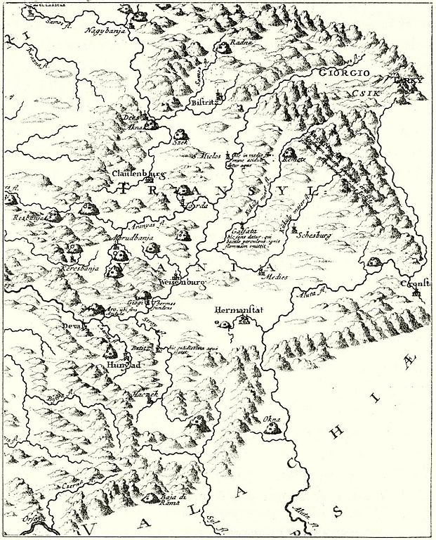
English: Mining map of Northern Transylvania (Romania). Published in the 1726 work Danubius Pannonico-Mysicus, vol. 2 by the Italian naturalist and soldier Luigi Ferdinando Marsigli (1658 – 1730).
Ce fichier a été téléversé avec Commonist. |
| Date | 1726 |
| Source / photographe | [1] at mek.niif.hu |
| Autres versions |
|

| Luigi Ferdinando Marsigli : Danubius Pannonico-Mysicus | |||||||||||||||||||||||||||||||||||||||||||||||||||||
|---|---|---|---|---|---|---|---|---|---|---|---|---|---|---|---|---|---|---|---|---|---|---|---|---|---|---|---|---|---|---|---|---|---|---|---|---|---|---|---|---|---|---|---|---|---|---|---|---|---|---|---|---|---|
| Auteur |
|
 | |||||||||||||||||||||||||||||||||||||||||||||||||||
| Illustrateur |
|
||||||||||||||||||||||||||||||||||||||||||||||||||||
| Titre | |||||||||||||||||||||||||||||||||||||||||||||||||||||
| Sous-titre | Observationibus geographicis, astronomicis, hydrographicis, historicis, physicis perlustratus | ||||||||||||||||||||||||||||||||||||||||||||||||||||
| Volume | 1–6 | ||||||||||||||||||||||||||||||||||||||||||||||||||||
| Éditeur de publication | |||||||||||||||||||||||||||||||||||||||||||||||||||||
| Description |
English: 1726 work by the Italian naturalist and soldier Luigi Ferdinando Marsigli (1658 – 1730). It is a natural history encyclopedia of the lower Danube, published in 6 volumes in both The Hague and Amsterdam. The extensive work covers cartography (vol. 1), classical studies (vol. 2), mineralogy (vol. 3), fish fauna (vol. 4), birds (vol. 5) and other subjects (vol. 6).
Detailed information by volumes:
|
||||||||||||||||||||||||||||||||||||||||||||||||||||
| Langue | latin | ||||||||||||||||||||||||||||||||||||||||||||||||||||
| Date de publication | 1726 | ||||||||||||||||||||||||||||||||||||||||||||||||||||
| Lieu de publication | The Hague and Amsterdam | ||||||||||||||||||||||||||||||||||||||||||||||||||||
| Source | Various, see individual images/pages | ||||||||||||||||||||||||||||||||||||||||||||||||||||
| Autorisation (Réutilisation de ce fichier) |
|
||||||||||||||||||||||||||||||||||||||||||||||||||||


Conditions d’utilisation
[modifier]
|
Cette œuvre est également dans le domaine public dans tous les pays pour lesquels le droit d’auteur a une durée de vie de 100 ans ou moins après la mort de l’auteur. | |
| Ce fichier a été identifié comme étant exempt de restrictions connues liées au droit d’auteur, y compris tous les droits connexes et voisins. | |
Historique du fichier
Cliquer sur une date et heure pour voir le fichier tel qu'il était à ce moment-là.
| Date et heure | Vignette | Dimensions | Utilisateur | Commentaire | |
|---|---|---|---|---|---|
| actuel | 17 décembre 2011 à 23:53 | | 1 276 × 1 578 (436 kio) | Codrinb (d | contributions) |
Vous ne pouvez pas remplacer ce fichier.
Utilisations locales du fichier
Les 3 pages suivantes utilisent ce fichier :
Utilisations du fichier sur d’autres wikis
Les autres wikis suivants utilisent ce fichier :
- Utilisation sur fr.wikipedia.org