File:MSH80 mudline muddy river with USGS scientist 10-23-80.jpg
(Redirected from File:Mudline from 1980 St Helens lahars next to Muddy River.jpg)

Size of this preview: 800 × 536 pixels. Other resolutions: 320 × 215 pixels | 640 × 429 pixels | 1,024 × 687 pixels | 1,280 × 858 pixels | 2,904 × 1,947 pixels.
Original file (2,904 × 1,947 pixels, file size: 2.64 MB, MIME type: image/jpeg)
Captions
Captions
Add a one-line explanation of what this file represents
Summary[edit]
| Description |
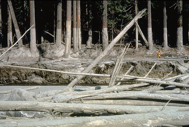
English: (copied description from USGS site): Nearly 135 miles (220 kilometers) of river channels surrounding the volcano [Mt. St. Helens] were affected by the lahars of May 18, 1980. A mudline left behind on trees shows depths reached by the mud. A scientist (middle right) gives scale. This view is along the Muddy River, southeast of Mount St. Helens. |
| Date | Taken on 23 October 1980 |
| Source | http://vulcan.wr.usgs.gov/Glossary/Lahars/description_lahars.html |
| Author | Lyn Topinka, USGS |
Licensing[edit]
This image is in the public domain in the United States because it only contains materials that originally came from the United States Geological Survey, an agency of the United States Department of the Interior. For more information, see the official USGS copyright policy.
|
File history
Click on a date/time to view the file as it appeared at that time.
| Date/Time | Thumbnail | Dimensions | User | Comment | |
|---|---|---|---|---|---|
| current | 03:35, 12 December 2022 | | 2,904 × 1,947 (2.64 MB) | Hike395 (talk | contribs) | less jpeg compression, re-crop from original |
| 02:32, 10 October 2011 |  | 2,916 × 1,948 (1.21 MB) | Materialscientist (talk | contribs) | crop frame | |
| 15:02, 2 September 2010 |  | 3,072 × 2,048 (4.07 MB) | Awickert (talk | contribs) | {{Information |Description={{en|1=(copied description from USGS site): Nearly 135 miles (220 kilometers) of river channels surrounding the volcano [Mt. St. Helens] were affected by the lahars of May 18, 1980. A mudline left behind on trees shows depths re |
You cannot overwrite this file.
File usage on Commons
The following page uses this file:
- File:Mudline from 1980 St Helens lahars next to Muddy River.jpg (file redirect)
File usage on other wikis
The following other wikis use this file:
- Usage on bg.wikipedia.org
- Usage on bn.wikipedia.org
- Usage on cs.wikipedia.org
- Usage on de.wikipedia.org
- Usage on en.wikipedia.org
- Usage on es.wikipedia.org
- Usage on fr.wikipedia.org
- Usage on he.wikipedia.org
- Usage on id.wikipedia.org
- Usage on it.wikipedia.org
- Usage on nl.wikipedia.org
- Usage on oc.wikipedia.org
- Usage on ro.wikipedia.org
- Usage on sk.wikipedia.org
- Usage on sv.wikipedia.org
- Usage on tr.wikipedia.org
- Usage on uk.wikipedia.org
- Usage on vi.wikipedia.org
- Usage on www.wikidata.org
- Usage on zh.wikipedia.org