File:NASA RabaulVolcano PIA01767.jpg
跳转到导航
跳转到搜索

本预览的尺寸:515 × 600像素。 其他分辨率:206 × 240像素 | 412 × 480像素 | 853 × 993像素。
原始文件 (853 × 993像素,文件大小:855 KB,MIME类型:image/jpeg)
说明
说明
添加一行文字以描述该文件所表现的内容
摘要
[编辑]| 描述 |
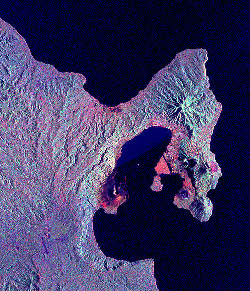
English: Space Radar Image of Rabaul Volcano, New Guinea
Credit NASA JPL http://visibleearth.nasa.gov/view_rec.php?id=434 This is a radar image of the Rabaul volcano on the island of New Britain, Papua New Guinea taken almost a month after its September 19, 1994, eruption that killed five people and covered the town of Rabaul and nearby villages with up to 75 centimeters (30 inches) of ash. More than 53,000 people have been displaced by the eruption. The image was acquired by the Spaceborne Imaging Radar-C/X-band Synthetic Aperture Radar (SIR-C/X-SAR) aboard the space shuttle Endeavour on its 173rd orbit on October 11, 1994. This image is centered at 4.2 degrees south latitude and 152.2 degrees east longitude in the southwest Pacific Ocean. The area shown is approximately 21 kilometers by 25 kilometers (13 miles by 15.5 miles). North is toward the upper right. The colors in this image were obtained using the following radar channels: red represents the L-band (horizontally transmitted and received); green represents the L-band (horizontally transmitted and vertically received); blue represents the C-band (horizontally transmitted and vertically received). |
|||||
| 来源 | http://visibleearth.nasa.gov/view_rec.php?id=434 | |||||
| 作者 | NASA/JPL | |||||
| 授权 (二次使用本文件) |
|

| 此标签不表示文件的著作权状态。任何文件在附有此标签的同時还需要一个有效的著作权标签。请参阅许可协议说明页面以了解更多信息。 其他语言:
|
原始上传日志
[编辑]
原始描述頁面位於這裡。下列使用者名稱均來自en.wikipedia。
- 2005-05-17 12:15 SeanMack 853×993× (875239 bytes) {{PD-USGov-NASA}} Space Radar Image of Rabaul Volcano, New Guinea Credit NASA JPL http://visibleearth.nasa.gov/view_rec.php?id=434 This is a radar image of the Rabaul volcano on the island of New Britain, Papua New Guinea taken almost a month after
文件历史
点击某个日期/时间查看对应时刻的文件。
| 日期/时间 | 缩略图 | 大小 | 用户 | 备注 | |
|---|---|---|---|---|---|
| 当前 | 2009年5月1日 (五) 13:17 | | 853 × 993(855 KB) | File Upload Bot (Magnus Manske)(留言 | 贡献) | {{BotMoveToCommons|en.wikipedia|year={{subst:CURRENTYEAR}}|month={{subst:CURRENTMONTHNAME}}|day={{subst:CURRENTDAY}}}} {{Information |Description={{en|Space Radar Image of Rabaul Volcano, New Guinea Credit NASA JPL http://visibleearth.nasa.gov/view_re |
您不可以覆盖此文件。
文件用途
没有页面使用本文件。
全域文件用途
以下其他wiki使用此文件:
- br.wikipedia.org上的用途
- en.wikipedia.org上的用途
- fa.wikipedia.org上的用途
- fr.wikipedia.org上的用途
- hu.wikipedia.org上的用途
- id.wikipedia.org上的用途
- it.wikipedia.org上的用途
- ja.wikipedia.org上的用途
- ko.wikipedia.org上的用途
- nl.wikipedia.org上的用途
- ru.wikipedia.org上的用途
- uk.wikipedia.org上的用途
- zh.wikipedia.org上的用途