File:ND Bachaue, Röhricht und Quellfluren süd-südwestlich von Herrnöd Amtsblatt.jpg
Jump to navigation
Jump to search

Size of this preview: 429 × 599 pixels. Other resolutions: 172 × 240 pixels | 344 × 480 pixels | 809 × 1,129 pixels.
Original file (809 × 1,129 pixels, file size: 410 KB, MIME type: image/jpeg)
Captions
Captions
Add a one-line explanation of what this file represents
Summary
[edit]
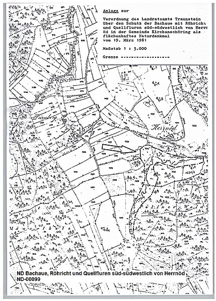
| Description | ND Bachaue, Röhricht und Quellfluren süd-südwestlich von Herrnöd, Lageplan der Verordnung, ND-00099 |
| Date | |
| Source | Amtsblatt Lkr. Traunstein, 3. April 1981 |
| Author | Landratsamt Traunstein |
| Permission (Reusing this file) |
gemeinfrei |
| Camera location | | View this and other nearby images on: OpenStreetMap |
|---|
| This image is in the public domain according to German copyright law because it is part of a statute, ordinance, official decree or judgment (official work) issued by a German authority or court (§ 5 Abs.1 UrhG).
|
 |
File history
Click on a date/time to view the file as it appeared at that time.
| Date/Time | Thumbnail | Dimensions | User | Comment | |
|---|---|---|---|---|---|
| current | 16:11, 22 February 2024 | | 809 × 1,129 (410 KB) | Perchtinger (talk | contribs) | == {{int:filedesc}} == {{Information |Description=ND Bachaue, Röhricht und Quellfluren süd-südwestlich von Herrnöd, Lageplan der Verordnung, ND-00099 |Source=Amtsblatt Lkr. Traunstein, 3. April 1981 |Date=1981-03-19 |Author= Landratsamt Traunstein |Permission=gemeinfrei |other_versions= }} {{Location|47.95292|12.81941|region:DE-BY}} {{PD-GermanGov}} Category:Herrnöd Category:Natural monuments in Landkreis Traunstein |
You cannot overwrite this file.
File usage on Commons
The following page uses this file:
File usage on other wikis
The following other wikis use this file:
- Usage on de.wikipedia.org