File:Nationalities in Second Polish Republic ca. 1931.png
跳至導覽
跳至搜尋
預覽大小:445 × 600 像素。 其他解析度:178 × 240 像素 | 356 × 480 像素 | 668 × 900 像素。
原始檔案 (668 × 900 像素,檔案大小:193 KB,MIME 類型:image/png)
說明
說明
添加單行說明來描述出檔案所代表的內容
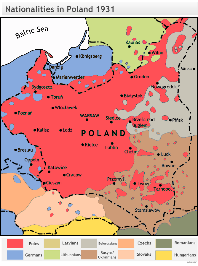
| 描述 | Dominating nationalities in Poland and around, 1931 (for the Polish census of 1931 see this map File:GUS languages1931 Poland.jpg). |
| 來源 |
1. Image:HistPol-narodowosci1931.png, 2. Eugenjusz Romer, POWSZECHNY ATLAS GEOGRAFICZNY, Książnica-Atlas, Lwów-Warszawa 1928 (mapa 48 ludność), 3. Henryk Zieliński Historia Polski 1914-1939, Wydawnictwo Ossolineum 1983, 4. ATLAS HISTORYCZNY POLSKI, PPWK Warszawa-Wrocław 1998 (mapa na str. 46 narodowości). |
| 作者 | Based on work by Henryk Zieliński, colored and translated in June 2007 by Krzysztoflew |
| 授權許可 (重用此檔案) |
GFDL and cc-by-sa-2.5 - derivative from original work |
| 其他版本 |
Derivative works of this file: NacionalidadesEnPolonia1931.svg Image:HistPol-narodowosci1931.png (black and white original) |
Compare with the map of ca. 1910 and Image:Narody2RP.png
Krzysztoflew,此作品的版權所有人,決定用以下授權條款發佈本作品:

|
已授權您依據自由軟體基金會發行的無固定段落、封面文字和封底文字GNU自由文件授權條款1.2版或任意後續版本,對本檔進行複製、傳播和/或修改。該協議的副本列在GNU自由文件授權條款中。 |
| 此檔案採用創用CC 姓名標示-相同方式分享 3.0 未在地化版本授權條款。 | ||
| 姓名標示: Krzysztoflew | ||
| ||
| 已新增授權條款標題至此檔案,作為GFDL授權更新的一部份。 |
您可以選擇您需要的授權條款。
檔案歷史
點選日期/時間以檢視該時間的檔案版本。
| 日期/時間 | 縮圖 | 尺寸 | 使用者 | 備註 | |
|---|---|---|---|---|---|
| 目前 | 2023年2月17日 (五) 16:18 | | 668 × 900(193 KB) | Moodylo333(留言 | 貢獻) | Removed colour blind, details according with the sources cited. |
| 2011年4月12日 (二) 15:04 |  | 668 × 900(233 KB) | Fentener van Vlissingen(留言 | 貢獻) | Reverted to version as of 14:28, 18 September 2009; it is not "my own map", I simply reverted to an earlier version. Your version does not reflect the source and is therefore wrong | |
| 2010年8月30日 (一) 11:45 |  | 668 × 900(295 KB) | Poeticbent(留言 | 貢獻) | Reverted to version as of 22:07, 12 January 2009 Please, do not reintroduce mistakes. Current map includes various levels of ethnic mixture. Your own map doesn't, which is wrong. | |
| 2009年9月18日 (五) 14:28 |  | 668 × 900(233 KB) | Fentener van Vlissingen(留言 | 貢獻) | Reverted to version as of 18:53, 10 July 2007; the additional colours do not make sense as they are not explained in the legend (why would Silesia be blue-pinkish?). Update was also not motivated. | |
| 2009年1月12日 (一) 22:07 |  | 668 × 900(295 KB) | Poeticbent(留言 | 貢獻) | {{Information |Description= |Source= |Date= |Author= |Permission= |other_versions= }} | |
| 2007年7月10日 (二) 18:53 |  | 668 × 900(233 KB) | Piotrus(留言 | 貢獻) | {{Information |Description=Dominating nationalities in Poland and around, 1931. |Source= This file is a translated and colored illustration from "Historia Polski 1914-1939" by en:Henryk Zieliński (a Polish historian) published by Wydawnictwo Ossolin |
無法覆蓋此檔案。
檔案用途
下列4個頁面有用到此檔案:
全域檔案使用狀況
以下其他 wiki 使用了這個檔案:
- ar.wikipedia.org 的使用狀況
- be.wikipedia.org 的使用狀況
- cs.wikipedia.org 的使用狀況
- da.wikipedia.org 的使用狀況
- de.wikipedia.org 的使用狀況
- en.wikipedia.org 的使用狀況
- Talk:Territories of Poland annexed by the Soviet Union
- Talk:Curzon Line
- Talk:History of Szczecin
- User talk:Scooter20
- Soviet annexation of Eastern Galicia and Volhynia
- Oder–Neisse line
- Talk:Soviet invasion of Poland/Archive 2
- User:Falcaorib/Ukraine
- User:Falcaorib/Poland-Lithuania
- User:Falcaorib/Belarus
- eo.wikipedia.org 的使用狀況
- et.wikipedia.org 的使用狀況
- fa.wikipedia.org 的使用狀況
- fi.wikipedia.org 的使用狀況
- fr.wikipedia.org 的使用狀況
- hi.wikipedia.org 的使用狀況
- hy.wikipedia.org 的使用狀況
- ka.wikipedia.org 的使用狀況
- ko.wikipedia.org 的使用狀況
- lv.wikipedia.org 的使用狀況
- no.wikipedia.org 的使用狀況
- pl.wikipedia.org 的使用狀況
- ru.wikipedia.org 的使用狀況
- sc.wikipedia.org 的使用狀況
- uk.wikipedia.org 的使用狀況
- www.wikidata.org 的使用狀況
- zh.wikipedia.org 的使用狀況