File:New York State, Double Page Plate No. 4 (Map of the state of New York showing the mean annual rail fall, Map showing in six degrees of density, The distribution of the Papulation of the state NYPL2056501.tiff
Jump to navigation
Jump to search

Size of this JPG preview of this TIF file: 800 × 600 pixels. Other resolutions: 320 × 240 pixels | 640 × 480 pixels | 1,024 × 768 pixels | 1,280 × 960 pixels | 2,560 × 1,920 pixels | 7,216 × 5,412 pixels.

Original file (7,216 × 5,412 pixels, file size: 112 MB, MIME type: image/tiff, 2 pages)
Captions
Captions
Add a one-line explanation of what this file represents
Summary[edit]
| Description | New York State, Double Page Plate No. 4 [Map of the state of New York showing the mean annual rail fall, Map showing in six degrees of density, The distribution of the Papulation of the state of New York, 1890, Hypsometric sketch of the State of New York, Map of the State of New York showing the mean annual Temperature]; Atlases of the United States / New York / Atlas of the State of New York / prepared under the direction of Joseph R. Bien...from original surveys and various local surveys revised and corrected... | |||||||||||||||||||||||
| Catalogue call number | Map Div.+++ (New York State) (Bien, J. R. Atlas) | |||||||||||||||||||||||
| Item/Page/Plate | 4 | |||||||||||||||||||||||
| Date | ||||||||||||||||||||||||
| Source |
http://digitalgallery.nypl.org/nypldigital/dgkeysearchdetail.cfm?imageID=2056501
|
|||||||||||||||||||||||
| Author | Joseph R. -- Publisher Bien | |||||||||||||||||||||||
| Permission (Reusing this file) |
From The Lionel Pincus and Princess Firyal Map Division. http://maps.nypl.org
|
|||||||||||||||||||||||
| Source description | [9] p., 37 col. maps on 59 leaves of plates ; 64 cm. | |||||||||||||||||||||||
| Location | Stephen A. Schwarzman Building / The Lionel Pincus and Princess Firyal Map Division | |||||||||||||||||||||||
| Digital item published | 7-20-2011 | |||||||||||||||||||||||
| Digital ID | 2056501 | |||||||||||||||||||||||

The making of this file was supported by Wikimedia UK.
To see other files made with the support of Wikimedia UK, please see the category Supported by Wikimedia UK.
|
File history
Click on a date/time to view the file as it appeared at that time.
| Date/Time | Thumbnail | Dimensions | User | Comment | |
|---|---|---|---|---|---|
| current | 12:33, 2 May 2014 | 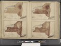 | 7,216 × 5,412, 2 pages (112 MB) | Fæ (talk | contribs) | GWToolset:: Creating mediafile for Fæ. Tranche 3 11591-16518 @ 2 May, 06:47 BST |
You cannot overwrite this file.
File usage on Commons
There are no pages that use this file.