File:New Zealand (5588544267).jpg
Original file (6,828 × 6,372 pixels, file size: 5.24 MB, MIME type: image/jpeg)
Captions
Captions
Summary
[edit].jpg&action=edit§ion=1)
| Description |
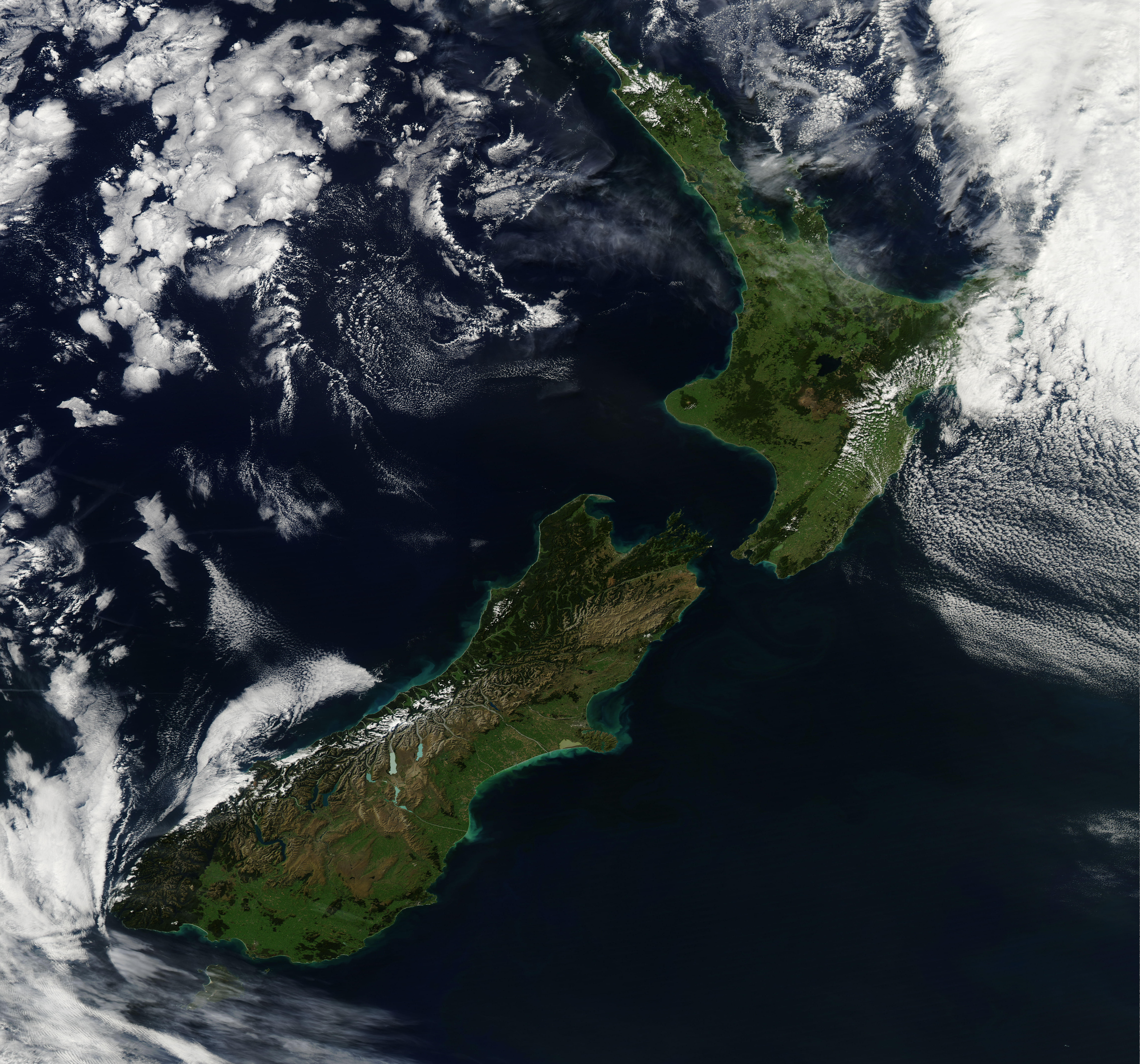
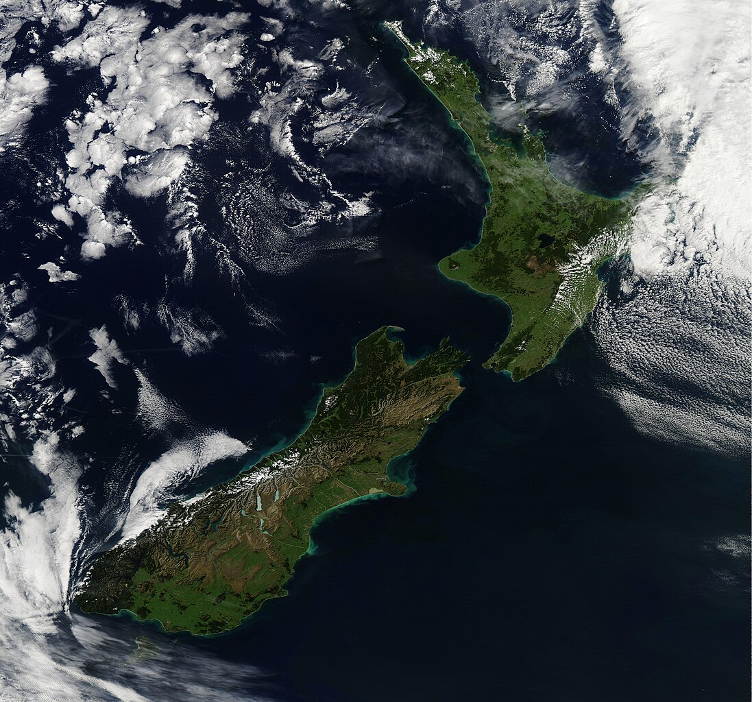
NASA image acquired March 30, 2011 On March 30, 2011, the Moderate Resolution Imaging Spectroradiometer (MODIS) aboard the Aqua satellite passed over New Zealand just as the clouds parted, and captured this striking view of the greens of very early fall. Near the top of the image, snow covers the highest peaks of the North Auckland (Northland) Peninsula. About half-way down the western shore of the peninsula lies Kaipara Harbor, a large estuary/harbor complex that opens to the Tasman Sea, and offers a diverse array of ecotones and habitats which provide food and housing for many species, especially migratory birds. Of the two main islands of New Zealand, North Island is the most volcanically active, with a large volcanic plateau running roughly southwest to northeast through North Island’s mainland. The large blue ring of Lake Taupo can be seen near the center of this plateau. The lake is actually nestled in the caldera of one of the world’s most active supervolcanoes. North Island is separated from South Island by Cook Strait, which is 14 miles (22 km) wide at the narrowest point. South Island is noted for the Southern Alps, which form a snow-and-glacier-covered spine near the western coast. Bright blue glacial lakes lie on the eastern side of the mountains, holding cold meltwater as it flows from the mountains to the South Pacific Ocean via the many rivers of the region. NASA/GSFC/Jeff Schmaltz/MODIS Land Rapid Response Team NASA Goddard Space Flight Center enables NASA’s mission through four scientific endeavors: Earth Science, Heliophysics, Solar System Exploration, and Astrophysics. Goddard plays a leading role in NASA’s accomplishments by contributing compelling scientific knowledge to advance the Agency’s mission. Follow us on Twitter Join us on Facebook |
| Date | |
| Source | New Zealand |
| Author | NASA Goddard Space Flight Center from Greenbelt, MD, USA |
Licensing
[edit].jpg&action=edit§ion=2)
- You are free:
- to share – to copy, distribute and transmit the work
- to remix – to adapt the work
- Under the following conditions:
- attribution – You must give appropriate credit, provide a link to the license, and indicate if changes were made. You may do so in any reasonable manner, but not in any way that suggests the licensor endorses you or your use.
| This image was originally posted to Flickr by NASA Goddard Photo and Video at https://flickr.com/photos/24662369@N07/5588544267. It was reviewed on 25 October 2017 by FlickreviewR and was confirmed to be licensed under the terms of the cc-by-2.0. |
File history
Click on a date/time to view the file as it appeared at that time.
| Date/Time | Thumbnail | Dimensions | User | Comment | |
|---|---|---|---|---|---|
| current | 08:38, 25 October 2017 | | 6,828 × 6,372 (5.24 MB) | A1Cafel (talk | contribs) | Transferred from Flickr via Flickr2Commons |
You cannot overwrite this file.
File usage on Commons
The following page uses this file:
.jpg&oldid=866385278)