File:North Dorset Trailway at Bailey Gate Crossing - geograph.org.uk - 981892.jpg
Jump to navigation
Jump to search
No higher resolution available.
North_Dorset_Trailway_at_Bailey_Gate_Crossing_-_geograph.org.uk_-_981892.jpg (640 × 480 pixels, file size: 106 KB, MIME type: image/jpeg)
Captions
Captions
Add a one-line explanation of what this file represents
Summary
[edit]
| Description |
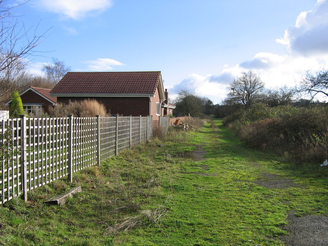
English: North Dorset Trailway at Bailey Gate Crossing The Somerset & Dorset Railway crossed the main A31 (Wimborne - Bere Regis) road at Bailey Gate level crossing, the name coming from a turnpike gate to the west where this road crossed the A350 Poole - Blandford Forum road. In October 2007 the course of the railway south-east from the level crossing and seen here was formally opened as a horse-path, with the intention that it shall be available for walkers and cyclists as well when money can be found for surfacing. Previously there were a signal box and railwaymen's cottage behind the fence to the left but now there is only the modern bungalow. |
| Date | |
| Source | From geograph.org.uk |
| Author | A-M-Jervis |
| Attribution (required by the license) | A-M-Jervis / North Dorset Trailway at Bailey Gate Crossing / |
| Camera location | | View this and other nearby images on: OpenStreetMap |
|---|
_heading:135.00&language=en)
| Object location | | View this and other nearby images on: OpenStreetMap |
|---|
_heading:135.00&language=en)
Licensing
[edit]

|
This image was taken from the Geograph project collection. See this photograph's page on the Geograph website for the photographer's contact details. The copyright on this image is owned by A-M-Jervis and is licensed for reuse under the Creative Commons Attribution-ShareAlike 2.0 license.
|
This file is licensed under the Creative Commons Attribution-Share Alike 2.0 Generic license.
Attribution: A-M-Jervis
- You are free:
- to share – to copy, distribute and transmit the work
- to remix – to adapt the work
- Under the following conditions:
- attribution – You must give appropriate credit, provide a link to the license, and indicate if changes were made. You may do so in any reasonable manner, but not in any way that suggests the licensor endorses you or your use.
- share alike – If you remix, transform, or build upon the material, you must distribute your contributions under the same or compatible license as the original.
File history
Click on a date/time to view the file as it appeared at that time.
| Date/Time | Thumbnail | Dimensions | User | Comment | |
|---|---|---|---|---|---|
| current | 00:53, 23 February 2011 | | 640 × 480 (106 KB) | GeographBot (talk | contribs) | == {{int:filedesc}} == {{Information |description={{en|1=North Dorset Trailway at Bailey Gate Crossing The Somerset & Dorset Railway crossed the main A31 (Wimborne - Bere Regis) road at Bailey Gate level crossing, the name coming from a turnpike gate to t |
You cannot overwrite this file.
File usage on Commons
There are no pages that use this file.