File:Northamptonshire UK location map (1974-2021).svg
Jump to navigation
Jump to search

Size of this PNG preview of this SVG file: 524 × 600 pixels. Other resolutions: 210 × 240 pixels | 419 × 480 pixels | 671 × 768 pixels | 895 × 1,024 pixels | 1,789 × 2,048 pixels | 1,106 × 1,266 pixels.
Original file (SVG file, nominally 1,106 × 1,266 pixels, file size: 2 MB)
Captions
Captions
Add a one-line explanation of what this file represents
| Description |
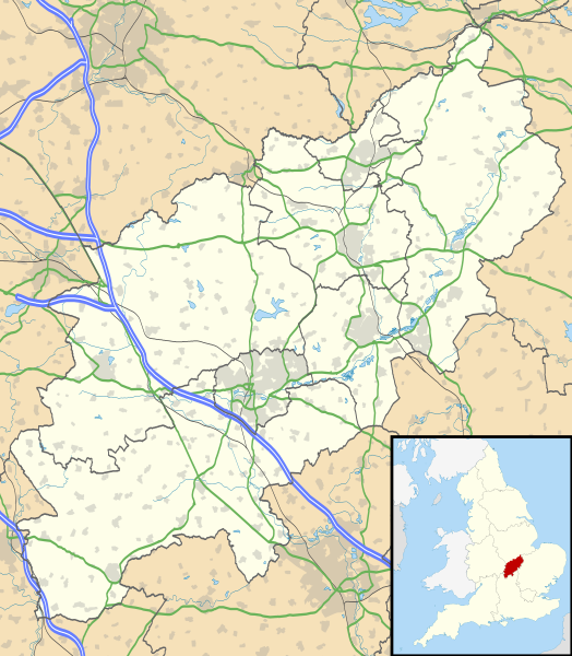
Map of Northamptonshire, UK with the following information shown:
Equirectangular map projection on WGS 84 datum, with N/S stretched 160% Geographic limits:
|
| Date | |
| Source |
|
| Author | Nilfanion, created using Ordnance Survey data |
| Permission (Reusing this file) |
This file is licensed under the Creative Commons Attribution-Share Alike 3.0 Unported license. Attribution: Contains Ordnance Survey data © Crown copyright and database right
|
| Other versions | File:Northamptonshire UK district map (blank).svg - Blank map |
.svg)
File history
Click on a date/time to view the file as it appeared at that time.
| Date/Time | Thumbnail | Dimensions | User | Comment | |
|---|---|---|---|---|---|
| current | 20:59, 21 June 2022 | | 1,106 × 1,266 (2 MB) | G-13114 (talk | contribs) | Reverted to version as of 19:07, 26 September 2010 (UTC) |
| 20:58, 21 June 2022 |  | 1,383 × 1,583 (59 KB) | G-13114 (talk | contribs) | Update to reflect local government boundary changes in 2021 | |
| 19:07, 26 September 2010 |  | 1,106 × 1,266 (2 MB) | Nilfanion (talk | contribs) | {{Information |Description=Map of Northamptonshire, UK with the following information shown: *Administrative borders *Coastline, lakes and rivers *Roads and railways *Urban areas Equirectangular map projection on WGS 84 datum, with |
You cannot overwrite this file.
File usage on Commons
The following 4 pages use this file:
File usage on other wikis
The following other wikis use this file:
- Usage on ar.wikipedia.org
- Usage on bg.wikipedia.org
- Usage on ceb.wikipedia.org
- Usage on cy.wikipedia.org
- Usage on es.wikipedia.org
- Northampton
- Northamptonshire
- Silverstone
- Corby
- Plantilla:Mapa de localización de Northamptonshire
- Rockingham (Northamptonshire)
- Cottingham (Northamptonshire)
- Middleton (Northamptonshire)
- Weldon (Northamptonshire)
- Gretton (Northamptonshire)
- Stanion
- East Carlton
- Wilbarston
- Weston by Welland
- Weekley
- Warkton
- Thorpe Malsor
- Stoke Albany
- Harrington (Northamptonshire)
- Harringworth
- Earls Barton
- East Farndon
- East Haddon
- Easton on the Hill
- Ecton
- Evenley
- Everdon
- Eydon
- Quinton (Northamptonshire)
- Guilsborough
- Aynho
- Aston le Walls
- Yardley Gobion
- Irchester
- Isham
- Scaldwell
- Shutlanger
- Sibbertoft
- Islip (Northamptonshire)
- Yardley Hastings
- Yarwell
- Yelvertoft
- Wilby (Northamptonshire)
- Badby
- Barby (Northamptonshire)
- Barnwell (Northamptonshire)
View more global usage of this file.
.svg)
.svg&oldid=737313553)