File:Nouveau plan de Paris et des communes de la banlieue by A. Vuillemin - Stanford Libraries - Original.jpg
Jump to navigation
Jump to search

Size of this preview: 792 × 600 pixels. Other resolutions: 317 × 240 pixels | 634 × 480 pixels | 1,014 × 768 pixels | 1,280 × 969 pixels | 2,560 × 1,939 pixels | 22,798 × 17,266 pixels.
Original file (22,798 × 17,266 pixels, file size: 103.85 MB, MIME type: image/jpeg)
Captions
Captions
Add a one-line explanation of what this file represents

|
This file has been superseded by Nouveau plan de Paris et des communes de la banlieue by A. Vuillemin - Stanford Libraries.jpg. It is recommended to use the other file. Please note that deleting superseded images requires consent.
|

|
Summary[edit]
| Warning | The original file is very high-resolution. It might not load properly or could cause your browser to freeze when opened at full size. |
|---|
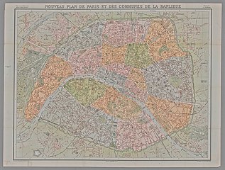
| Title |
Nouveau Plan de Paris et des communes de la banlieue |
| Date | |
| Source | Stanford Libraries |
| Creator |
Alexandre Vuillemin |
| Georeferencing | If inappropriate please set warp_status = skip to hide. |
| Bibliographic data | |
| Printed by |
Paris : Garnier frères, [188-] |
| Archival data | |
| Collection | Stanford Libraries |
| Dimensions | 63 x 82 cm |
| Medium | 1 map |
| Notes |
Vingt arrondissements. Quatre-vingts quartiers. Grave par A.Simon. |
Licensing[edit]
|
This work is in the public domain in its country of origin and other countries and areas where the copyright term is the author's life plus 100 years or fewer. | |
| This file has been identified as being free of known restrictions under copyright law, including all related and neighboring rights. | |
File history
Click on a date/time to view the file as it appeared at that time.
| Date/Time | Thumbnail | Dimensions | User | Comment | |
|---|---|---|---|---|---|
| current | 13:16, 14 July 2020 | | 22,798 × 17,266 (103.85 MB) | Paris 16 (talk | contribs) | Uploaded own work with UploadWizard |
You cannot overwrite this file.
File usage on Commons
The following 3 pages use this file: