File:Nouvelle-France map-en.svg
跳转到导航
跳转到搜索

此SVG文件的PNG预览的大小:800 × 570像素。 其他分辨率:320 × 228像素 | 640 × 456像素 | 1,024 × 730像素 | 1,280 × 912像素 | 2,560 × 1,824像素 | 1,530 × 1,090像素。
原始文件 (SVG文件,尺寸为1,530 × 1,090像素,文件大小:586 KB)
说明
说明
添加一行文字以描述该文件所表现的内容
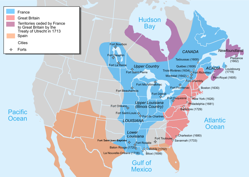
Map of New France about 1750 using modern political boundaries - English Version
摘要
[编辑]| 描述 |
Català: Mapa de la Nova França sobre 1754-1755 English: Map of New France about 1750 using modern political boundaries Español: Mapa de la Nueva Francia cerca de 1750. Français : Carte de la Nouvelle-France vers 1754-1755 Norsk nynorsk: Kart over Ny Frankrike (ca 1754-1755) Русский: Карта Французских колоний в Америке 1750 中文(中国大陆): 1750年左右的新法兰西地图,附现代边界。 العربية : خريطة فرنسا الجديدة حوالي عام 1750 باستخدام الحدود السياسية الحديثة |
||
| 日期 | |||
| 来源 |
个人作品,使用:
|
||
| 作者 | Pinpin | ||
| 其他版本 |
[]
|


|
此SVG檔案包含可翻譯至您的語言的内嵌文字,可以使用任何可用SVG編輯器、文本編輯器或SVG翻譯工具來翻譯。詳情請見:關於翻譯SVG檔案。 |
许可协议
[编辑]
我,本作品著作权人,特此采用以下许可协议发表本作品:

|
已授权您依据自由软件基金会发行的无固定段落及封面封底文字(Invariant Sections, Front-Cover Texts, and Back-Cover Texts)的GNU自由文件许可协议1.2版或任意后续版本的条款,复制、传播和/或修改本文件。该协议的副本请见“GNU Free Documentation License”。 |
- 您可以自由地:
- 共享 – 复制、发行并传播本作品
- 修改 – 改编作品
- 惟须遵守下列条件:
- 署名 – 您必须对作品进行署名,提供授权条款的链接,并说明是否对原始内容进行了更改。您可以用任何合理的方式来署名,但不得以任何方式表明许可人认可您或您的使用。
- 相同方式共享 – 如果您再混合、转换或者基于本作品进行创作,您必须以与原先许可协议相同或相兼容的许可协议分发您贡献的作品。
您可以选择您需要的许可协议。
文件历史
点击某个日期/时间查看对应时刻的文件。
| 日期/时间 | 缩略图 | 大小 | 用户 | 备注 | |
|---|---|---|---|---|---|
| 当前 | 2022年12月27日 (二) 22:23 | | 1,530 × 1,090(586 KB) | Tcr25(留言 | 贡献) | remove stray circle from Saskatchewan |
| 2022年12月14日 (三) 16:09 |  | 1,530 × 1,090(586 KB) | Tcr25(留言 | 贡献) | plain SVG instead of Inkscape | |
| 2021年9月21日 (二) 13:24 |  | 1,530 × 1,090(590 KB) | Tcr25(留言 | 贡献) | Placed Fort Rosalie in proper location; added Fort St. Jean Baptiste (Natchitoches) | |
| 2013年10月10日 (四) 14:11 |  | 1,530 × 1,090(550 KB) | Begoon(留言 | 贡献) | Reverted to version as of 14:02, 10 October 2013 | |
| 2013年10月10日 (四) 14:08 |  | 1,530 × 1,090(265 KB) | Begoon(留言 | 贡献) | revert to compare rsvg render | |
| 2013年10月10日 (四) 14:02 |  | 1,530 × 1,090(550 KB) | Begoon(留言 | 贡献) | revert for now - I'll play some more... | |
| 2013年10月10日 (四) 13:58 |  | 1,530 × 1,090(265 KB) | Begoon(留言 | 贡献) | tweak a couple of label positions | |
| 2013年10月10日 (四) 13:53 |  | 1,530 × 1,090(265 KB) | Begoon(留言 | 贡献) | actually - something spooky about this file ever since gradient was changed. I'm reverting to version with gradient, because it's consistent with other maps in series. Subsequent change to Fort Toulouse replicated, Mexico landmass added, layers fixed. | |
| 2013年10月10日 (四) 13:10 |  | 1,530 × 1,090(550 KB) | Begoon(留言 | 贡献) | cities layer is wrong - try again | |
| 2013年10月10日 (四) 11:35 |  | 1,530 × 1,090(633 KB) | Begoon(留言 | 贡献) | fix layers after addition |
您不可以覆盖此文件。
文件用途
以下15个页面使用本文件:
- User:Magog the Ogre/Multilingual legend/2021 September 21-30
- User:Magog the Ogre/Multilingual legend/2022 December 11-20
- User:Magog the Ogre/Multilingual legend/2022 December 21-31
- File:Neufrankreich.svg
- File:New-France1750.png
- File:Nouvelle-France map-ar.svg
- File:Nouvelle-France map-ca.svg
- File:Nouvelle-France map-en.svg
- File:Nouvelle-France map-es.svg
- File:Nouvelle-France map-fr.svg
- File:Nouvelle-France map-he.svg
- File:Nouvelle-France map-ru.svg
- File:Nouvelle-France map-zh-hans.svg
- Template:Other versions/Nouvelle-France map
- Category:French colonization of the Americas
全域文件用途
以下其他wiki使用此文件:
- af.wikipedia.org上的用途
- an.wikipedia.org上的用途
- ar.wikipedia.org上的用途
- arz.wikipedia.org上的用途
- azb.wikipedia.org上的用途
- az.wikipedia.org上的用途
- bg.wikipedia.org上的用途
- bn.wikipedia.org上的用途
- bn.wikibooks.org上的用途
- cs.wikipedia.org上的用途
- cy.wikipedia.org上的用途
- da.wikipedia.org上的用途
- en.wikipedia.org上的用途
- Canada–United States relations
- Louisiana
- Mississippi River
- French and Indian War
- Louis XV
- History of the United States
- Queen Anne's War
- New France
- Peace of Utrecht
- Military history of Canada
- History of Pennsylvania
- Northern Michigan
- Louisiana (New France)
- Spanish Texas
- French Americans
- United States
- History of Michigan
- Portal:Michigan
- Louisiana Creole people
- French immigration to Puerto Rico
- Canada
- History of St. Louis
- History of Louisiana
- Portal:Canada/Selected picture
- Portal:Pennsylvania
- Outline of the history of the United States
查看此文件的更多全域用途。