File:Ocean currents 1943 (borderless)3.png
跳转到导航
跳转到搜索

本预览的尺寸:800 × 405像素。 其他分辨率:320 × 162像素 | 640 × 324像素 | 1,024 × 519像素 | 1,280 × 649像素 | 2,577 × 1,306像素。
原始文件 (2,577 × 1,306像素,文件大小:2.41 MB,MIME类型:image/png)
说明
说明
添加一行文字以描述该文件所表现的内容

|
此meteorology图片可使用矢量图形重新创建为SVG文件。这具有很多好处;更多信息请参见共享资源:待清理媒体。如果存在此图片的SVG格式,请将其上传,然后将此模板替换为
{{vector version available|新图片名称}}。
建议您将SVG命名为“Ocean currents 1943 (borderless)3.svg”,这样在使用Vector version available(或Vva)模板时就不需要填写新图片名称参数。 |
摘要
[编辑]| 描述 |
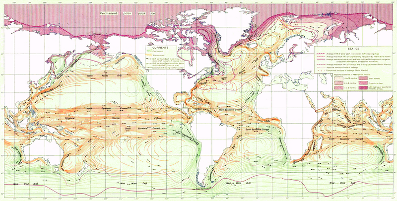
English: Ocean Currents and Sea Ice from Atlas of World Maps, United States Army Service Forces, Army Specialized Training Division. Army Service Forces Manual M-101 (1943).
Türkçe: Dünyanın büyük akıntılarının şeması |
|||
| 日期 | ||||
| 来源 | Edited version of File:Ocean currents 1943 (borderless).png | |||
| 作者 | US army | |||
| 授权 (二次使用本文件) |
|
|||
| 其他版本 |
本文件衍生自: Ocean currents 1943 (borderless).png (For more versions see there) |

.png)
3.png&action=edit§ion=1)
.png)
| 这是一张修改过的图片,这意味着它已在原版本的基础上通过软件进行了编辑,改动内容:landmass interiors clarified, some latitude and longitude lines repaired, bottom longitudinal numbering replaced, and a stray pencil mark through the Indian Ocean removed。其原始版本为:Ocean currents 1943 (borderless).png。修改者:Jrockley。
|
评价
[编辑]3.png&action=edit§ion=2)
3.png)
文件历史
点击某个日期/时间查看对应时刻的文件。
| 日期/时间 | 缩略图 | 大小 | 用户 | 备注 | |
|---|---|---|---|---|---|
| 当前 | 2012年2月2日 (四) 21:18 | | 2,577 × 1,306(2.41 MB) | Mahahahaneapneap(留言 | 贡献) | Compressed again. Please don't revert unless you can give a reason why. |
| 2012年1月19日 (四) 21:48 |  | 2,577 × 1,306(3.4 MB) | The ed17(留言 | 贡献) | there is no reason to compress this | |
| 2011年12月24日 (六) 18:27 |  | 2,577 × 1,306(2.41 MB) | Mahahahaneapneap(留言 | 贡献) | Compressed. Identical image, 1 MB smaller. | |
| 2009年9月4日 (五) 14:34 |  | 2,577 × 1,306(3.4 MB) | Durova(留言 | 贡献) | Reverted to version as of 08:15, 27 June 2008 reverting arbitrary compression | |
| 2008年10月17日 (五) 20:54 |  | 2,577 × 1,306(2.41 MB) | Mahahahaneapneap(留言 | 贡献) | Compressed | |
| 2008年6月27日 (五) 08:15 |  | 2,577 × 1,306(3.4 MB) | Durova(留言 | 贡献) | {{Information |Description=''Ocean Currents and Sea Ice from Atlas of World Maps'', United States Army Service Forces, Army Specialized Training Division. Army Service Forces Manual M-101 (1943). |Source=http://www.lib.utexas.edu/maps/world_maps/ocean |
您不可以覆盖此文件。
文件用途
以下3个页面使用本文件:
全域文件用途
以下其他wiki使用此文件:
- ar.wikipedia.org上的用途
- ast.wikipedia.org上的用途
- az.wikipedia.org上的用途
- be.wikipedia.org上的用途
- bg.wikipedia.org上的用途
- bn.wikipedia.org上的用途
- ca.wikipedia.org上的用途
- da.wikipedia.org上的用途
- el.wikipedia.org上的用途
- en.wikipedia.org上的用途
- Ocean current
- Portal:Maps/Selected picture
- History of navigation
- Wikipedia:Featured pictures thumbs/12
- Wikipedia:Featured pictures/Diagrams, drawings, and maps/Maps
- User:Shoemaker's Holiday
- Wikipedia:Featured picture candidates/File:Ocean currents 1943 (borderless)3.png
- Wikipedia:Featured picture candidates/July-2008
- Wikipedia:Wikipedia Signpost/2008-07-07/Features and admins
- User talk:Durova/Archive 60
- Wikipedia:Wikipedia Signpost/2008-08-25/Features and admins
- Wikipedia:Wikipedia Signpost/2008-08-25/SPV
- Wikipedia:Wikipedia Signpost/2008-07-07/SPV
- Portal:Maps/Selected picture/37
- User talk:Shoemaker's Holiday/Archive 2
- Flow map
- Wikipedia:Picture of the day/January 2009
- Template:POTD/2009-01-05
- User talk:Durova/Archive 64
- User:Adam Cuerden
- User:Durova/Featured picture gallery/2008
- Wikipedia:WikiProject United States/Recognized content
- Wikipedia:WikiProject United States/Quality content
- Wikipedia:WikiProject United States/Featured pictures
- Wikipedia:Wikipedia Signpost/Single/2008-07-07
- Wikipedia:Wikipedia Signpost/Single/2008-08-25
- es.wikipedia.org上的用途
- fa.wikipedia.org上的用途
- hi.wikipedia.org上的用途
- hu.wikipedia.org上的用途
- ka.wikipedia.org上的用途
- lv.wikipedia.org上的用途
- mr.wikipedia.org上的用途
- oc.wikipedia.org上的用途
3.png)
查看此文件的更多全域用途。
3.png)
3.png&oldid=691505207)