File:Ohio Country en.png
ナビゲーションに移動
検索に移動
このプレビューのサイズ: 793 × 599 ピクセル。 その他の解像度: 318 × 240 ピクセル | 635 × 480 ピクセル | 1,016 × 768 ピクセル | 1,217 × 920 ピクセル。
元のファイル (1,217 × 920 ピクセル、ファイルサイズ: 1.41メガバイト、MIME タイプ: image/png)
キャプション
キャプション
このファイルの内容を1行で記述してください
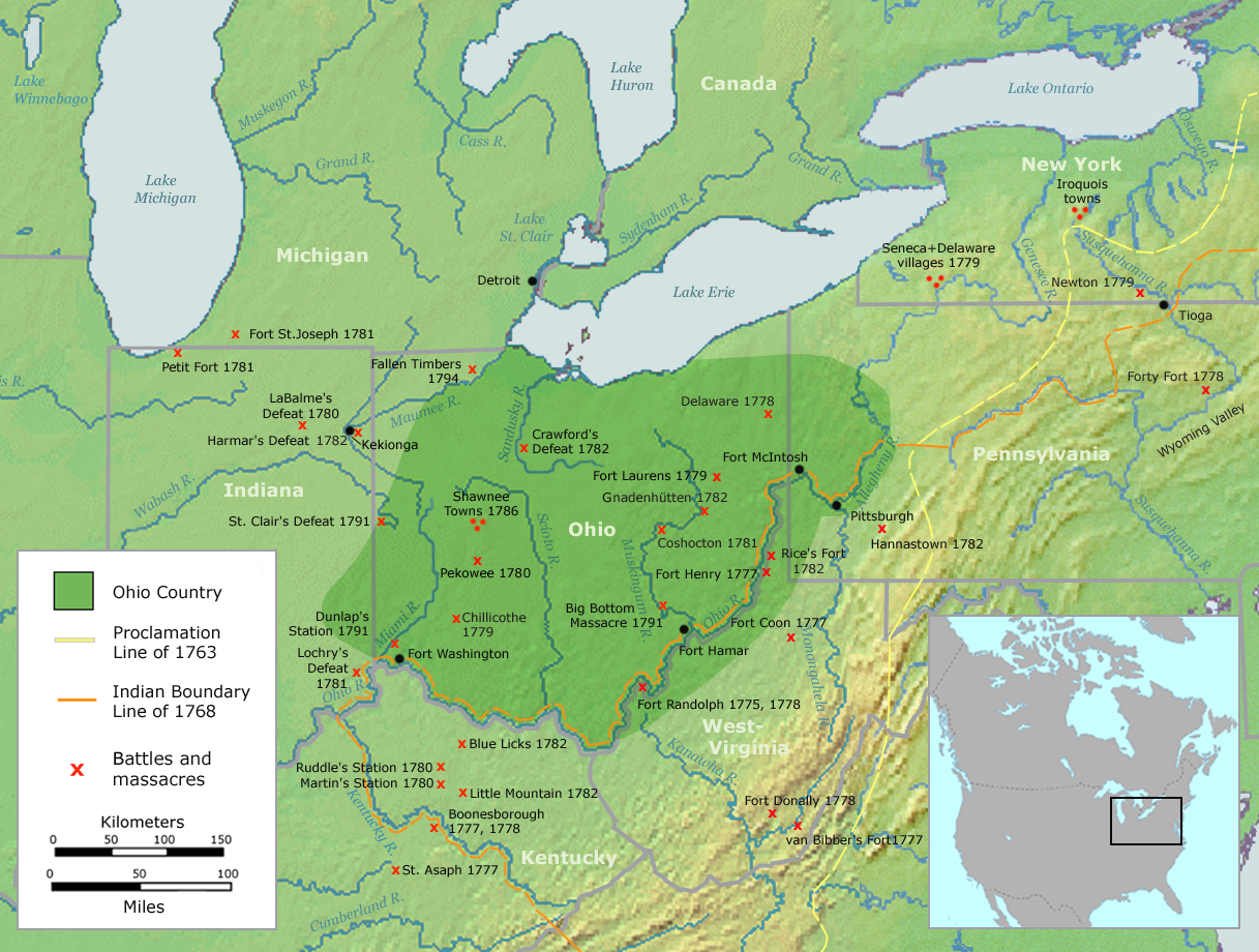
Map of the Ohio Country
| 解説 | Map of the Ohio Country (English version) | ||||
| 日付 | |||||
| 原典 | Own work by Nikater, submitted to the public domain. Background map courtesy of Demis, www.demis.nl and Wilcomb E. Washburn (Hrsg.) Handbook of North American Indians. Vol. 4: History of Indian-White Relations. Smithsonian Institution Press, Washington D.C. 1988. ISBN 0-16004-583-5 | ||||
| 作者 | User:Nikater | ||||
| 許可 (ファイルの再利用) |
|
||||
| その他のバージョン | Deutsch |
ファイルの履歴
過去の版のファイルを表示するには、その版の日時をクリックしてください。
| 日付と時刻 | サムネイル | 寸法 | 利用者 | コメント | |
|---|---|---|---|---|---|
| 現在の版 | 2007年9月21日 (金) 06:20 | | 1,217 × 920 (1.41メガバイト) | Nikater (トーク | 投稿記録) | {{Information |Description=Map of the Ohio Country (English version) |Source=Own work by Nikater, submitted to the public domain. Background map courtesy of Demis, www.demis.nl and Wilcomb E. Washburn (Hrsg.) ''Handbook of North American Indians.'' Vol. 4 |
| 2007年9月20日 (木) 11:50 |  | 1,217 × 920 (1.41メガバイト) | Nikater (トーク | 投稿記録) | {{Information |Description=Map of the Ohio Country (English version) |Source=Own work by Nikater, submitted to the public domain. Background map courtesy of Demis, www.demis.nl and Wilcomb E. Washburn (Hrsg.) ''Handbook of North American Indians.'' Vol. 4 | |
| 2007年9月17日 (月) 20:21 |  | 1,217 × 920 (1.41メガバイト) | Nikater (トーク | 投稿記録) | {{Information |Description=Map of the Ohio Country (English version) |Source=Own work by Nikater, submitted to the public domain. Background map courtesy of Demis, www.demis.nl and Wilcomb E. Washburn (Hrsg.) ''Handbook of North American Indians.'' Vol. 4 | |
| 2007年9月17日 (月) 20:05 |  | 1,217 × 920 (1.41メガバイト) | Nikater (トーク | 投稿記録) | {{Information |Description=Map of the Ohio Country (English version) |Source=Own work by Nikater, submitted to the public domain. Background map courtesy of Demis, www.demis.nl and Wilcomb E. Washburn (Hrsg.) ''Handbook of North American Indians.'' Vol. 4 |
このファイルは上書きできません。
ファイルの使用状況
以下のページがこのファイルを使用しています:
グローバルなファイル使用状況
以下に挙げる他のウィキがこの画像を使っています:
- ar.wikipedia.org での使用状況
- arz.wikipedia.org での使用状況
- ast.wikipedia.org での使用状況
- bn.wikipedia.org での使用状況
- ca.wikipedia.org での使用状況
- cs.wikipedia.org での使用状況
- en.wikipedia.org での使用状況
- es.wikipedia.org での使用状況
- fr.wikipedia.org での使用状況
- gl.wikipedia.org での使用状況
- id.wikipedia.org での使用状況
- ja.wikipedia.org での使用状況
- ko.wikipedia.org での使用状況
- ms.wikipedia.org での使用状況
- no.wikipedia.org での使用状況
- pl.wikipedia.org での使用状況
- ro.wikipedia.org での使用状況
- ru.wikipedia.org での使用状況
- so.wikipedia.org での使用状況
- sq.wikipedia.org での使用状況
- sv.wikipedia.org での使用状況
- tr.wikipedia.org での使用状況
- www.wikidata.org での使用状況
カテゴリ:
- Maps of the history of the United States
- Maps of Native American tribal territories
- Battles involving Native Americans in the 18th century
- Ohio Country
- Handbook of North American Indians
- History of indigenous peoples of the Great Lakes Region
- Battles in Ohio
- Battles in Indiana
- Battles in Michigan
- Battles in Pennsylvania
- Battles in New York (state)
- Battles in Kentucky
- Battles in West Virginia
- Maps of the Northwest Indian War
- Kekionga
- Munsee
- Hannastown, Pennsylvania
- Maps of the history of Ohio
- Maps of the history of Indiana
- Maps of the history of Kentucky
- 18th-century maps of the United States