File:Old Oswestry Hillfort (aerial).jpg
跳至導覽
跳至搜尋
無更高解析度可提供。
Old_Oswestry_Hillfort_(aerial).jpg (640 × 394 像素,檔案大小:138 KB,MIME 類型:image/jpeg)
說明
說明
添加單行說明來描述出檔案所代表的內容
摘要
[編輯].jpg&action=edit§ion=1)
| 描述 |
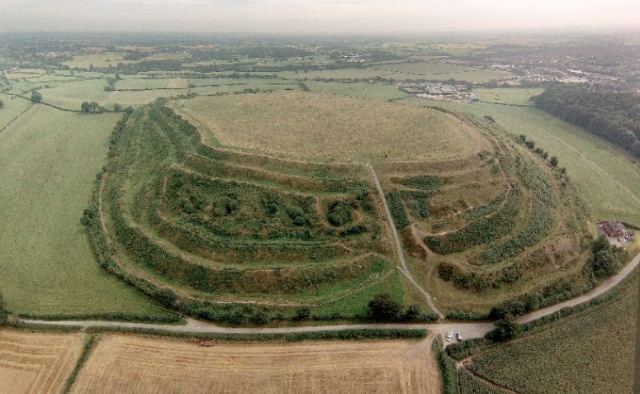
English: Old Oswestry Hillfort. Above and looking along the entrance to the Hillfort and across Shropshire. Intersecting with Wat's Dyke. |
| 日期 | |
| 來源 | https://www.geograph.org.uk/photo/3724089 |
| 作者 | Oswestry Borderland Tourism |
| 姓名標示 (由许可协议要求) | Credit Oswestry Borderland Tourism / Old Oswestry Hillfort / |
| 拍攝地點 | | 位於此地的本圖片與其他圖片: OpenStreetMap |
|---|
.jpg¶ms=052.871285_N_-002.949838_E_globe:Earth_type:camera_heading:90.00&language=zh-mo)
授權條款
[編輯].jpg&action=edit§ion=2)

|
此圖像來自Geograph工程圖集。攝影師的聯繫資訊請見Geograph網站上該照片的頁面。此圖像的著作權人為Credit Oswestry Borderland Tourism,採用創用CC 署名-相同方式共享 2.0許可協議授權二次使用。
|
此檔案採用共享創意 姓名標示-相同方式分享 2.0 通用版授權條款。
姓名標示: Credit Oswestry Borderland Tourism
- 您可以自由:
- 分享 – 複製、發佈和傳播本作品
- 重新修改 – 創作演繹作品
- 惟需遵照下列條件:
- 姓名標示 – 您必須指名出正確的製作者,和提供授權條款的連結,以及表示是否有對內容上做出變更。您可以用任何合理的方式來行動,但不得以任何方式表明授權條款是對您許可或是由您所使用。
- 相同方式分享 – 如果您利用本素材進行再混合、轉換或創作,您必須基於如同原先的相同或兼容的條款,來分布您的貢獻成品。
檔案歷史
點選日期/時間以檢視該時間的檔案版本。
| 日期/時間 | 縮圖 | 尺寸 | 用戶 | 備註 | |
|---|---|---|---|---|---|
| 目前 | 2017年4月7日 (五) 09:02 | | 640 × 394(138 KB) | Emerald-wiki(對話 | 貢獻) | User created page with UploadWizard |
無法覆蓋此檔案。
檔案用途
下列2個頁面有用到此檔案:
全域檔案使用狀況
以下其他 wiki 使用了這個檔案:
- de.wikipedia.org 的使用狀況
- en.wikipedia.org 的使用狀況
- en.wikivoyage.org 的使用狀況
- he.wikipedia.org 的使用狀況
- www.wikidata.org 的使用狀況
- zh.wikipedia.org 的使用狀況
.jpg&oldid=881051772)