File:Old Royal Infirmary from the Meadows - geograph.org.uk - 1529753.jpg
Jump to navigation
Jump to search
No higher resolution available.
Old_Royal_Infirmary_from_the_Meadows_-_geograph.org.uk_-_1529753.jpg (640 × 480 pixels, file size: 77 KB, MIME type: image/jpeg)
Captions
Captions
Add a one-line explanation of what this file represents
Summary
[edit]
| Description |
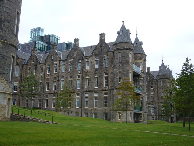
English: Old Royal Infirmary from the Meadows Wing of the former Royal Infirmary, recently converted into private residences. Note the balconies where the beds of TB sufferers were placed overnight to provide them with fresh air. |
| Date | |
| Source | From geograph.org.uk |
| Author | kim traynor |
| Attribution (required by the license) | kim traynor / Old Royal Infirmary from the Meadows / |
| Camera location | | View this and other nearby images on: OpenStreetMap |
|---|
_heading:22.00&language=en)
| Object location | | View this and other nearby images on: OpenStreetMap |
|---|
_heading:22.00&language=en)
Licensing
[edit]

|
This image was taken from the Geograph project collection. See this photograph's page on the Geograph website for the photographer's contact details. The copyright on this image is owned by kim traynor and is licensed for reuse under the Creative Commons Attribution-ShareAlike 2.0 license.
|
This file is licensed under the Creative Commons Attribution-Share Alike 2.0 Generic license.
Attribution: kim traynor
- You are free:
- to share – to copy, distribute and transmit the work
- to remix – to adapt the work
- Under the following conditions:
- attribution – You must give appropriate credit, provide a link to the license, and indicate if changes were made. You may do so in any reasonable manner, but not in any way that suggests the licensor endorses you or your use.
- share alike – If you remix, transform, or build upon the material, you must distribute your contributions under the same or compatible license as the original.
File history
Click on a date/time to view the file as it appeared at that time.
| Date/Time | Thumbnail | Dimensions | User | Comment | |
|---|---|---|---|---|---|
| current | 03:51, 3 March 2011 | | 640 × 480 (77 KB) | GeographBot (talk | contribs) | == {{int:filedesc}} == {{Information |description={{en|1=Old Royal Infirmary from the Meadows Wing of the former Royal Infirmary, recently converted into private residences. Note the balconies where the beds of TB sufferers were placed overnight to provid |
You cannot overwrite this file.
File usage on Commons
There are no pages that use this file.