File:Old railway stations of Hamburg.svg
跳转到导航
跳转到搜索

此SVG文件的PNG预览的大小:544 × 600像素。 其他分辨率:218 × 240像素 | 435 × 480像素 | 696 × 768像素 | 928 × 1,024像素 | 1,857 × 2,048像素 | 680 × 750像素。
原始文件 (SVG文件,尺寸为680 × 750像素,文件大小:4 KB)
说明
说明
添加一行文字以描述该文件所表现的内容
| 描述 |
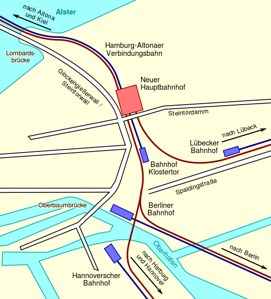
Deutsch: Diese Karte zeigt die historischen Endbahnhöfe in Hamburg: Den Lübecker, Berliner und Hannoverschen Bahnhof und den Bahnhof Klostertor sowie, in blau, die zu diesen Bahnhöfen führenden Eisenbahnstrecken. Weiterhin zeigt es den neuen Hauptbahnhof, der die alten Endbahnhöfe ersetzt, und (in braun) die neue Linienführung, welche die in Hamburg endenden Eisenbahnstrecken an den Hauptbahnhof heranführt.
English: This map shows the historic railways terminuses of Hamburg: Lübecker, Berliner, Hannoverscher Bahnhof, and Bahnhof Klostertor, and, in blue, the railway lines leading to these stations. It also shows the new Central Station that was built to replace these terminuses, and, in brown, the new railtrack arrangement connecting the Central Station to the railway lines ending in Hamburg. |
| 日期 | |
| 来源 |
Deutsch: Gezeichnet nach einer Vorlage von de:Benutzer:WHell, um diese zu ersetzen.
English: Drawn in accordance with, and in order to replace, a map of user de:Benutzer:WHell. |
| 作者 | Sebastian Koppehel, User:SKopp |
| 授权 (二次使用本文件) |
|
| 其他版本 |
|


文件历史
点击某个日期/时间查看对应时刻的文件。
| 日期/时间 | 缩略图 | 大小 | 用户 | 备注 | |
|---|---|---|---|---|---|
| 当前 | 2012年8月5日 (日) 14:11 | | 680 × 750(4 KB) | Perhelion(留言 | 贡献) | bit stil, opt |
| 2012年8月5日 (日) 13:55 |  | 680 × 750(5 KB) | Perhelion(留言 | 贡献) | fix: bigger font, opt | |
| 2007年2月22日 (四) 06:57 |  | 680 × 750(48 KB) | SKopp(留言 | 贡献) | {{Information |Description=A map showing the old railway terminuses of Hamburg, and the new Central Station that replaced them. |Source=Drawn in accordance with de:Bild:HH-Bhf-hh.jpg |Date=2007-02-22 |Author=Sebastian Koppehel |Permission={{cc-by-2.0 |
您不可以覆盖此文件。
文件用途
以下页面使用本文件:
全域文件用途
以下其他wiki使用此文件:
- de.wikipedia.org上的用途
- ja.wikipedia.org上的用途
- nl.wikipedia.org上的用途
- zh.wikipedia.org上的用途