File:OrteliusWorldMap.jpeg
跳至導覽
跳至搜尋
預覽大小:800 × 545 像素。 其他解析度:320 × 218 像素 | 640 × 436 像素 | 1,024 × 697 像素 | 1,280 × 872 像素 | 2,560 × 1,744 像素 | 5,788 × 3,942 像素。
原始檔案 (5,788 × 3,942 像素,檔案大小:25.02 MB,MIME 類型:image/jpeg)
說明
說明
添加單行說明來描述出檔案所代表的內容
jakkrit kaewtoom
摘要
[編輯]| 描述 |
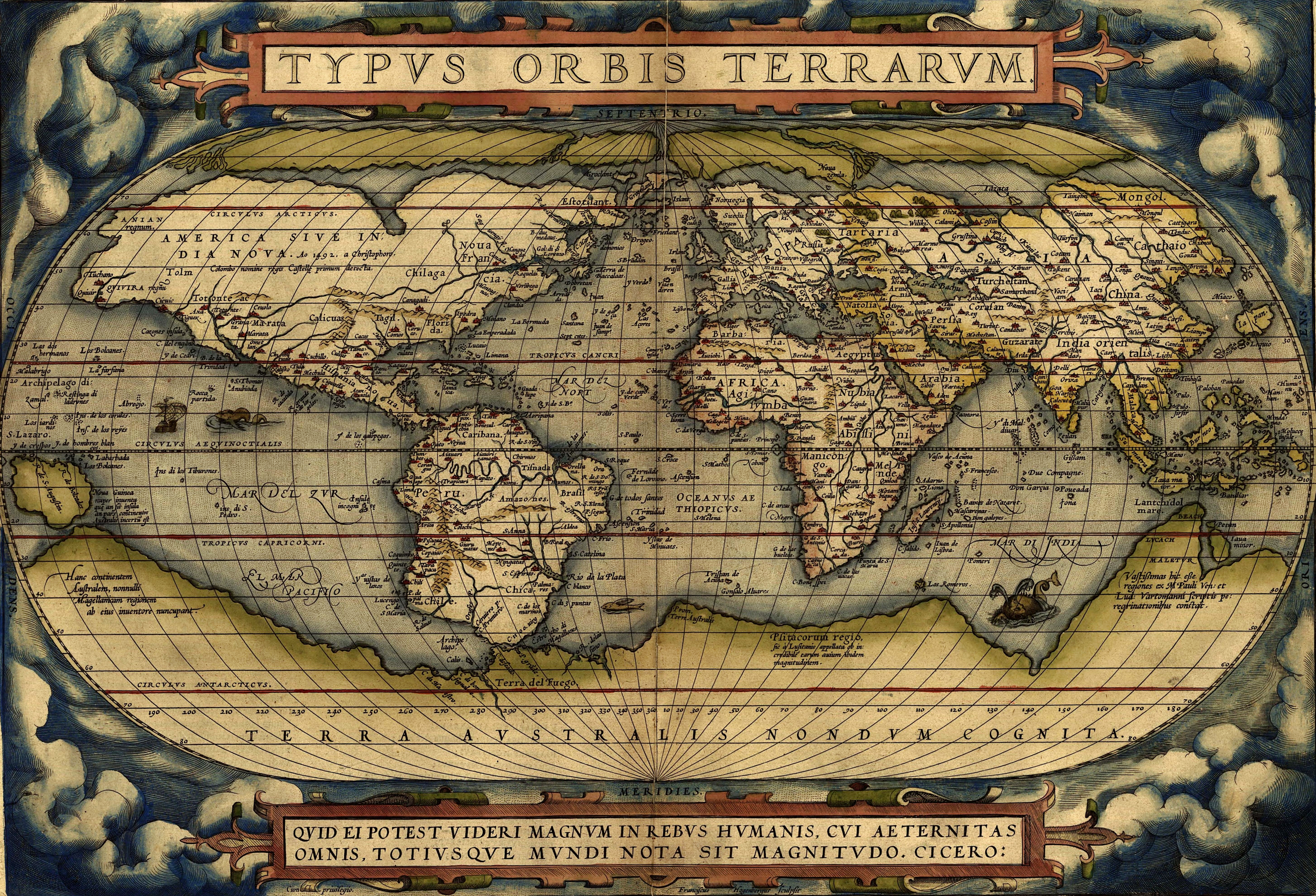
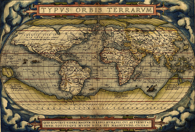
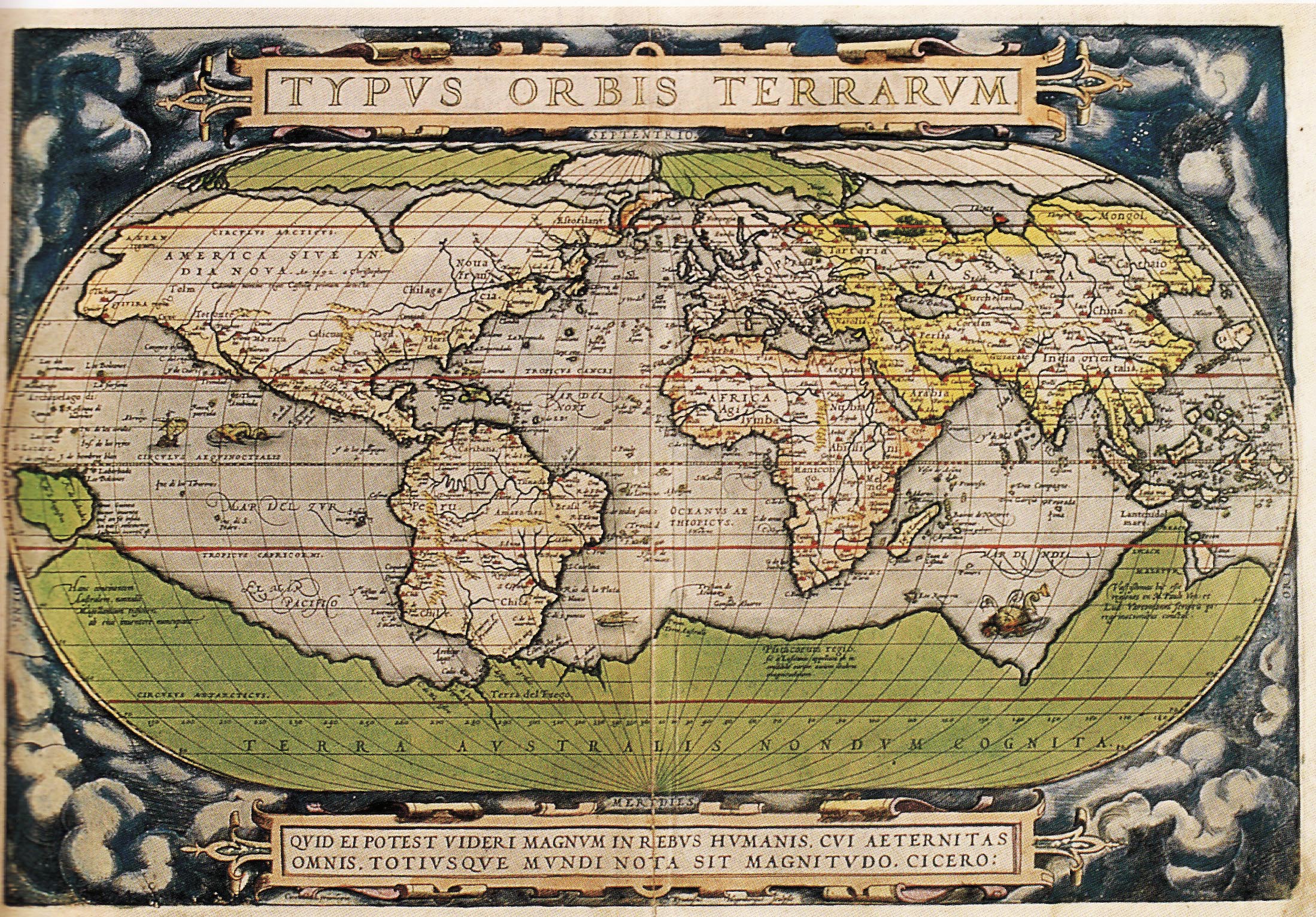
English: Ortelius world map 1570
Español: Mapa Mundial de Ortelius, 1570
Türkçe: Ortelius'un dünya haritası, 1570
עברית: מפת העולם מתוך אטלס אורטליוס |
||
| 日期 | |||
| 來源 | http://www.britishempire.co.uk/images4/ortelius1570maplarge.jpg | ||
| 作者 | |||
| 其他版本 |
|


授權條款
[編輯]
|
此為如實地拍攝平面藝術品的相片複製本。原作位於公有領域,是因下列原因:
維基媒體基金會的官方立場認為:「針對平面公有領域的藝術作品進行忠實重製,其重製後的照片也屬於公有領域。」
因此,可認定本重製照片屬於公有領域。在其他司法管轄區,再利用此照片可能會被限制;參見再利用PD-Art照片以獲得進一步資訊。 | ||||
檔案歷史
點選日期/時間以檢視該時間的檔案版本。
| 日期/時間 | 縮圖 | 尺寸 | 用戶 | 備註 | |
|---|---|---|---|---|---|
| 目前 | 2024年6月23日 (日) 14:12 | | 5,788 × 3,942(25.02 MB) | ArionStar(對話 | 貢獻) | Reverted to version as of 08:47, 18 June 2024 (UTC) |
| 2024年6月22日 (六) 02:20 |  | 5,788 × 3,942(26.95 MB) | Billinghurst(對話 | 貢獻) | Reverted to version as of 08:37, 1 February 2015 (UTC) | |
| 2024年6月18日 (二) 08:47 |  | 5,788 × 3,942(25.02 MB) | Yann(對話 | 貢獻) | c:User:Rillke/bigChunkedUpload.js: edit by Cart | |
| 2015年2月1日 (日) 08:37 |  | 5,788 × 3,942(26.95 MB) | Hello world(對話 | 貢獻) | new | |
| 2015年2月1日 (日) 08:30 |  | 2,198 × 1,532(6.79 MB) | Hello world(對話 | 貢獻) | new | |
| 2015年2月1日 (日) 08:23 |  | 2,198 × 1,532(6.79 MB) | Hello world(對話 | 貢獻) | new | |
| 2005年6月13日 (一) 11:46 |  | 616 × 424(100 KB) | ¡0-8-15!(對話 | 貢獻) | Ortelius world map 1570 {{PD-Old}} |
無法覆蓋此檔案。
檔案用途
超過 100 個頁面有用到此檔案。 下列清單只列出前 100 筆有用到此檔案的頁面。 您也可以檢視完整清單。
- Facsimile atlas
- Maps of the world
- Old maps
- User:Kanchelskis/Atlante
- User talk:¡0-8-15!
- Commons:Featured pictures/Non-photographic media/Maps
- File:1570 Typus Ortelius mr.jpg
- File:1572 Typus Orbis Terrarum Ortelius.jpg
- Category:Geography
- Category:Geography by continent
- Category:Geography by country
- Category:Geography of Achaea
- Category:Geography of Anhui
- Category:Geography of Bavaria
- Category:Geography of Cantabria
- Category:Geography of Carinthia
- Category:Geography of Central Europe
- Category:Geography of Chukotka
- Category:Geography of Crimea
- Category:Geography of Dagestan
- Category:Geography of Eastern Europe
- Category:Geography of Friesland
- Category:Geography of Friuli-Venezia Giulia
- Category:Geography of Fujian
- Category:Geography of Gansu
- Category:Geography of Guangxi
- Category:Geography of Guizhou
- Category:Geography of Hainan
- Category:Geography of Hebei
- Category:Geography of Heilongjiang
- Category:Geography of Henan
- Category:Geography of Hubei
- Category:Geography of Indre-et-Loire
- Category:Geography of Inner Mongolia
- Category:Geography of Jiangxi
- Category:Geography of Kabardino-Balkaria
- Category:Geography of Kaliningrad Oblast
- Category:Geography of Karachay-Cherkessia
- Category:Geography of Karelia
- Category:Geography of Khakassia
- Category:Geography of Kirov Oblast
- Category:Geography of Komi
- Category:Geography of Krasnodar Krai
- Category:Geography of La Palma
- Category:Geography of Lower Saxony
- Category:Geography of Mecklenburg-Vorpommern
- Category:Geography of Mordovia
- Category:Geography of Moscow Oblast
- Category:Geography of Munich
- Category:Geography of Murmansk Oblast
- Category:Geography of Neuquén Province
- Category:Geography of Ningxia
- Category:Geography of Nordland
- Category:Geography of Northern Africa
- Category:Geography of Olsztyn
- Category:Geography of Oryol Oblast
- Category:Geography of Perm Krai
- Category:Geography of Philadelphia
- Category:Geography of Rajasthan
- Category:Geography of Rhineland-Palatinate
- Category:Geography of Rome
- Category:Geography of Rondônia
- Category:Geography of Rostov Oblast
- Category:Geography of Ryazan Oblast
- Category:Geography of Río Negro Province
- Category:Geography of Saarland
- Category:Geography of Sabah
- Category:Geography of Saint-Martin
- Category:Geography of Saint-Martin (France)
- Category:Geography of Salzburg (state)
- Category:Geography of Samara Oblast
- Category:Geography of San Francisco
- Category:Geography of Santa Cruz de La Palma
- Category:Geography of Sardinia
- Category:Geography of Saxony
- Category:Geography of Schleswig-Holstein
- Category:Geography of Seoul
- Category:Geography of Sergipe
- Category:Geography of Shaanxi
- Category:Geography of Shanxi
- Category:Geography of Sichuan
- Category:Geography of Soest, Germany
- Category:Geography of South Georgia and the South Sandwich Islands
- Category:Geography of Southeastern Europe
- Category:Geography of Spain by autonomous community
- Category:Geography of Styria
- Category:Geography of Switzerland by canton
- Category:Geography of Tenerife
- Category:Geography of Thun
- Category:Geography of Tocantins
- Category:Geography of Trentino
- Category:Geography of Trentino-South Tyrol
- Category:Geography of Ulyanovsk Oblast
- Category:Geography of Upper Austria
- Category:Geography of Vienna
- Category:Geography of Vorarlberg
- Category:Geography of Xinjiang
- Category:Geography of Yunnan
- Category:Geography of the British Overseas Territories
- Category:Geography of the Caribbean
檢視連結到這個檔案的更多連結。
全域檔案使用狀況
以下其他 wiki 使用了這個檔案:
- af.wikipedia.org 的使用狀況
- ang.wikipedia.org 的使用狀況
- an.wikipedia.org 的使用狀況
- ar.wikipedia.org 的使用狀況
- جغرافيا
- عصر الاستكشاف
- تاريخ أوروبا
- التاريخ البشري
- تاريخ القارة القطبية الجنوبية
- قالب:شريط جانبي تاريخ الجغرافيا
- الجغرافيا في عصر الحضارة الإسلامية
- قائمة البلدان من حيث عدد السكان لعام 1900م
- بوابة:المحيط الأطلسي/مقالة مختارة/أرشيف
- بوابة:المحيط الأطلسي/مقالة مختارة/2
- الجغرافيا اليونانية الرومانية
- تاريخ الأرجنتين
- جغرافيا تاريخية
- تيرا أستراليس
- ويكيبيديا:ويكيبيديا للمدارس/مرحبا/جغرافيا
- arz.wikipedia.org 的使用狀況
- ast.wikipedia.org 的使用狀況
- az.wikipedia.org 的使用狀況
- ba.wikipedia.org 的使用狀況
- be-tarask.wikipedia.org 的使用狀況
- bg.wikipedia.org 的使用狀況
- bh.wikipedia.org 的使用狀況
- bn.wikipedia.org 的使用狀況
- br.wikipedia.org 的使用狀況
- ca.wikipedia.org 的使用狀況
檢視此檔案的更多全域使用狀況。