File:PIA04254 Map of Martian Polar Hydrogen.tiff
Jump to navigation
Jump to search

Size of this JPG preview of this TIF file: 441 × 599 pixels. Other resolutions: 177 × 240 pixels | 353 × 480 pixels | 566 × 768 pixels | 1,163 × 1,579 pixels.
Original file (1,163 × 1,579 pixels, file size: 2.05 MB, MIME type: image/tiff)
Captions
Captions
Add a one-line explanation of what this file represents
Summary
[edit]| Description |
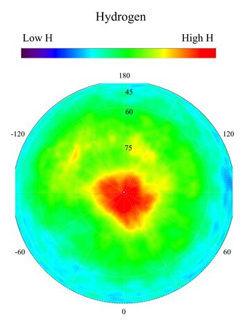
English: This gamma ray spectrometer map centered on the north pole of Mars is based on gamma-rays from the element hydrogen. In this region, hydrogen is mainly in the form of water ice. Regions of high ice content are shown in red and those low in ice content are shown in blue. The very ice-rich region at the north pole is due to a permanent polar cap of water ice on the surface. Elsewhere in this region, the ice is buried under several to a few tens of centimeters of dry soil. The sub-surface ice is not uniformly distributed in the north, but varies with both latitude and longitude. In the north, the soil is well over 50 percent ice, which is more than can be accommodated by just filling the pore space in pre-existing soil. This high ice content implies that the ice may have been slowly co-deposited with dust in the past when conditions were wetter. Deposition of ice by this process means it is more likely that the ice deposits are very thick and may even be deep enough to have liquid water at their base.
NASA's Jet Propulsion Laboratory manages the 2001 Mars Odyssey mission for NASA's Office of Space Science, Washington, D.C. The gamma ray spectrometer was provided by the University of Arizona, Tucson. Lockheed Martin Astronautics, Denver, Colo., is the prime contractor for the project, and developed and built the orbiter. Mission operations are conducted jointly from Lockheed Martin and from JPL, a division of the California Institute of Technology in Pasadena. |
| Date | (published) |
| Source | Catalog page · Full-res (JPEG · TIFF) |
| Author | NASA/JPL-Caltech/ASU |
| Other versions |
|


This image or video was catalogued by Jet Propulsion Laboratory of the United States National Aeronautics and Space Administration (NASA) under Photo ID: PIA04254. This tag does not indicate the copyright status of the attached work. A normal copyright tag is still required. See Commons:Licensing. Other languages:
|
| This media is a product of the 2001 Mars Odyssey mission Credit and attribution belongs to the Gamma Ray Spectrometer (GRS) team, NASA/JPL/University of Arizona |
Licensing
[edit]| This file is in the public domain in the United States because it was solely created by NASA. NASA copyright policy states that "NASA material is not protected by copyright unless noted". (See Template:PD-USGov, NASA copyright policy page or JPL Image Use Policy.) | ||
 |
Warnings:
|
File history
Click on a date/time to view the file as it appeared at that time.
| Date/Time | Thumbnail | Dimensions | User | Comment | |
|---|---|---|---|---|---|
| current | 00:31, 23 January 2018 |  | 1,163 × 1,579 (2.05 MB) | Jarnsax (talk | contribs) | =={{int:filedesc}}== {{NASA Photojournal | catalog = PIA04254 | image = yes | mission = 2001 Mars Odyssey | instrument = Gamma Ray Spectrometer Suite | caption = {{en|This gamma ray spectrometer map centered on the north po... |
You cannot overwrite this file.
File usage on Commons
The following 4 pages use this file: