File:PIA22349 – Gullies of Matara Crater.jpg

Original file (2,880 × 1,800 pixels, file size: 4.9 MB, MIME type: image/jpeg)
Captions
Captions
Assessment[edit]
|
Summary[edit]
| Description |
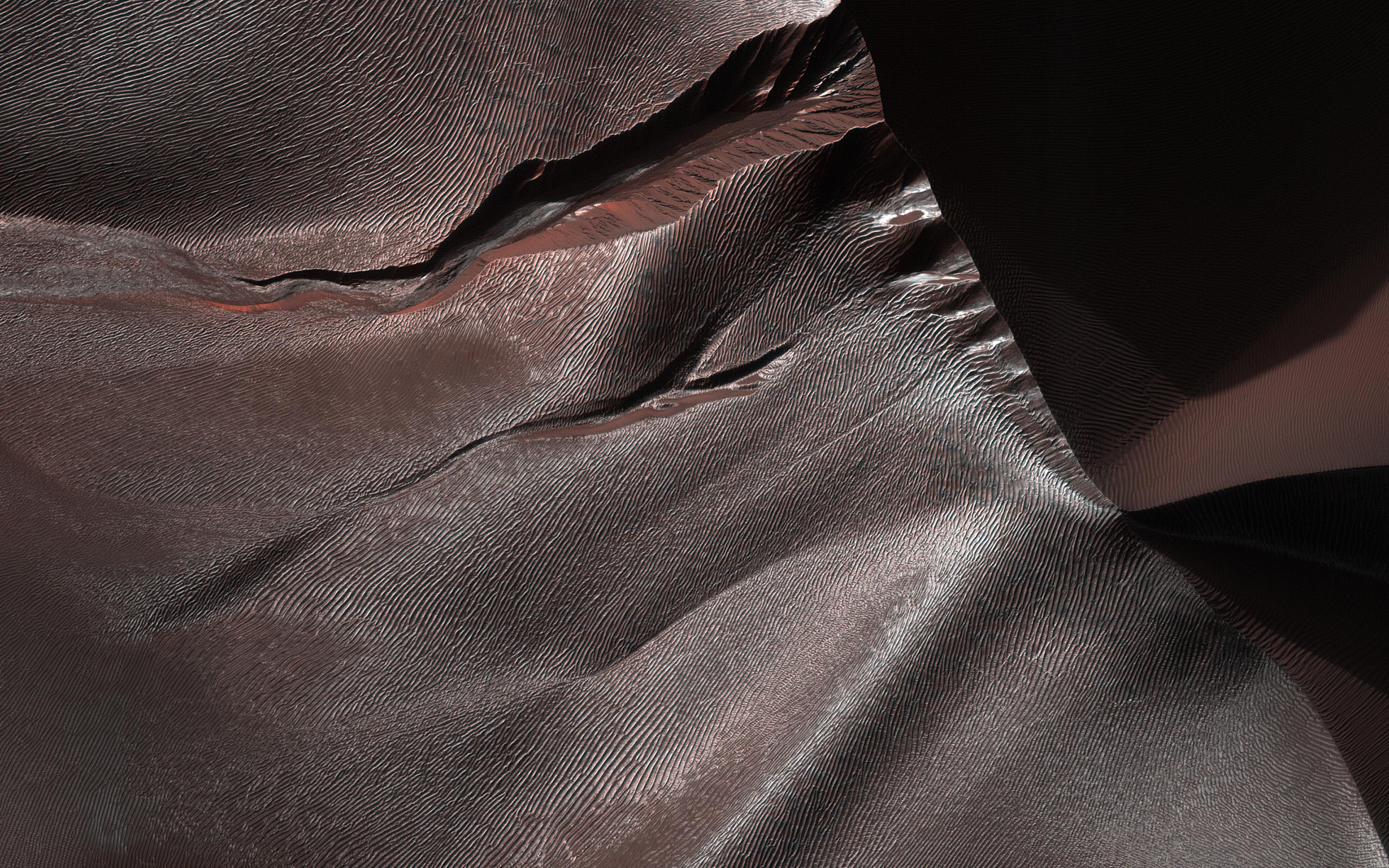
English: Gullies on Martian sand dunes, like these in Matara Crater, have been very active, with many flows in the last ten years. The flows typically occur when seasonal frost is present.
In this image from NASA's Mars Reconnaissance Orbiter we see frost in and around two gullies, which have both been active before. (View this observation to see what these gullies looked like in 2010.) There are no fresh flows so far this year, but HiRISE will keep watching. The map is projected here at a scale of 50 centimeters (19.7 inches) per pixel. [The original image scale is 50.3 centimeters (19.8 inches) per pixel (with 2 x 2 binning); objects on the order of 151 centimeters (59.4 inches) across are resolved.] North is up. The University of Arizona, Tucson, operates HiRISE, which was built by Ball Aerospace & Technologies Corp., Boulder, Colorado. NASA's Jet Propulsion Laboratory, a division of Caltech in Pasadena, California, manages the Mars Reconnaissance Orbiter Project for NASA's Science Mission Directorate, Washington. |
| Date | 4 February 2018 (published 2 April 2018) |
| Source | Catalog page · Full-res (JPEG · TIFF) |
| Author | NASA/JPL-Caltech/Univ. of Arizona |
| Location on Mars | View this and other nearby images on: Google Maps |
|---|
This image or video was catalogued by Jet Propulsion Laboratory of the United States National Aeronautics and Space Administration (NASA) under Photo ID: PIA22349. This tag does not indicate the copyright status of the attached work. A normal copyright tag is still required. See Commons:Licensing. Other languages:
|
 |
This media is a product of the Mars Reconnaissance Orbiter mission Credit and attribution belongs to the High Resolution Imaging Science Experiment (HiRISE) team, NASA/JPL-Caltech/Univ. of Arizona |
Licensing[edit]
| This file is in the public domain in the United States because it was solely created by NASA. NASA copyright policy states that "NASA material is not protected by copyright unless noted". (See Template:PD-USGov, NASA copyright policy page or JPL Image Use Policy.) | ||
 |
Warnings:
|
File history
Click on a date/time to view the file as it appeared at that time.
| Date/Time | Thumbnail | Dimensions | User | Comment | |
|---|---|---|---|---|---|
| current | 16:35, 7 January 2019 | | 2,880 × 1,800 (4.9 MB) | Kesäperuna (talk | contribs) | 100% JPEG quality from full quality TIFF. |
| 19:20, 16 April 2018 |  | 2,880 × 1,800 (1.11 MB) | PhilipTerryGraham (talk | contribs) | User created page with UploadWizard |
You cannot overwrite this file.
File usage on Commons
The following 16 pages use this file:
- Featured Photographs in the Public Domain
- User:Eatcha/POTY-2018-Round-1-Results
- User:Hidayatsrf/Gallery
- User:Nigreco451/FPGallery
- Commons:Featured picture candidates/File:PIA22349 – Gullies of Matara Crater.jpg
- Commons:Featured picture candidates/Log/April 2018
- Commons:Featured pictures/Astronomy
- Commons:Featured pictures/chronological/2018-A
- Commons:Picture of the Year/2018/Candidates
- Commons:Picture of the Year/2018/R1/Gallery/2018-A
- Commons:Picture of the Year/2018/R1/Gallery/ALL
- Commons:Picture of the Year/2018/R1/Gallery/Astronomy
- Commons:Picture of the Year/2018/R1/Gallery/M04
- Commons:Picture of the Year/2018/R1/v/PIA22349 – Gullies of Matara Crater.jpg
- Commons:WikiProject Aviation/recent uploads/2018 April 16
- Commons:WikiProject Aviation/recent uploads/2019 January 7
File usage on other wikis
The following other wikis use this file:
- Usage on en.wikipedia.org
- Usage on fr.wikipedia.org
- Usage on mg.wikipedia.org