File:Parapet structures at Bent's Old Fort, outside La Junta in Otero County, Colorado LCCN2015632520.tif
Original file (7,087 × 4,730 pixels, file size: 191.85 MB, MIME type: image/tiff)
Captions
Summary[edit]
DescriptionParapet structures at Bent's Old Fort, outside La Junta in Otero County, Colorado LCCN2015632520.tif |
English: Title: Parapet structures at Bent's Old Fort, outside La Junta in Otero County, Colorado
Physical description: 1 photograph : digital, tiff file, color. Notes: Purchase; Carol M. Highsmith Photography, Inc.; 2015; (DLC/PP-2015:068).; Forms part of: Gates Frontiers Fund Colorado Collection within the Carol M. Highsmith Archive.; Occasionally referred to as Fort William, the fort is a 1976 reconstruction of an 1833 fort built by William and Charles Bent, along with Ceran St. Vrain, as a post from which to trade with trappers and Southern Cheyenne and Arapaho Plains Indians for buffalo robes.; Title, date and keywords based on information provided by the photographer.; Credit line: Gates Frontiers Fund Colorado Collection within the Carol M. Highsmith Archive, Library of Congress, Prints and Photographs Division. |
||||||||||||||||||||||||||
Date | Taken on 25 May 2015, 15:52 (according to Exif data) | ||||||||||||||||||||||||||
Source |
Library of Congress
|
||||||||||||||||||||||||||
Author |
creator QS:P170,Q5044454 |
||||||||||||||||||||||||||
Permission (Reusing this file) |
No known restrictions on publication.
|
Camera location | 38° 02′ 26.64″ N, 103° 25′ 46.89″ W | View this and other nearby images on: OpenStreetMap | 38.040733; -103.429693 |
---|
Licensing[edit]
Public domainPublic domainfalsefalse |
This work is from the Carol M. Highsmith Archive collection at the Library of Congress. According to the library, there are no known copyright restrictions on the use of this work. Carol M. Highsmith has stipulated that her photographs are in the public domain. Photographs of sculpture or other works of art may be restricted by the copyright of the artist. |
File history
Click on a date/time to view the file as it appeared at that time.
Date/Time | Thumbnail | Dimensions | User | Comment | |
---|---|---|---|---|---|
current | 07:26, 30 September 2016 | 
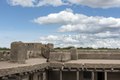
7,087 × 4,730 (191.85 MB) | Fæ (talk | contribs) | LOC 2015632520, Carol M. Highsmith collection. P482.23570 TIFF (191.8mb) |
You cannot overwrite this file.
File usage on Commons
There are no pages that use this file.
Metadata
This file contains additional information such as Exif metadata which may have been added by the digital camera, scanner, or software program used to create or digitize it. If the file has been modified from its original state, some details such as the timestamp may not fully reflect those of the original file. The timestamp is only as accurate as the clock in the camera, and it may be completely wrong.
Image title | Parapet structures at Bent's Old Fort, outside La Junta in Otero County, Colorado. Occasionally referred to as Fort William, the fort is a 1976 reconstruction of an 1833 fort built by William and Charles Bent, along with Ceran St. Vrain, as a post from which to trade with trappers and Southern Cheyenne and Arapaho Plains Indians for buffalo robes. For much of its 16-year history, the fort was the only significant and permanent white American settlement on the Santa Fe Trail between Missouri and the Mexican settlements of what is now New Mexico. It was destroyed under mysterious circumstances (see below) in 1849. The adobe fort quickly became the center of the Bent, St. Vrain Company's expanding trade empire, which included Fort Saint Vrain to the north and Fort Adobe to the south, along with company stores in Taos and Santa Fe. The primary trade was with the Southern Cheyenne and Arapaho Indians for buffalo robes. From 1833 to 1849, the fort was a stopping point along the Santa Fe Trail. It was the only permanent settlement not under the jurisdiction and control of Native Americans or Mexicans.NOTE to RESEARCHERS: There is also a Bent's NEW Fort. Bitter over his unsuccessful attempts to sell it at his price to the Federal government, Willliam Bent moved his gear out in 20 wagons and, according to legend if not historical fact, blew up the first Bent's Fort and established a new, smaller trading post 30 miles away. |
---|---|
Camera manufacturer | NIKON CORPORATION |
Camera model | NIKON D810 |
Author | Carol M. Highsmith |
Exposure time | 1/250 sec (0.004) |
F-number | f/10 |
ISO speed rating | 100 |
Date and time of data generation | 15:52, 25 May 2015 |
Lens focal length | 52 mm |
Latitude | 38° 2′ 26.64″ N |
Longitude | 103° 25′ 46.9″ W |
Altitude | 1,220 meters above sea level |
Width | 7,087 px |
Height | 4,730 px |
Bits per component |
|
Compression scheme | Uncompressed |
Pixel composition | RGB |
Image data location | 32,152 |
Orientation | Normal |
Number of components | 3 |
Number of rows per strip | 4,730 |
Bytes per compressed strip | 201,129,060 |
Horizontal resolution | 300 dpi |
Vertical resolution | 300 dpi |
Data arrangement | chunky format |
Software used | NIKON D810 Ver.1.02 |
File change date and time | 11:08, 29 May 2015 |
Exposure Program | Manual |
Exif version | 2.21 |
Date and time of digitizing | 15:52, 25 May 2015 |
APEX shutter speed | 7.965784 |
APEX aperture | 6.643856 |
APEX exposure bias | 0.33333333333333 |
Maximum land aperture | 3 APEX (f/2.83) |
Metering mode | Pattern |
Light source | Unknown |
Flash | Flash did not fire, compulsory flash suppression |
DateTimeOriginal subseconds | 44 |
Color space | Uncalibrated |
Focal plane X resolution | 2,048.4022216797 |
Focal plane Y resolution | 2,048.4022216797 |
Focal plane resolution unit | 3 |
Sensing method | One-chip color area sensor |
File source | Digital still camera |
Scene type | A directly photographed image |
Custom image processing | Normal process |
Exposure mode | Manual exposure |
White balance | Auto white balance |
Digital zoom ratio | 1 |
Focal length in 35 mm film | 52 mm |
Scene capture type | Standard |
Scene control | None |
Contrast | Normal |
Saturation | Normal |
Sharpness | Normal |
Subject distance range | Unknown |
GPS time (atomic clock) | 21:52 |
Satellites used for measurement | 09 |
Geodetic survey data used | WGS84 |
GPS date | 25 May 2015 |
GPS tag version | 0.0.3.2 |
- United States photographs taken on 2015-05-25
- Images from the Library of Congress
- Files with coordinates missing SDC location of creation
- Library of Congress-no known copyright restrictions
- PD-Highsmith
- Images uploaded by Fæ
- Gates Frontiers Fund Colorado Collection within the Carol M. Highsmith Archive
- Photographs by Carol M. Highsmith
- Taken with Nikon D810
- Pages with maps