File:Pennard Burrows - geograph.org.uk - 1307929.jpg
Jump to navigation
Jump to search
No higher resolution available.
Pennard_Burrows_-_geograph.org.uk_-_1307929.jpg (640 × 480 pixels, file size: 106 KB, MIME type: image/jpeg)
Captions
Captions
Add a one-line explanation of what this file represents
Summary[edit]
| Description |
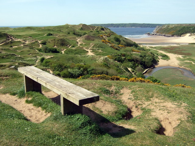
English: Pennard Burrows This view, from near Pennard castle, shows grassed-over sand dunes which, during the C13-15, were responsible for the be-sanding of the castle, the old church, an earlier settlement and agricultural land in this area. Climatic conditions during the period included strong westerlies which blew loose sand inland. The inhabitants found it hard to make a living and to maintain tithes and taxes so were eventually forced out. Subsequently there was a rabbit warren here (although the word burrows, used in South Wales for sand dunes, is not I think rabbit-related in this case.)
The burrows are more stable now but could impending climate change result in further land loss? |
| Date | |
| Source | From geograph.org.uk |
| Author | ceridwen |
| Attribution (required by the license) | ceridwen / Pennard Burrows / |
| Camera location | | View this and other nearby images on: OpenStreetMap |
|---|
_heading:247.00&language=en)
| Object location | | View this and other nearby images on: OpenStreetMap |
|---|
_heading:247.00&language=en)
Licensing[edit]

|
This image was taken from the Geograph project collection. See this photograph's page on the Geograph website for the photographer's contact details. The copyright on this image is owned by ceridwen and is licensed for reuse under the Creative Commons Attribution-ShareAlike 2.0 license.
|
This file is licensed under the Creative Commons Attribution-Share Alike 2.0 Generic license.
Attribution: ceridwen
- You are free:
- to share – to copy, distribute and transmit the work
- to remix – to adapt the work
- Under the following conditions:
- attribution – You must give appropriate credit, provide a link to the license, and indicate if changes were made. You may do so in any reasonable manner, but not in any way that suggests the licensor endorses you or your use.
- share alike – If you remix, transform, or build upon the material, you must distribute your contributions under the same or compatible license as the original.
File history
Click on a date/time to view the file as it appeared at that time.
| Date/Time | Thumbnail | Dimensions | User | Comment | |
|---|---|---|---|---|---|
| current | 14:04, 27 February 2011 | | 640 × 480 (106 KB) | GeographBot (talk | contribs) | == {{int:filedesc}} == {{Information |description={{en|1=Pennard Burrows This view, from near Pennard castle, shows grassed-over sand dunes which, during the C13-15, were responsible for the be-sanding of the castle, the old church, an earlier settlement |
You cannot overwrite this file.
File usage on Commons
There are no pages that use this file.