File:Penshaw Monument (Earl of Durham's Monument) (geograph 5814265).jpg
Jump to navigation
Jump to search
No higher resolution available.
Penshaw_Monument_(Earl_of_Durham's_Monument)_(geograph_5814265).jpg (640 × 480 pixels, file size: 72 KB, MIME type: image/jpeg)
Captions
Captions
Add a one-line explanation of what this file represents
Summary[edit]
_(geograph_5814265).jpg&action=edit§ion=1)
| Description |
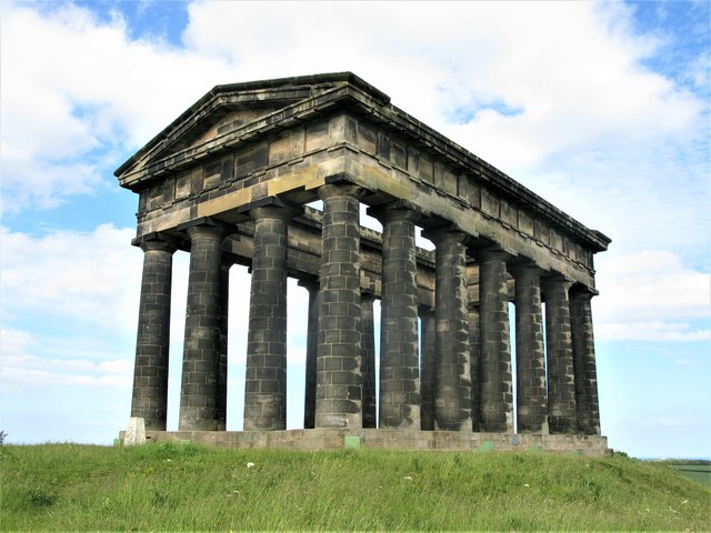
English: Usually called the Penshaw Monument, the correct title of the structure is The Earl of Durham's Monument. Standing on Penshaw Hill, the monument was designed by John and Benjamin Green and built by Thomas Pratt of Sunderland in 1844. It is an adaptation of the Theseum, a Greek temple in Athens, with 18 Doric columns roughly 2 metres in diameter. The sandstone used in the building of the monument is from a local quarry. It was given to the National Trust in 1939 by the fifth Earl of Durham, and is a Grade I listed building.) |
| Date | |
| Source | From geograph.org.uk |
| Author | G Laird |
| Permission (Reusing this file) |
Creative Commons Attribution Share-alike license 2.0 |
| Attribution (required by the license) | G Laird / Penshaw Monument (Earl of Durham's Monument) / |
| Camera location | | View this and other nearby images on: OpenStreetMap |
|---|
_(geograph_5814265).jpg¶ms=054.882620_N_-001.482175_E_globe:Earth_type:camera_source:geograph-osgb36(NZ33325433)_heading:67.00&language=en)
| Object location | | View this and other nearby images on: OpenStreetMap |
|---|
_(geograph_5814265).jpg¶ms=054.882970_N_-001.480920_E_globe:Earth_class:object_type:object_source:geograph-osgb36(NZ33405437)_heading:67.00&language=en)
Licensing[edit]
_(geograph_5814265).jpg&action=edit§ion=2)

|
This image was taken from the Geograph project collection. See this photograph's page on the Geograph website for the photographer's contact details. The copyright on this image is owned by G Laird and is licensed for reuse under the Creative Commons Attribution-ShareAlike 2.0 license.
|
This file is licensed under the Creative Commons Attribution-Share Alike 2.0 Generic license.
Attribution: G Laird
- You are free:
- to share – to copy, distribute and transmit the work
- to remix – to adapt the work
- Under the following conditions:
- attribution – You must give appropriate credit, provide a link to the license, and indicate if changes were made. You may do so in any reasonable manner, but not in any way that suggests the licensor endorses you or your use.
- share alike – If you remix, transform, or build upon the material, you must distribute your contributions under the same or compatible license as the original.
File history
Click on a date/time to view the file as it appeared at that time.
| Date/Time | Thumbnail | Dimensions | User | Comment | |
|---|---|---|---|---|---|
| current | 16:50, 1 June 2023 | | 640 × 480 (72 KB) | Chocolateediter (talk | contribs) | == {{int:filedesc}} == {{Information |Description={{en|1=Usually called the Penshaw Monument, the correct title of the structure is The Earl of Durham's Monument. Standing on Penshaw Hill, the monument was designed by John and Benjamin Green and built by Thomas Pratt of Sunderland in 1844. It is an adaptation of the Theseum, a Greek temple in Athens, with 18 Doric columns roughly 2 metres in diameter. The sandstone used in the building of the monument is from a local quarry. It was given to t... |
You cannot overwrite this file.
File usage on Commons
There are no pages that use this file.
File usage on other wikis
The following other wikis use this file:
- Usage on en.wikipedia.org
_(geograph_5814265).jpg&oldid=769544766)