File:Perersdorf - Kirchenruine St. Cäcilia.JPG
Jump to navigation
Jump to search

Size of this preview: 800 × 533 pixels. Other resolutions: 320 × 213 pixels | 640 × 427 pixels | 1,024 × 683 pixels | 1,280 × 853 pixels | 2,560 × 1,707 pixels | 4,800 × 3,200 pixels.
Original file (4,800 × 3,200 pixels, file size: 9.36 MB, MIME type: image/jpeg)
Captions
Captions
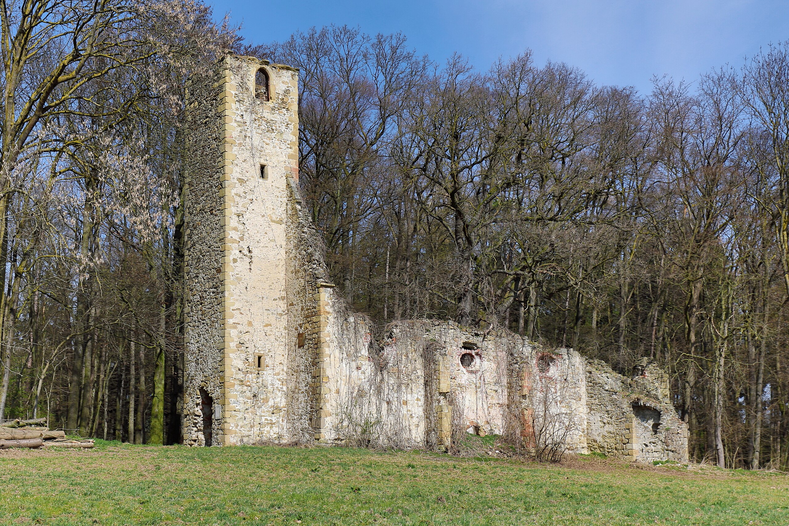
Church ruins of St. Cecilia in Pyhra, Lower Austria.
Summary[edit]
| Description |
Deutsch: Südsüdwestansicht der Kirchenruine St. Cäcilia in Perersdorf, eine Ortschaft in der niederösterreichischen Marktgemeinde Pyhra.
Die Kirche mit Westturm wurde auf eine kleinen Anhöhe und auf halbem Weg an der Straße von Pyhra nach Böheimkirchen, nahe Perersdorf, im 14. Jahrhundert errichtet. Das ehemalige Kirchenschiff weist eine Länge von 27 Metern auf, das Presbyterium ist 6 Meter und das Schiff 8 Meter breit. Der 30 Meter hohe Turm sowie südseitig eine kleine gewölbte Sakristei sind ebenfalls erhalten. Rund um die Kirche lag einst auch der Friedhof. Spätestens seit Anfang des 19. Jahrhundert ist die Kirche dem Verfall preisgegeben: [1]. English: Church ruins of St. Cecilia in Pyhra, Lower Austria.
|
| Date | |
| Source | Own work |
| Author | C.Stadler/Bwag |
| Permission (Reusing this file) |
Deutsch: Hallo, du darfst mein Foto kostenlos nutzen, aber nenne mich bitte als Fotograf, beispielsweise „Foto: C.Stadler/Bwag“ oder © C.Stadler/Bwag; CC-BY-SA-4.0. Auf mehr Angaben bestehe ich nicht - im Gegensatz zu manch anderen, die die Vorgaben der unten angeführten Lizenzierung auf Punkt und Beistrich einfordern. English: Feel free to use my photos, but please mention me as the author like © C.Stadler/Bwag or © C.Stadler/Bwag; CC-BY-SA-4.0 (that's good enough) and if you want send me a message: bwag@gmx.net. |
| Object location | | View this and other nearby images on: OpenStreetMap |
|---|
| Camera location | | View this and other nearby images on: OpenStreetMap |
|---|
Licensing[edit]
I, the copyright holder of this work, hereby publish it under the following license:
This file is licensed under the Creative Commons Attribution-Share Alike 4.0 International license.
- You are free:
- to share – to copy, distribute and transmit the work
- to remix – to adapt the work
- Under the following conditions:
- attribution – You must give appropriate credit, provide a link to the license, and indicate if changes were made. You may do so in any reasonable manner, but not in any way that suggests the licensor endorses you or your use.
- share alike – If you remix, transform, or build upon the material, you must distribute your contributions under the same or compatible license as the original.
File history
Click on a date/time to view the file as it appeared at that time.
| Date/Time | Thumbnail | Dimensions | User | Comment | |
|---|---|---|---|---|---|
| current | 11:08, 23 March 2023 | | 4,800 × 3,200 (9.36 MB) | Bwag (talk | contribs) | == {{int:filedesc}} == {{Information |Description= {{de|1= Südsüdwestansicht der Kirchenruine ''St. Cäcilia'' in Perersdorf, eine Ortschaft in der niederösterreichischen Marktgemeinde Pyhra.<br/>Die Kirche mit Westturm wurde auf eine kleinen Anhöhe und auf halbem Weg an der Straße von Pyhra nach Böheimkirchen, nahe Perersdorf, im 14. Jahrhundert errichtet. Das ehemalige Kirchenschiff weist eine Länge von 27 Metern auf, das Presbyterium ist 6 Meter und das Schiff 8 Meter breit. Der 30 Meter h... |
You cannot overwrite this file.
File usage on Commons
The following page uses this file:
File usage on other wikis
The following other wikis use this file:
- Usage on de.wikipedia.org
- Usage on en.wikipedia.org
- Usage on www.wikidata.org